The Highlands Province
The region's most ancient rocks are the foundation of the Highlands region. Metamorphic and igneous rocks of Late Precambrian and Early Paleozoic age crop out in northeast-trending belts of rock forming the core of the Appalachian Mountains in the New York Bight region. The area is a rugged, hilly to mountainous terrain, bearing the characteristic scars of Pleistocene glaciation. The rocky outcrops visible on hillsides, and along stream banks and roadside exposures, consist mostly of gneiss, schist, and marble. The Manhattan skyline owes its existence to the durable character of this bedrock foundation. Some of the most scenic hiking areas in the region are found in the Highlands.
The literature is filled with conflicting definitions as to how the geographic areas surrounding the New York Bight should be subdivided. The rocks of the Highlands Province are a part of the "Crystalline Appalachians." This name refers to the term crystalline rock, a general term for igneous and metamorphic rock (as opposed to sedimentary rock) where the rock consists of minerals in an obviously crystalline state. The Highlands region is equivalent to the ancient, worn-down mountains of the Piedmont and Blue Ridge Provinces in North Carolina and Virginia, and is equivalent to the New England Upland Province to the north. Although the Newark and Connecticut River basins are equivalent to Triassic age basins of the Piedmont to the south, for this discussion, the Highlands Province is limited to exposures of Precambrian and Early Paleozoic metamorphic and igneous rocks throughout portions of northern New Jersey, Southern New York, and most of Connecticut.
The Highlands Province is subdivided into several regions (Figure 10). The Reading Prong extends from southeastern Pennsylvania into the upland areas of northern New Jersey where it is called the New Jersey Highlands. This belt continues into southeastern New York where it is called the Hudson Highlands. Equivalent rocks in western Connecticut are called the Housetonic Highlands. The Manhattan Prong is a smaller belt of ancient rock in southern New York (including Manhattan, the Bronx, and segments of Brooklyn and Staten Island), parts of Westchester County, and upland portions of southwestern Connecticut.
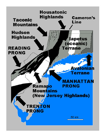 |
| Figure 10. The Highlands Province. |
The Manhattan and Reading Prongs are separated by the Newark Basin in the south, but the two features merge at the northern terminus of the Newark Basin in the vicinity of Peekskill, New York. A band of mountains that rise nearly one thousand feet along the northwestern margin of the Newark Basin in New York and New Jersey are called the Ramapo Mountains. Another belt of ancient metamorphic and igneous rock crops out along the southern margin of the Newark Basin south and west of Trenton, New Jersey. In this region the rocks are referred to as part of the Trenton Prong.
The Taconic Mountains consist of complexly folded and faulted Early Paleozoic rocks which, in part, have not been subjected to the high degree of metamorphism as rocks to the south and east. The Iapetus and Avalonian terranes in Connecticut consist of intensely metamorphosed Precambrian and Early Paleozoic rocks, and are defined, in part, by aspects of their geologic history (discussed below).
The geology of the Highlands Province is exceedingly complicated, and many aspects of the region's geologic history are not clearly resolved. Detailed geologic maps of the region show complex patterns of folds, faults, and intrusions. These ancient rocks compose the basement beneath the younger, overlying sedimentary strata of the Valley and Ridge Province, the sedimentary and volcanic rocks of the Newark and Connecticut River Basins, and the poorly consolidated sediments of the Coastal Plain. The rocks have been subjected to several episodes of tectonic deformation, including stages of intense folding and metamorphism associated with the collision of ancient landmasses driven by plate tectonic forces. Following these mountain building episodes of the Paleozoic, this region has endured extensive periods of gradual uplift and erosion lasting throughout Mesozoic and Cenozoic time. As a result, the highest peaks in the Appalachian region generally consist of ancient crystalline rocks that are more resistant to erosion. River valleys generally follow along fractured zones and faults, or along outcrop belts of rocks that preferentially weather and erode faster.
The Grenville Orogeny
The oldest exposures of Precambrian rock in the New York Bight region are estimated
at 1.3 to 1.1 billion years old (Middle Proterozoic). Whether older rocks existed
at one time in the region is unknown; they have long since been destroyed by
erosion, or have been incorporated deep into the crust or possibly back into
the mantle. The majority of these ancient rocks, however, have been subjected
to repeated episodes of metamorphism so that their radiogenic dates have been
reset to younger ages, mostly around 0.8 billion years ago. The early stages
of alteration occurred in an extensive mountain-building episode that affected
the entire eastern margin of North America extending as far west as Ohio and
Kentucky. This mountain-building episode is collectively known as the Grenville
Orogeny which began roughly 1.3 billion years ago (Middle Proterozoic), and
ended roughly around 800 million years ago (Late Proterozoic)(Figure 11A). During
this period older rocks and sediments deposited along the south and eastern
margin of the Canadian Shield underwent deep burial and metamorphic alteration.
Many igneous intrusions occurred in the region. Some of these igneous bodies
were probably sills or flows preserved within sequences of sedimentary rocks,
later to become metamorphosed during subsequent stages of the orogeny. Others
large magma chambers cooled slowly deep in the crust, becoming the granitic
core of many mountains in the Highlands region (such as Bear Mountain, New York).
Through much of their history these rocks were deeply buried, probably many
miles beneath the Earth's surface. Their overburden has long been stripped away
by erosion.
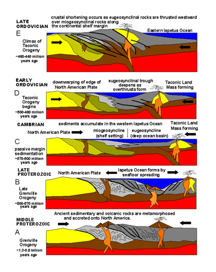 |
| Figure 11. Plate tectonic configuration during Late Precambrian through Early Paleozoic time for the New York City region (not to scale). |
A long period of uplift and erosion followed the Grenville Orogeny. Beginning
roughly 700 million years ago rifting began along the eastern edge of the North
American continent (Figure 11B). This divergence (rifting) led to the formation
of the ancient Iapetus Ocean (a waterway that has since vanished by later collisions
between continents). According to Greek Mythology, Iapetus was the father of
Atlas, the name-sake of the Atlantic Ocean.
Through late Proterozoic into Cambrian time, sediments derived from upland areas
to the north and west accumulated along a continental shelf margin and within
a deep ocean trough farther offshore. The shallow shelf margin followed a general
trend along the southeastern edge of the New Jersey, Hudson , and Housetonic
Highlands. On the shallow shelf regions well-sorted quartz sandstone and carbonate
rocks (limestone and dolomite) were deposited. This continental shelf sequence
accumulated to the thickness of several miles, forming an elongated sedimentary
basin referred to as a miogeocline (Figure 11C). To the east, a deep water trough
filled with fine-grained sediments (mainly shales) derived from both the continent
and from volcanic island arc systems that were emerging far offshore within
the Iapetus Ocean basin. This deep water basin sequence is referred to as a
eugeocline. To the south and east, this basin was underlain by basaltic crust
of the ancient Iapetus Ocean (see Figure 11C). Sedimentation in this basinal
trough persisted until Middle Ordovician time.
The Taconic Orogeny
The Taconic Orogeny was a great mountain building period that perhaps had the greatest overall effect on the geologic structure of basement rocks within the New York Bight region. The effects of this orogeny are most apparent throughout New England, but the sediments derived from mountainous areas formed in the northeast can be traced throughout the Appalachian and Midcontinent regions of North America. The following discussion provides a summary of events leading to the culmination of this orogeny.
Beginning in Cambrian time (about 550 million years ago) the Iapetus Ocean began to grow progressively narrower. The weight of accumulating sediments, in addition to compressional forces in the crust, forced the eastern edge of the North American continent to gradually fold downward (Figure 11D). In this manner, shallow carbonate deposition that had persisted on the shelf margin through Late Cambrian into Early Ordovician time, gave way to fine-grained clastic deposition and deeper water conditions during the Middle Ordovician. Sometime during this period a convergent plate boundary developed along the eastern edge of a small island chain. Crustal material beneath the Iapetus Ocean sank into the mantle along a subduction zone with an eastward-dipping-orientation. Partial melting of the down-going plate produced magma that returned to the surface to form the Taconic island arc offshore from the continent. By the Late Ordovician, this island arc had collided with the North American continent. The sedimentary and igneous rock between the land masses were intensely folded and faulted, and were subjected to varying degrees of intense metamorphism (Figure 11E). This was the final episode of the long-lasting mountain-buliding period referred to as the Taconic Orogeny.
When the Taconic Orogeny subsided in the New York Bight region during Late Ordovician time (about 440 million years ago), subduction ended, culminating in the accretion of the Iapetus Terrane onto the eastern margin of the continent. This resulted in the formation of a great mountain range throughout New England and eastern Canada, and perhaps to a lesser degree, southward along the region that is now the Piedmont of eastern North America. The newly expanded continental margin gradually stabilized. Erosion continued to strip away sediments from upland areas. Inland seas covering the Midcontinent gradually expanded eastward into the New York Bight region and became the site of shallow clastic and carbonate deposition. This tectonically-quiet period persisted until the Late Devonian time (about 360 million years ago) when the next period of mountain-building began, the Acadian Orogeny.
Major Rock Groups
Rock units of Precambrian and Lower Proterozoic Age have been subdivided into numerous formations and members, with different names applied to equivalent-age rock units from one region to the next. More detailed descriptions of local and regional stratigraphy are available in many reports and maps cited in the reference section of this book. The list of rock groups in Figure 12 is both generalized and incomplete; however, it highlights the major rock groups that crop out within the New York Bight region. More detailed discussion of some of these units are incorporated into the following locality descriptions.
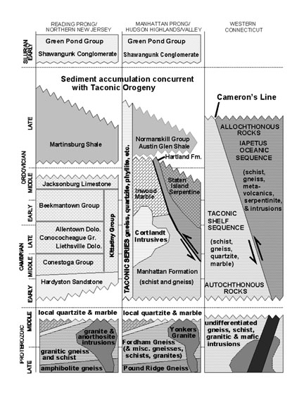 |
| Figure 12. Generalized Precambrian and Lower Paleozoic stratigraphy for the New York City region (modified after American Association of Petroleum Geologists COSUNA Charts (1983, 1986), Drake and others (1986), Fisher and others (1995), and Rodgers (1985). |
When traveling across the region from the north and west toward the south and east the rocks of lower Paleozoic age display increasing stages of metamorphism. This is because this region was subjected to higher degree of deformation associated with the Taconic Orogeny. For instance, the Late Cambrian and Early Ordovician limestone and dolomite of the Kittatinny Group in northwestern New Jersey are equivalent to the Inwood Marble in the Manhattan Prong region. Likewise, the Late Ordovician Martinsburg and Normanskill shales are equivalent to the Manhattan Schist. All rocks in the region formed prior to or during the Taconic Orogeny were also subjected to additional deformation episodes during the Acadian and Alleghenian Orogenies later in the Paleozoic.
Mountains Without "Roots"
During the process of continental collision and accretion, rocks in the crust are subjected to great forces of pressure. They eventually yield to this pressure by bending or fracturing. If the rock is confined under great pressure they will flow gradually like plastic, resulting in the formation of folds (anticlines and synclines [Figure 13]). Such evidence of plastic deformation can be observed on the scale of a small hand specimen or traced to a series of folds on a scale of tens or even hundreds of miles. If the pressure is applied too rapidly the rocks will behave in a more brittle manner forming fractures (joints and faults). A joint differs from a small fault in that a fault displays evidence of visible offset. In many cases faults are only observed on the surface as a relative change in lithology from one surface outcropping to the next.
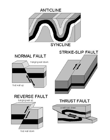 |
| Figure 13. Types of faults and folds. |
Though time, rocks respond to crustal pressure by folding or moving passively past one another along faults. Earth movement is typically an extremely slow, gradual process. However, when pressure builds beyond the point to which rocks can gradually yield they may suddenly break and move, causing an earthquake. Earthquakes are measured by different levels of intensity (see additional discussion in the Human Impacts chapter). Most earthquakes are imperceptible to humans; only great quakes are capable of causing damage and creating visible changes on the Earth's surface. Earth displacements measured following the greatest earthquakes in modern times are only measured in the order of several dozens of feet.
During the mountain-building episodes during the Paleozoic, great piles of
thrust sheets piled one on another, built up into mountain ranges along the
eastern margin of North America. As mountain building proceeded, certain faults
may have been active for a time, then motion may have ceased as active displacement
occurred along new fault systems or along other older fracture zones. In many
fault systems relative motion is of strike-slip displacement, where one rock
mass to move horizontally past another, in some cases for great distances. Over
the course of geologic time, fault systems may become reactivated with relative
motion changing from one episode to the next. Several major thrust fault systems
are known throughout the New York Bight region; some display a large degree
of strike-slip offset.
Perhaps the greatest fault system in the New York Bight region is known as Cameron's
Line, named after Eugene N. Cameron, a U.S. Geological Survey geologist who
first recognized its significance as a great suture between rocks of widely
different origins. Cameron's Line winds southward out of New England into Western
Connecticut and passes through southern New York across the Bronx, following
the general trend of the East River. It extends beneath sedimentary cover on
Staten Island and southward beneath the Coastal Plain of New Jersey. In general,
basement rocks to the west of Cameron's Line are regarded as autochthonous,
meaning that they have not been significantly displaced by tectonic processes.
The rocks to the west of Cameron's Line include metamorphosed sedimentary material
originally comprising ancient continental slope, rise, and shelf deposits, collectively
described as a miogeocline (see Figure 11C and Figure 12). The rocks to the
east of Cameron's Line are allochthonous, which means they have been shoved
westward over autochthonous basement rocks on the order of many tens or even
hundreds of kilometers. These rocks were originally deposited as sediments in
a deep water basin called a eugeocline. Cameron's Line may represent the trace
of a subduction zone that ceased when the smaller Taconic Landmass, a small
terrane consisting of oceanic crust and a complex island arc system, collided
with, and became accreted onto, the eastern margin of North America during the
Taconic Orogeny. Much of the rocks east of Cameron's Line were once part of
the floor of the Iapetus Ocean (the Iapetus Terrane).
Rocks to the west of Cameron's Line have also been displaced along great thrust faults. These faults generally dip steeply near the surface, but decrease to shallow angles in the subsurface. As with most thrust faults in the region, older metamorphic rocks have been shoved westward over younger sedimentary rocks of Cambrian and Ordovician age. In many areas there are numerous thrust sheets. The term, imbrication, is used to describe great massifs of rock in which sequences of stratigraphic intervals are repeated in stacked vertical succession. This is particularly evident in the Taconic Mountains, throughout the Hudson Valley, and in portions of the New Jersey Highlands. In several locations of the Highlands region the upland areas are underlain by Precambrian gneisses whereas the exposures along the stream valleys consist of Cambrian and Ordovician shales and limestones. The Precambrian gneisses have been shoved north and west over the younger sedimentary rocks along great thrust faults. The occurrence of older, more resistant crystalline rocks forming the core of a mountain, with an adjacent valley underlain by softer sedimentary rocks gives the impression of "mountains without roots."
Field Trips Sites In The Highlands
The Highlands Region is host to a wide variety of geology field trip destinations. The localities described below were chosen for their geologic characteristics, their scenic setting, and their general accessibility on public lands. All sites are within about a two hour drive from practically anywhere in metropolitan area (excluding traffic!). In most field location there are usually many geologic features to look at: the composition and character of the bedrock; geologic structures (such as folds or faults); weathering, erosion, and glacial features; and in most cases, scenic views of the regional landscape. All of these components provide the observer with evidence for the rich geologic history of a location. Knowledge of the bedrock geology is essential for understanding aspects of the natural ecology and the cumulative and changing history of human land use.
Although many classic geologic localities occur along road cuts in the region they have been intentionally excluded from this collection because it is both unsafe and illegal to stop along most highway exposures. Some of the most spectacular outcrops in the Highlands region occur along the New York Thruway, Merrick Expressway, Cross Bronx Expressway, the Taconic Parkway, I-287, and many other highways in the region. Unfortunately, curiosity-driven rock-hounds have caused highway accidents, some resulting in major traffic jams; even deaths have occurred. Fortunately, as the discussion below illustrates, there are many places where classic exposures are preserved and protected. In general, rock collecting is strictly prohibited on park lands (with stiff fines!), however, there is no shortage of places where fossils, rocks, and minerals may be collected both legally and safely. Collecting is best when it is done with a group of knowledgeable enthusiasts during an organized field trip. The best method of collecting, however, is with a camera!
Highlands Sites Within New York City
Accessible outcrops of crystalline basement rocks occur throughout parklands
in Manhattan, the Bronx, and Staten Island. Rubble from construction of buildings
and tunnels are scattered throughout the city, used in the construction of seawalls,
groins, and jetties, as well as in many buildings and infrastructure throughout
the city. The localities included below are only a partial selection of potential
study sites. They have been chosen because many are well known or "classic"
sites that have been examined and re-examined throughout the history of geologic
investigations of the city's bedrock foundation. Public locations within New
York City that feature Highlands geology discussions include:
Geology of Northern Manhattan and The Bronx
1. Central Park
2. Cloisters Museum/Fort Tryon Park
3. Inwood Hill Park/Isham Park
4. Crotana Park
5. New York Botanical Gardens and Bronx Zoo Park
6. Pelham Bay Park
7. Staten Island Serpentinite
Hudson Highlands of New York
The Hudson Highlands region represents the outcrop belt of crystalline basement rocks of the northeastern extension of the Reading Prong (see Figure 10). The Hudson Highlands are a northern extension of the Ramapo Mountains in northern New Jersey. To the north and east, the boundary between the Hudson Highlands, the Taconic Mountains, and the Western Connecticut Uplands region is indistinct, partly because of the occurrence of numerous thrust faults and large igneous Middle Paleozoic intrusions in the region. In general, the name Hudson Highlands refers to the low mountains or high hills that border the Hudson River north of Peekskill and south of Newburgh, New York. Links to Highlands in the Hudson River region include:
Geology of the Hudson Highlands region
8. Harriman State Park
9. Bear Mountain State Park
10. Anthony's Nose Overlook
11. Mianus River Gorge
Highlands Sites in Western Connecticut
Connecticut preserves a wealth of spectacular geology in many scenic parks. For a discussion of Highlands geology in Connecticut and trip sites in the Housetonic Mountains, check out:
Geology of the Connecticut Highlands
Of the choices to drive north and east from New York City into Connecticut,
the Merritt Parkway provides a more scenic alternative over I-95. There are
numerous spectacular roadside exposures of dark gneisses and schists with light
colored veins of quartz, migmatite, and pegmatite. Unfortunately, these outcrops
are nowhere safe for casual roadside examination. Suitable exposures for study
might be found along exits on the parkway. One suitable field site in the Connecticut
Panhandle is:
12. Audubon Center.
The Housetonic Mountains in northwestern Connecticut are a wonderful destination for a long day trip or a weekend outing. There are numerous state parks, and roadside picnic areas along scenic highways. US Highway 7 is a major scenic route leading north from Danbury into this mountainous region with numerous peaks rising above 1,500 feet. Mt. Fissell, the highest peak in Connecticut located at the northwestern corner of the state reaches an elevation of 2380 feet. Two places to consider visiting first are:
13. Kent Falls State Park
14. Macedonia Brook State Park
Highlands Locations in New Jersey
New Jersey has perhaps the most varied and accessible public lands within the Highland Province. The selection below provides some of the best know geologic wonders in the region. In addition to being host to interesting rocks and minerals, all these localities provide unique information about earth history relating to the formation of the North American continent from the Late Precambrian through the Paleozoic Era, and also provide spectacular examples of glacial features and modern landscape development. Discussion and sites in the New Jersey Highlands include:
The New Jersey Highlands (and Ramapo Mountains)
15. Pyramid Mountain Natural Historic Area
16. Norvin Green State Park
17. Route 23 Rest Area
18. Wawayanda State Park
19. Franklin/Ogdensburg Mineral Resource Area
Geology along Interstate 80 in the New Jersey Highlands
20. Jenny Jump State Park
Geology along Interstate 78 in the New Jersey Highlands
21. Round Valley State Park
22. Leigh Cavern
| Continue to the Valley and Ridge Province. |