Highlands Sites in Western Connecticut
Connecticut is subdivided into three physiographic provinces: the Western Uplands, the Central Lowlands, and the Eastern Uplands. The Housetonic Mountains comprise the northwestern corner of the state within the Western Uplands. The bedrock geology of this region is highly complex because of the deformation associated primarily with the Taconic Orogeny. Cameron's Line, the great thrust fault between miogeosynclinal rocks (consisting of continental shelf and slope materials) and eugeosynclinal rocks (deep ocean basin sediments), was first recognized in the Highlands of western Connecticut. The traces of this great fault system winds from the Connecticut Panhandle region into southern New York and back into the Western Uplands region. Throughout the Western Uplands and the Taconic Region of eastern New York, eugeosynclinal rocks (deep ocean basin rocks of the Iapetus terrane) overly miogeosynclinal rocks (shallow shelf and shelf margin rocks). In many places erosion has carved down through the thrust sheet isolating large portions of the overthrust (the displaced rocks above the thrust fault). The result is that the allochthonous tops of some mountains in the region are older than their bases! A klippe is a geologic name applied to a valley where streams have carved downward through an overthrust sheet exposing autochthonous basement rocks. At the end of Ordovician time, the overthrust sheet had moved westward over basement rock from the region of central western Connecticut to the vicinity of the Hudson River Valley in the eastern Hudson River Valley region of New York, a distance of about 80 kilometers.
The Lower Paleozoic rocks of the Iapetus Terrane (east of Cameron's Line) consist of well-layered micaceous schist, and granite and hornblende gneiss together with intricately folded amphibolite gneiss and scattered gabbro and serpentinite. The lack of carbonate rocks in this terrane is perhaps the best indication that these rocks were derived from a deep water setting. Rocks of the Iapetus Terrane also display a higher degree of metamorphism than rocks of the continental shelf margin (to the west). This is because they endured the effects of the Taconic and Acadian Orogenies for a much longer period of time and with greater metamorphic intensity.
The rocks beneath the great overthrust also experienced high temperature deformation and in places are broken by series of smaller faults. The core of the Taconic Mountains in eastern New York and the Housetonic Mountains in northwestern Connecticut consists of crystalline basement rocks (gneisses and schists) of Middle Proterozoic age (1.1 to 0.9 billion years). These exposures are a part of a belt of Proterozoic gneisses and granites in Hudson Highlands region extending northward to the core of the Berkshire and Green Mountains in New England. Depending on the degree of metamorphism, these rocks are overlain by Lower Cambrian sandstone (quartzite), Middle to Late Cambrian dolomitic limestone (marble), and Middle to Late Ordovician shale (phyllite and schist).
Of the choices to drive north and east from New York City into Connecticut, the Merritt Parkway provides a more scenic alternative over I-95. There are numerous spectacular roadside exposures of dark gneisses and schists with light colored veins of quartz, migmatite, and pegmatite. Unfortunately, these outcrops are nowhere safe for casual roadside examination. Suitable exposures for study might be found along exits on the parkway. One suitable field site in the Connecticut Panhandle is the: 12. Audubon Center.
Housetonic Mountains
The Housetonic Mountains in northwestern Connecticut are a wonderful destination for a long day trip or a weekend outing. There are numerous state parks, and roadside picnic areas along scenic highways. US Highway 7 is a major scenic route leading north from Danbury into this mountainous region with numerous peaks rising above 1,500 feet. Mt. Fissell, the highest peak in Connecticut located at the northwestern corner of the state reaches an elevation of 2380 feet. Two places to consider visiting first are 13. Kent Falls State Park and nearby 14. Macedonia Brook State Park (Figure 34).
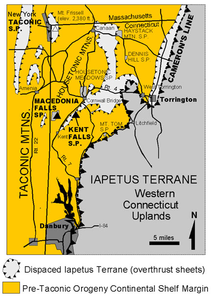 |
| Figure 34. Map of the northwestern Connecticut region (map modified after Fisher et al., 1996 and Rogers, 1985). |
| Return to the Highlands Province Main Page. |