13. Kent Falls State Park
Kent Falls is a spectacular staircase waterfall that tumbles nearly four hundred feet off the side of a mountain (Figure 35). Only the lower portion of the falls is visible from the roadside parking area. The short but mildly strenuous climb to the top of the falls is well worth the half-mile walk. The path is a heavily worn track with rock stairways and fenced overlooks in need of repair. Despite the worn condition of the trail, the scenery is spectacular. The 295 acre park is located about five miles north of Kent, Connecticut on US Highway 7. The park has limited picnic facilities. Like most state parks in the region there is a day use admission fee.
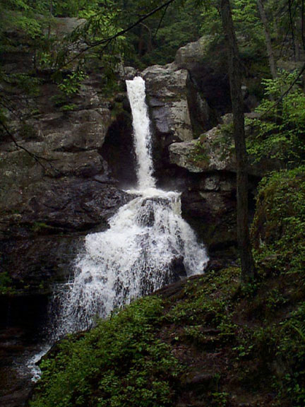 |
| Figure 35. The lower cascades of Kent Falls State Park, Connecticut. |
The falls tumble down the side of a mountain in a series of benches, cataracts, and cascades. Along the stream there are many circular potholes carved by the swirling water, including several that have become isolated from the stream through the progress of erosion. The broad upland area above the falls is an ample precipitation catchment area to provide a constant heavy stream year-round.
The valley of the Housetonic River which flows along US Route 7 is underlain by the Stockbridge Marble, a white to gray dolomitic marble of Late Cambrian and Early Ordovician age. This rock crops out along river level beneath a great thrust sheet that runs the length of the valley between Cornwall, CT and Bulls Bridge, CT on US Highway 7. The slope on the east side of the valley is allochthonous terrane, consisting of schists and gneiss typical of rocks east of Cameron's Line (Early Cambrian age Hartland-Manhattan Schist). The staircase nature of the falls is partly a result of differing zones of weakness associated with smaller imbricated thrust faults exposed along the westward-facing flank of the mountain.
One of the best exposures of a thrust fault is near the top of the falls trail. Along the trail close to the top of the hill are several small outcrops of a bright white quartz sandstone and quartzite. This sandstone has eroded back much faster than the gneiss above and below it. The cascade at the top of the hill spills over a resistant rock ledge of gneiss; the thrust fault appears as a visibly weathered crack along the steep hillside at the base of this spectacular falls. The sandstone and quartzite is probably a sliver of basal Cambrian Cheshire Quartzite that was transported to its current location attached to the bottom surface of the thrust sheet.
Once again it is important to note that these rocks were once deeply buried. The land has risen through time, and has been exposed to erosion for nearly half a billion years, removing several miles of overlying rocks. Perhaps the best indication of this is that portions of the same thrust sheet exposed at Kent Falls also occur more than a dozen miles to the west throughout the Taconic Mountains region along the border of New York and Connecticut. Erosion has carved down through this great allochthonous thrust sheet and exposed the basement rocks of the continental shelf margin sequence underneath. These rocks crop out throughout the area nearby in Macedonia Brook State Park.
| Return to the Highlands Province Main Page. |