16. Norvin Green State Park
Norvin Green State Park is located in the Ramapo Mountains region of the New Jersey Highlands. To get there, take I-287 to exit 57, follow Skyline Drive to Greenwood Lake Turnpike to West Brook Road, and then to Snake Den Road. Parking for the trail system encompassing the park and the bordering forested preserve around Wyanokie Reservoir is at the Weiss Ecology Center. The center offers overnight accommodations and may charge a daily parking fee during the summer.
The trail system is quite rugged, involving climbs in elevation from 400 to 1,300 feet. Norvin Green includes part of the Highlands Trail, which upon completion will extend from the Delaware River to the Hudson River. Spectacular views from bald areas on the mountain tops extend eastward to include the Manhattan skyline. The bald patches on the mountaintops are called "pine paddies." Pitch pines are able to grow in the cracks and gravel patches around these glacier-scoured hilltop exposures. Their expanding roots and decaying needles slowly weather the rock into soil, providing a footing for the succession of plants to follow.
The bedrock in the area consists dominantly of Proterozoic hornblende and biotite granite, quartz-diorite gneiss, and highly foliated amphibolite gneiss. Veins of magnetite-rich, biotite-hornblende gabbro were mined in the vicinity. The Blue Mine ore body was discovered in 1765 and was mined intermittently until late in the nineteenth century. The nearby Roomy Mine is a smaller underground excavation opened in 1840. Extreme care should be used when examining the mines! They are accessible along a trail marked with red blazes that starts about 150 feet south of the Weiss Ecology Center parking area on Snake Den Road. (The trail runs along the border between private residences, so please be courteous! The name "snake den" is appropriate in that garter snakes, as well as other varieties, gather and nest in abundance in this area during the winter.) Several abandoned mining roads and paths intersect the trail, but stay with the red trail. Approximately a quarter mile from the trailhead a branch of the abandoned mine road to the right climbs about 200 yards to the Roomy Mine. The larger Blue Mine is a quarter mile farther along the red trail and is on the left where the trail crosses the creek (Figure 39). The mine tailing dump and building foundations are on the low hill to the left of the trail. The rubble includes masses of pyroxene gabbro, biotite, hornblende, magnetite and pyrite. Much of the ore was processed in a furnace near the location of the Weiss Ecology Center's swimming pool, but it was dismantled many years ago. The ore deposits are similar to numerous other magnetite-rich veins throughout the granite and gneiss of Late Proterozoic throughout the Highlands province, and are probably a product of the intense regional metamorphism and deep crustal igneous intrusions that occurred during the Grenville Orogeny.
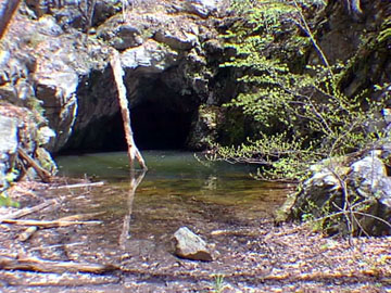 |
| Figure 39. Blue Mine, an abandoned magnetite mine in Norvin Green State Park. |
The trail to Blue Mine turns westward and climbs steeply over a half mile to a barren hilltop of foliated gneiss. This glacially scoured hilltop at 970 feet in elevation provides a commanding view of the valley to the north. Around this hilltop pitch pines are gradually establishing hold, gradually transforming the weathered regolith into a suitable soil for other evergreen shrubs and deciduous plants to take hold.
| Return to the Highlands Province Main Page. |