7. Staten Island Serpentinite
Todt Hill on Staten Island is the highest point along the Atlantic Seaboard south of Maine. The highest point, 410 feet above sea level, is located just south of the intersection of Todt Hill Road with Ocean Terrace (Figure 24). "Todt" is a Dutch word meaning "dead." This hill probably received its name from the Dutch settlers because the hilltops overlooking the Verrazano Narrows consisted of scattered treeless rocky exposures. The chemical character of the bedrock was, in part, the reason for this. Much of Staten Island is covered by the Harbor Hill moraine, the terminal moraine of the last Wisconsin Stage glacier. However, ledges of bedrock consisting of serpentinite are exposed throughout the upland areas on Staten Island. Serpentine, the dominant mineral in serpentinite, is rich in magnesium, an element that most plants cannot tolerate in high concentrations. The enrichment of magnesium in the thin soil covering the glacier-scoured hilltops is probably responsible for the original barren exposures on Todt Hill.
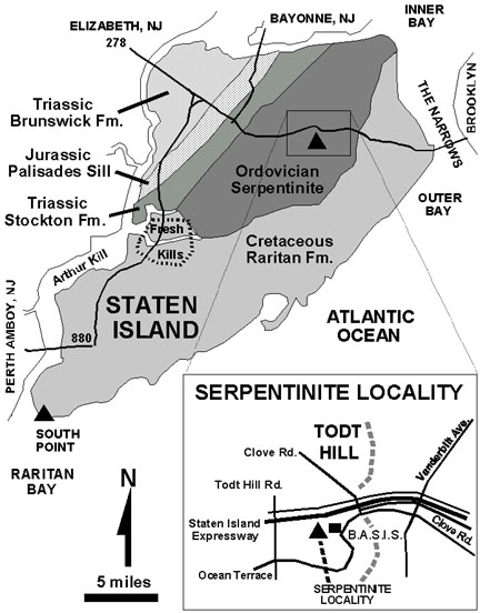 |
| Figure 24. Generalized geologic map of Staten Island showing the location of the Serpentinite locality along the Staten Island Expressway (located near Brooklyn and Staten Island Schools, formerly the campus of the College of Staten Island) (map after Lyttle & Epstein, 1987). |
The serpentinite has a bluish to greenish gray color, and consists of serpentine (mostly the variety antigorite), with accessory minerals of chrysotile (a form of asbestos), magnetite, and talc. Serpentinite is derived by the metamorphism of ultramafic rocks (rocks rich in the minerals olivine and pyroxene) in a water-rich environment. The probable original setting for these rocks was within the igneous crust beneath the Iapetus Ocean. The occurrence of serpentinite in the core of Staten Island is an indication that the allochthonous basement rocks consisting of oceanic crustal material were thrust landward onto the eastern margin of the continent during the Taconic Orogeny. The occurrence of serpentinite is consistent with the interpretation that Staten Island is east of Cameron's Line.
Along the eastern side of the Staten Island Expressway is a road cut for an abandoned highway interchange (Figure 25). The road cut is on undeveloped public lands adjacent to the old campus of the College of Staten Island, now the headquarters of BASIS (Brooklyn and Staten Island Schools). The land is not posted, however it is generally inaccessible without permission from BASIS. A loosely chained gate at the back of the BASIS parking area is the only public access to this land. Care should be taken when walking along the steep, undeveloped trails to reach the abandoned road cut. Many old, rusted and burned out vehicles lie abandoned along the trails, adding to the surreal and hazardous character of this locality. It is wise to stay well away from the northern end of the outcrop where it is well within sight of the Staten Island Expressway. In addition, the road cut itself is quite steep, and the highly fractured character of the sepentinite makes it hazardous to climb. The rock displays a brownish-gray, clay-rich residue on most weathered surfaces. The base of the road cuts are littered with large blocks of serpentinite which tumble down after the freeze-thaw cycles in the winter.
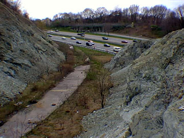 |
| Figure 25. Exposure of the serpentinite in an abandoned highway cut adjacent to the Staten Island Expressway. |
The road cut was built as part of a Robert Moses dream to make a more direct connection between the Verrazano Narrows Bridge and Richmond Parkway extending from the Outerbridge Crossing. The highway construction was blocked by a grass roots effort to preserve the green belt along the crest of Staten Island.
| Return to the Highlands Province Main Page. |