21. Round Valley State Park
Round Valley State Park consists of 5,300 acres of forested hillsides surrounding Round Mountain Reservoir. The reservoir covers over 4,000 acres and is over 180 feet deep (the deepest lake in New Jersey). The western portion of the park is a recreation area that charges day use fees during the summer months. Camping is available in back country sites accessible by hiking, canoe, or by boat (no car camping). A system of trails along the western shoreline provide scenic views of the lake and surrounding hillsides. Round Valley Recreation Area is located off I-78 at exit 20-A. Follow Route 22 about a mile west and turn left (south) on County Route 629. The entrance to the park is about two miles up the hill on the left. A map and information are available at the park visitor center.
Round Mountain Reservoir is the state's second largest reservoir (after Hopatcong Reservoir), and is managed by the New Jersey Water Supply Authority. The construction of the reservoir took six years and was completed in 1965. The lake has two dams: South Dam straddles Prescott Brook, and North Dam and Dike were built to contain South Branch Rockaway Creek at its northwestern end. A smaller dike was built across a stream drainage along the western end of the lake to support a swimming area for the park's recreation facilities. Besides the two streams, the full reservoir level is maintained by sometimes pumping water uphill about 3.3 miles from the South Branch of the Raritan River.
Round Valley (now flooded) is surrounded on the north, east, and south by Cushetunk Mountain, a U-shaped ridge ranging from about 400 to 830 feet in elevation. The mountain is the erosion-resistant remnant of a great diabase dike that intruded into the sediments along the western margin of the Newark Basin. The earth-filled dam and dike are covered with rip-rap boulders of this diabase. Both dams of Round Mountain Reservoir were built straddling the Flemington Fault, the eastern boundary fault that defines the border between the Reading Prong (New Jersey Highlands) and the central southern portion of the Newark Basin. Not to worry though, the design engineers did their research and filled the faults with grout before they built the earthen dams.
Rocks of Precambrian and Early Paleozoic age crop out in the vicinity of campground and picnic areas and along the hillsides to the south and west of the reservoir. Exposures of amphibolite gneiss surface along the shore east of the Campers Boat Launch parking area. Pink granite is exposed along the shore of the reservoir south of the small impoundment dike separating the swimming beach from the main lake (Figure 49). This granite is a late Precambrian intrusion into the older amphibolite gneiss. This outcrop can be accessed by following the Pine Tree Trail or any of several unmarked trails along the shore of the lake south of the swimming area. It can also be accessed by parking at the Boat Launch on Route 629 and walking southward across an impoundment dike that separates the swimming area from the reservoir.
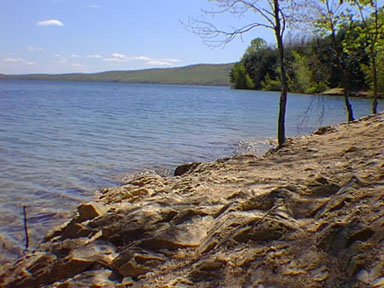 |
| Figure 49. Late Proterozoic granite crops out on the western shore of Round Valley Reservoir. Cushetunk Mountain, a large, semicircular Jurassic diabase intrusion into the Triassic sediments of the western Newark Basin forms a U-shaped ridge that surrounds most of the lake on its eastern end. |
| Return to the Highlands Province Main Page. |