Interstate 78 Through The New Jersey Highlands
One of the best escape routes from the city is the Holland Tunnel.(Completed in 1927, it was named after an Engineer, C. F. Holland, not the Dutch country!) At its western end you resurface in Hoboken, New Jersey. If civilization still exists, hopefully you won't have to endure a line of traffic on the New Jersey Turnpike Extension across Newark Bay into Newark. After paying alms to the toll engineer, you hop onto I-78 and, hopefully, leave the traffic behind.
The drive west along I-78 across New Jersey is one of the most exceptional highway geology tours of North America. The roadside exposures change from mile to mile. (However, please don't plan to stop along the Interstate! Accidents are called "accidents" for good reason! Plan time to look at stops at exits along the way.) From its terminus at the Turnpike in Jersey City, the next 35 miles of highway cross the igneous ridges and sedimentary valleys of the Newark Basin (see Chapter 4 on Mesozoic Basins). The interstate crosses the valleys of the Passaic and Raritan Rivers. Just east of Exit 18 (Clinton, NJ) the interstate leaves the Newark Basin and enters the Highlands of the Reading Prong. The next fifteen miles includes some of the most complex geology in the region. The road crosses sections of folded and faulted Precambrian rock, early Paleozoic sedimentary rocks, and additional outlier patches of Newark Basin rocks. Near exit 7 the interstate climbs Musconetong Mountain then drops into the Great Valley, a region underlain by complexly folded and faulted Early Paleozoic sedimentary rocks typical of the Valley and Ridge Province.
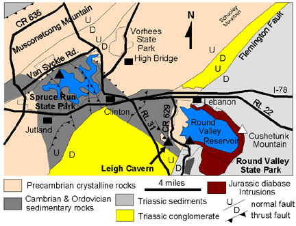
Two public sites near I-78 where rocks and geologic structures of the Highlands can be examined include exposures in and around Round Valley State Park and Spruce Run State Park (Figure 48).
 |
| Figure 48. Generalized geologic map of the New Jersey Highlands along I-78 (after Drake et al, 1996). |
| Return to the Highlands Province Main Page. |