Mesozoic Basins
During the Late Paleozoic all of the continental land masses assembled into a single supercontinent, Pangaea (Figure 83). The region that would eventually become the east coast of North America was at the heart of this great landmass, and was located within the equatorial realm. During the climax of the Alleghenian Orogeny, the Appalachians were probably high, rugged mountains rivaling the modern Alps. However, as mountain building subsided at the end of the Paleozoic Era, tropical weathering and erosion eventually reduced the landscape to a low, rolling plain. Ancient river systems carried the sediment far away to basins on the continental interior of the North American Plate, and to distant shorelines around the great landmass. Pangaea held together for nearly 100 million years.
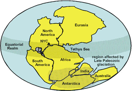 |
| Figure 83. Generalized reconstruction of the supercontinent, Pangaea in latest Paleozoic time. |
Starting around Late Triassic time (about 220 million years ago) Pangaea began to gradually break apart. A great rift system developed along the suture zone between the continents of Africa and North America.. Part of this expanding rift system would eventually become spreading center of the modern Atlantic Ocean (Figure 84). In its early stages, the rift system probably had characteristics similar to both the modern East African Rift Valley and the Great Basin region of western North America. These regions feature multiple block-faulted uplifts adjacent to sediment-filled half graben-type valleys, along with a scattering of volcanic centers. Triassic age uplifts and grabens formed all along the Atlantic margin; remnants of these basins and volcanic centers occur scattered from Alabama to Newfoundland. Based on geophysical exploration, other rift basins are inferred to exist beneath the sedimentary cover of the coastal plain and continental shelf. Many of these grabens formed along preexisting fault systems that had formed during the orogenies of the Precambrian and Paleozoic. Whereas multiple graben valleys formed between the continents, only one continued to widen to eventually become the Atlantic Ocean. The other valleys became "aborted rifts," filling completely with alluvial and lacustrine sediments, and with both intrusive and extrusive volcanic rocks (chiefly diabase and basalt). Figure 85 illustrates the three Mesozoic basins in the New York Bight region: the Newark Basin, the Connecticut River Basin, and the Baltimore Canyon Trough (a massive basin offshore along the eastern margin of North America that is still receiving sediments). Figure 86 shows the generalized stratigraphy of the Mesozoic basins in the New York Bight region.
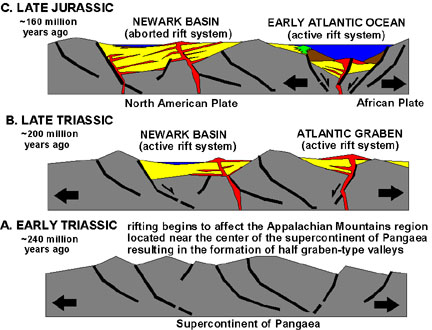 |
| Figure 84. The breakup of Pangaea and the formation of the Mesozoic rift basins. |
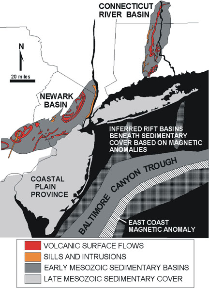 |
| Figure 85. Location map of Mesozoic basins in the New York City region (modified after highway map by the American Association of Petroleum Geologist, 1995). |
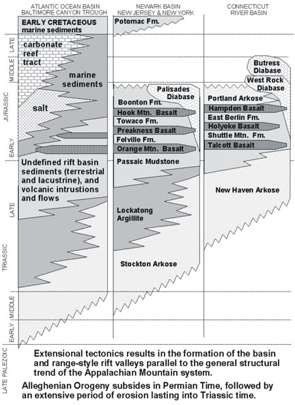 |
| Figure 86. Generalized Triassic and Jurassic stratigraphy of the New York City region (after Drake et al., 1996, Fisher et al., 1995, and Rogers, 1985). |
The Newark Basin (in New Jersey, New York, and Pennsylvania) and the Connecticut River Basin are both "aborted rift" basins (rift basins that are no longer actively widening via rift-style tectonism and are no longer collecting sediments). Sediments began to accumulate in both basins during the Late Triassic. Both basins are half grabens which contain characteristic sedimentary conglomerates, sandstones, and mudrocks that usually bear a red or brownish appearance from an abundance of iron oxide minerals (chiefly hematite and limonite). (Homes built of stone from the Newark Basin are called "brownstones."). These rocks represent sediments deposited concurrent with the movement of the border faults, the large normal faults that created the half-graben structures (see Figures 84). The raised foot wall of the border faults became the rugged mountainsides that shed sediments into the adjoining basin areas. Along the border fault large alluvial fans accumulated. These deposits, called fanglomerates, consist of coarse sand to massive boulders cemented in a fine, iron-rich matrix.
Towards the center of the basins, the coarser material vanishes, and the sediment consists of evenly-layered fine-grained sandstone, mudstone, and shale. Repeating sedimentation patterns in the thick sequence of strata within the basins reveals that long-term fluctuations in the climate played an important role in the distribution and character sediments. At times, the climate was wetter, so large lakes expanded to nearly fill the entire basin. During extended dry periods, these lakes dwindled in size, or vanished. The dry lake beds became alluvial plains with migrating stream channels. Evidence for these cyclic changes, ranging in the order of 10,000s to 100,000s years are recorded by both the character of the rock and the fossils they preserve. Although fossils are not abundant, early Mesozoic dinosaur skeletons and trackways have been discovered. Freshwater shell material and poorly preserved fish and plant remains are also found in some areas.
Both the Newark and Connecticut River Basins contain "traprocks." The word, traprock, is derived from the Swedish word "trappa," meaning stair or step. In the mining usage, a traprock is any fine-grained igneous rock, usually diabase or basalt, that can be crushed for building or road aggregate. Erosion creates their step-like appearance, producing abrupt termination of successive volcanic flows. During Early Jurassic time, episodic rift-basin-style volcanism began to occur. Magma of basaltic composition migrated from the upper mantle to the surface along faults. Massive volcanic eruptions at the surface resulted in the formation of surface flows that spread for great distances across the low relief of the alluvial basins. After volcanism ended, the flows were buried beneath the more gradual accumulation of basin sediments. Because of the half-graben structure of these basin, the originally horizontal volcanic flows are now gently inclined. The resistance of traprocks to erosion (relative to the surrounding sandstone and shale) results in the formation gently dipping cuestas throughout the Mesozoic basins all along the Atlantic margin. Within the Newark Basin, the Watchung Mountains are examples of traprock cuestas. The ridges of resistant volcanic rock of the Palisades and the Watchung Mountains display steep escarpments on their eastern flanks and gentle slopes on their western flanks. This is an indication of the gentle dipping character of the strata towards the deeper western side of the basin. When the sediments were originally deposited there were probably nearly flat-lying. The structural dip of the rock probably developed as the basin continued to grow through time, even long after the youngest sediments of the basin were deposited.
Field Trip Destinations
The Mesozoic age rocks in the New York City region provide some of the best rock, mineral and fossil observation destinations anywhere on Earth. A well-planned, early start from anywhere in the New York City region can take you to places that are worthy of "international heritage sites" that rival any location on the globe. Discussions below include:
Newark Basin39. The Palisades
40. Paterson/Great Falls Area
41. Interstate 280 Road Cuts
42. South Mountain Reservation
43. Watchung Reservation
44. Riker Hill Park
45. Delaware River Valley Scenic Route
Connecticut River Basin
46. Dinosaur State Park
47. The Hanging Hills
48. New Haven
Baltimore Trough and the Atlantic Basin
| Continue to the Coastal Plain Province. |