The Connecticut River Basin
The Connecticut River Basin is the geologic feature that defines the extent and character of the Central Valley of Connecticut (Figure 105). The Connecticut River Basin formed concurrently with the Newark Basin (of Mesozoic age). The similarity of the sediments and the composition of the volcanic rocks raise questions as to whether these two basins may have at one time been connected, but separated by a later stage of regional folding, uplift, and erosion. In any case, the stratigraphy of the two basins is remarkably similar (see Figure 86 on the MesozoicBasin page). However, the structure of the two basins are inverted to one another. The strata of the Connecticut River Basin dips eastward toward the border fault along the eastern margin of the basin (Figure 106).
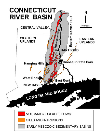 |
| Figure 105. Map of the Connecticut River Basin (after highway map by the American Association of Petroleum Geologists, 1995 and Rogers, 1985). |
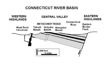 |
| Figure 106. Cross section of the Connecticut River Basin. |
The eastward dipping basalt "traprock" formations form a series of hilly to mountainous ridges that form a topographic spine along the axis of the basin. Metacomet Ridge is the name given to these traprock cuestas within the Central Valley region. Throughout the eastern part of the basin are numerous diabase intrusions. The largest of these is the West Rock ridge that rises over 600 feet above sea level north of New Haven, Connecticut. Other diabase sills of Jurassic age occur within the Eastern and Western Highlands regions bordering the Central Valley (see Figure 105).
The continental glaciers of the Pleistocene complete overrode the Connecticut landscape, scouring way the softer sedimentary rocks, leaving the behind the more resistant portions of the volcanic sills and intrusions. Prior to the continental glaciation, coastal plain sediments probably extended northward into portions southern Connecticut. However, as the ice advance southward this sedimentary cover and the surface of the underlying bedrock were scoured away. Long Island Sound is, in part, a flooded valley carved where coastal plain material was carried away and dumped in the moraines and outwash deposits that form the surficial deposits of Long Island. Basalt, diabase, and red bed sandstones from Connecticut are abundant in the glacial deposits exposed along the north shore of Long Island.
Although it is a fairly long drive to visit Connecticut's Central Valley from New York City, the trip offers many scenic rewards. The best time to go is during the fall foliage or in the late spring before the tree leaves completely mask the landscape. Anyone interested in dinosaurs needs to make a pilgrimage to the exceptional dinosaur museums in Connecticut. A recommended day trip would be to visit the museum at Dinosaur State Park in the morning, then plan a picnic and hike at a regional park, such as the hike to Castle Craig at the Hanging Hills area near the town of Meriden, Connecticut. Another trip option would be to combine it with a visit to the Peabody Museum. However, a day trip to the New Haven area is worthy of itself!
| Return to Mesozoic Basins Province. |