47. The Hanging Hills
The Hanging Hills are a 1,000 foot high broken escarpment of traprock
where Metacomet Ridge bends eastward across the Central Valley just north
of Meriden, Connecticut (Figure 108). Scour by moving glacial ice has
plucked away the basalt from the steep southern end of the crest of the
broken ridge, creating the overhanging cliffs. These scenic mountainsides
north of Meriden are a nature preserve, watershed area, and parkland (Hubbard
Park). Castle Craig is a small stone tower built in 1900 on the mountain
top overlook on East Peak (Figure 109). The tower is a popular destination
of a two-mile hike to the ridge top. During the summer it is sometimes
possible to drive to the top of the ridge when the gate is not locked.
Perhaps an even better view is possible from a slightly higher higher
overlook at the southern tip of West Peak. (This overlook area is along
the trail just east of a radio tower parking area). The views from either
of the overlooks are extraordinary. From the top of the ridge on a clear
day it is possible to see most of the Central Valley region, Long Island
Sound, and the distant higher peaks of the highlands throughout southern
New England (Figure 110).
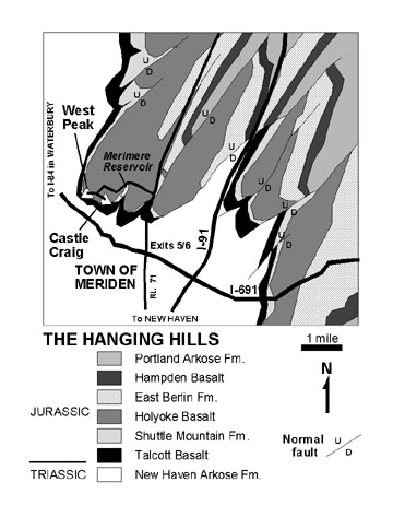 |
| Figure 108. Geologic Map of the Hanging Hills area near Meridan,
Connecticut showing the location of West Peak and Castle Craig overlooks
(modified after Drake, 1985). |
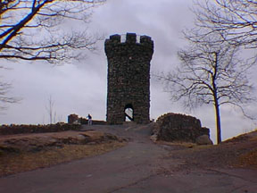 |
| Figure 109. Castle Craig Tower overlook in the Hanging Hills near
Meridan, Connecticut. |
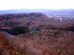 |
| Figure 110. Eastward view of the Merimere Reservoir and the escarpments
of the trap rock basalts of the Connecticut River Basin in the Meriden,
Connecticut area. |
Hubbard Park is a city park of Meridan that encompasses part of the Hanging
Hills. From Interstate 691 take Exits 5 or 6 and follow the signs for
CT Route 71 north. A little more than a mile north of the interstate,
Butler Street branches to the left. Follow Butler Street about a few hundred
yards and turn left onto Park Road. Park Road dead ends in about a mile
at a barricade at Merimere Reservoir. Park here and walk westward across
the bridge, then follow the road up hill. The walk up the mountain is
challenging climb over 500 feet.The road splits near the top of the hill.
The less traveled road to the right leads to the radio towers and overlook
area on West Peak. The road to the left leads to Castle Craig and the
picnic area by the tower on East Peak. The Metacomet Ridge Trail circles
the southern crest of the Hanging Hills. When the trail is dry it is a
scenic alternative route to return to the parking area. From Castle Craig
the trail descends steeply eastward from East Peak to the western shore
of Merimere Reservoir.
The cap rock of the Hanging Hills escarpment is the massive Early Jurassic
Holyoke Basalt; it is nearly 700 feet thick. The exposures along the ridge
tops display an irregular polygonal columnar jointing pattern that formed
as the massive volcanic surface flows gradually cooled. Most of these
fractures are tightly cemented by minerals that formed long after the
flows were buried by younger sediments. The tell-tale grooves and scratches
from rocks embedded in the bottom of the glacier are still visible in
patches on the barren bedrock along the cliff tops. The Early Jurassic
Shuttle Mountain Formation (red beds) and the Talcott Basalt crops out
along the forested hillsides at the base of the ridge. In the Meriden
region, numerous northeast-trending normal faults offset the volcanic
flows and intervening sedimentary rocks. Several of these faults break
the Metacomet Ridge north of Meriden. Stream erosion and glacial ice carved
canyons along these faults, dividing the ridge into the finger-like promontories
of the Hanging Hills (West Peak, East Peak, South Mountain, and Cathole
Mountain, west-to-east respectively.). Merimere Reservoir was built in
the fault-controlled valley between East Peak and South Mountain.
|