48. New Haven, Connecticut
A field trip to Connecticut would be incomplete without a pilgrimage to the Yale Peabody Museum in downtown New Haven, Connecticut. The museum's star attraction is the "Great Hall of Dinosaurs" which displays Othniel Charles Marsh's Triceratops, Stegosaurus, and controversial "Brontosaurus," and the great mural, The Age of Reptiles, by Rudolph F. Zallinger. Equally impressive is the "Hall of Mammalian Evolution" which features Zallinger's other mural, The Age of Mammals. The museum also exhibits artistic nature dioramas and displays featuring plant fossils, meteorites, primates, mammals, and a regional minerals, as well as classic collections featuring Ancient Egypt, and peoples of the Ancient Americas.
To get to the Peabody Museum take Exit 3 off Interstate 91 onto Trumbull
Street connector, and follow the signs to the museum located on the corner
of Whitney Avenue and Trumbull Street. The museum is open daily 10am to
5pm, noon to 5pm on Sunday (closed major holidays). Parking and admission
fees are charged.
The city of New Haven developed around a natural bay in the Connecticut
shoreline where the Central Valley meets Long Island Sound (Figure 111).
The Pleistocene glaciers helped carve away the softer sedimentary strata
of the Connecticut River Basin, creating valleys between the higher, more
erosion-resistant volcanic rocks that crop out in the Central Valley and
the older metamorphic rocks of the surrounding Highlands. To the north
and west of downtown New Haven is West Rock Ridge State Park, a park encompassing
a great Jurassic diabase sill that intruded into the Late Triassic red
beds. To the north of downtown, volcanic intrusions of Jurassic age crop
out along the West River and Quinnipiac River valleys. These volcanic
escarpments are responsible for the scenic landscape preserved in East
Rock State Park and nearby Sleeping Giant State Park (located about 8
miles north of New Haven). Hilltop overlooks in any of these parks provide
exceptional views of the Central Valley, the southern end of Metacomet
Ridge to the east, mountainous uplands in the surrounding Eastern and
Western Highlands regions, and an expansive view Long Island Sound.
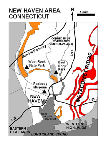 |
| Figure 111. Geologic map of the New Haven area (modified after Rogers, 1985). Red and orange are ridges from volcanic flows; white is regions underlain by sedimentary rocks of Triassic and Jurassic age; gray are older Paleozoic and Precambrian age rocks. |
West Rock Ridge is the most prominent physiographic feature in the region around New Haven, Connecticut. It rises to over 600 feet and extends for nearly 15 miles along the eastern side of the Central Valley. A six mile portion of the ridge is protected in West Rock State Park. The park is host to many miles of scenic hiking trails. The most popular hike is a two-mile walk along a park road (usually closed to traffic) that leads from the valley to overlooks on the top of the ridge. A short spur trail leads to Judge's Cave, an small enclosure created by huge cracks in a massive glacial erratic. The cave served as a hideout for two famous colonialists, Judges Whalley and Goeffe, who were being pursued by British troops for signing a death warrant for the Charles I, King of England. This huge erratic, along with other massive boulders in the area, were transported by the glaciers to this location from the Hanging Hills area many miles to the north. To get to West Rock State Park from downtown New Haven, follow Route 10 (Dixwell Avenue) north. Turn west on Benham. Turn south onto Main Street, and then west onto Wintergreen. Park at the West Rock Nature Center just north of the park entrance. The park road is sometimes open to cars during the summer and early fall.
East Rock Park encompasses another remnant of the massive diabase intrusion that formed West Rock Ridge. Although not as high (359 feet), the regional view from the top of East Rock is quite impressive. A park road to the Civil War and Sailors Monument at the summit is open most of the year. To get there, take Interstate 91 north to Exit 3. Turn left onto to Trumbull Street. Proceed west about two blocks and turn right onto Orange Street. Follow Orange Street north about 14 blocks and cross the bridge into the park. Bear left to drive to the summit.
| Return to Mesozoic Basins Province. |