The Baltimore Canyon Trough
The Baltimore Canyon Trough is a great sedimentary basin that exists offshore beyond the shallow depths of the inner New York Bight (Figure 112). The axis of the basin runs roughly parallel to the coastline from offshore North Carolina to the eastern tip of Long Island with its greatest accumulation center located about 20 to 30 miles offshore from Atlantic City, New Jersey. This massive basin consists of up to 14 kilometers of sediment above basement crustal rocks. The transitional boundary from continental crust to oceanic crust is inferred to correspond to the East Coast Magnetic Anomaly, a region of strong magnetic variation that roughly parallels the edge of the Atlantic continental shelf (see Figure 85 on the Mesozoic Basins page).
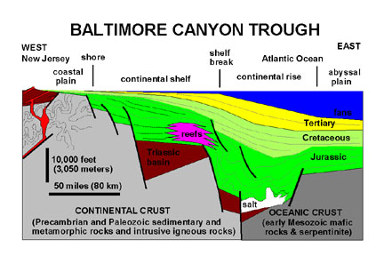 |
| Figure 112. Generalized cross-section of the offshore region of central New Jersey showing hypothetical geologic features of the Baltimore Canyon Trough. Note horizontal and vertical scales (after Sheridan, 1989). |
Whereas the Newark Basin rift system became relatively inactive by Late Jurassic time, the Atlantic Basin continued to grow progressively wider, eventually becoming the Atlantic Ocean basin as it exits today. Seismic reflection profiles suggest that the deepest portion of the basin is probably terrestrial in origin, similar to the Mesozoic basins on land. Fluvial-lacustrine sediments with basalt flows and intrusions probably accumulated to great thickness, forming concurrently with other Mesozoic basins at the time of the breakup of Pangaea. This massive wedge of sedimentary and volcanic rock straddles the transitional continental/oceanic crust boundary. In the early stages of marine flooding in Latest Triassic time, the Atlantic Basin was probably quite similar to the modern Red Sea. The terrestrial sequence of the Triassic is overlain by massive accumulations of salt. (The Early Jurassic Argo Salt is thought to occurs throughout very deep portions the basin; this salt has migrated upward through younger sediments as salt diapers that reach in places to within five kilometers of the sea bed.)
During Early Jurassic to Early Cretaceous time carbonate deposition prevailed along the shelf margins of the ever-widening ocean basin. The Jurassic sea was warm enough to generate a great carbonate platform with reef tracts, similar in character to the modern Florida or Bahamas shelves. Like these modern carbonate platforms, the Jurassic platform along the Atlantic Margin was quite shallow for many miles from shore, but broke away steeply to great depth along the outer shelf margin. Shoreward, the sediment was dominantly marl in composition where carbonate material mixed with sediment derive from land Eventually, at this platform matured, great listric growth faults began to develop within the sedimentary sequence. These faults formed roughly parallel to shore; they are steep near the surface but grow progressively to a shallower angle at depth, and probably have no relation to the older faults in the crustal basement. Movement of these faults broke up the carbonate platform into great blocks which rotated gradually as more and more sediment spilled into the basin. This dipping strata exposed along the crests of these great blocks of platform material were eventually deeply buried by the progressive buildup of a thick wedge of younger clastic sediments. Experience from petroleum exploration suggested that these blanketed block-faulted structures make ideal petroleum reservoirs, however exploratory drilling of these structures in the 1980s proved unsuccessful for two reasons. First, in the limited amount of drilling conducted in the region no significant oil and gas reservoirs were found, or not at least disclosed to the public's attention. Secondly, at this time environmental concerns far outweigh the need for local production.
By Early Cretaceous time, regional river drainage systems began to expand westward from the coastal margin, and the carbonate platform areas were eventually smothered by an ever increasing supply of clastic sediment. River systems that developed during the Jurassic expanded their headlands far inland, and by Early Cretaceous time the contribution of clastic material onto the Atlantic Margin far outweighed the contribution of carbonate sediment buildup that dominated during the Jurassic.
By Late Cretaceous time there was a steady but significant rise is sea level around the world (probably driven by massive, long-lasting volcanism events throughout the South Pacific region and elsewhere). This period of geologic time is referred to as the "Greenhouse Earth" in that global temperatures were much warmer. Sea level was also much higher (as much as 100 meters higher relative to modern sea level). With rising sea level, shallow marine seaways flooded the margins and interiors of continents around the world. During the Late Cretaceous, the shallow waters of Atlantic Ocean shelf extended far inland of its current configuration. The location of our modern shoreline would have been about midway between the Cretaceous shoreline and the shelf break of the outer continental shelf. The significance of this gradual shelf profile is addressed in detail in the next chapter.
| Return to Mesozoic Basins Province. |