Atlantic Coastal Plain
In the New York City region, the Atlantic Coastal Plain encompasses Long Island, a small portion of Staten Island, and all of southern New Jersey (Figure 113). The region is underlain by poorly consolidated sedimentary formations of Cretaceous, Tertiary, and Quaternary age that gently dip seaward. In New Jersey, the plain is subdivided into three sub provinces: the Inner Lowland (encompassing the low, broad valley along the Delaware River estuary), the Outer Lowland (along the southern New Jersey shore), and the Central Upland (encompassing an area of relatively low relief).
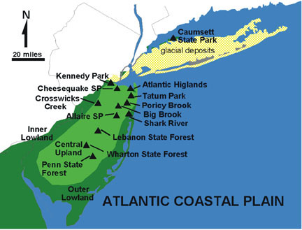 |
| Figure 113. Map showing field localities on the Atlantic Coastal Plain of New Jersey, Staten Island, and Long Island. Light green shows the rolling hill country of the Central Upland region. Dark green indicates the Inner and Outer Lowlands region (dominated by coastal estuaries, swamplands, and low relief near sea level). The yellow stippled pattern indicates the region covered by the Late Pleistocene (Wisconsin) glacier (discussed in the next chapter entitled Glaciers of the Quaternary). |
The first two regions lie between elevations of sea level to about 50 feet, and are underlain by Pleistocene and Holocene glacial outwash and fluvial sediments. The Uplands region incorporates some low, hilly escarpments, with elevations ranging roughly from 50 feet to a maximum of 373 feet on Beacon Hill in Monmouth County, along the north west margin of the New Jersey coastal plain. In the Central Upland, Cretaceous and Tertiary sedimentary rocks are exposed at the surface or are covered by a thin veneer of Pleistocene fluvial sediments. Tertiary ironstone conglomerate forms the caprock of low hills and ridges in this region. The highest escarpment forms the Atlantic Highlands on the southern shore of Raritan Bay. This line of hills can be easily seen throughout the Outer New York Harbor.
The boundary between the coastal plain and Newark Basin (Piedmont) is a broad, shallow lowland, less than 80 feet above sea level, extending from Raritan Bay to the Delaware River. This long, low swale follows the trace of the western edge of Cretaceous sediments that onlap onto the rocks to the Newark Basin. This broad, low valley is covered with a thick veneer of alluvial deposits associated with rivers that flowed southward to the Delaware River Valley when the northern drainages were blocked by glacial ice and moraines.
Expansive forests, dominated by pitch pine, occur in both New Jersey and Long Island where surficial deposits consist of permeable sand of Miocene to Holocene age. These forests, called "pine barrens" cover much of the Central Upland in New Jersey. They are also well developed on the sandy outwash plain of central western Long Island and on undeveloped stretches of the bay sides of barrier islands of the Atlantic shore.
Long Island and the southern and eastern shores of Staten Island are also part of the coastal plain. However, in addition to being underlain by Cretaceous sediments the surface deposits consist dominantly of massive moraine and outwash from the Pleistocene continental glaciers (discussed in the next chapter). In a geologic perspective, the coastal plain is continuous with the shallow continental shelf extending from the shoreline seaward to the break in slope along the outer continental shelf. Bathymetry of this region shows that this expansive shallow offshore region has even less relief than the landscape of the coastal plain!
The stratigraphy of the Atlantic Coastal Plain records a story of 100 million years of transgressions and regressions of seas across the region. Shoreline migrations were driven by major changes in sea level. The rise and fall in the recent geologic past were directly related to the build-up and melting of continental glaciers. However, the causes in the distant past are still unclear. Current theory suggests that Earth was too warm for glaciers to develop during the Late Cretaceous (as inferred by the presence of "warm climate" fossils at high latitudes). Other mechanisms may have been the cause, such as major, long-lasting volcanic events, great pulses in tectonism, or the after-effects of massive comet or asteroid collisions with Earth. Whatever the cause, cyclic oscillations controlled the occurrence (and distribution) of sedimentary material on the Coastal Plain. Erosion and tectonic submergence prior to Late Cretaceous time had probably reduced the topography of the Atlantic Coastal Plain and the Appalachian Mountains to a broad, low plain near sea level. During the most significant transgression during the Late Cretaceous (between 95 and 90 million years ago), sea level was as much as 300 feet higher than present. Imagine waves crashing against the cliffs of the ancestral Watchungs or Palisades! Long Island would probably not have existed, and the sepentinite core of Staten Islands could have been an island far offshore! Unfortunately, it is unknown exactly how far inland the seas may have invaded.
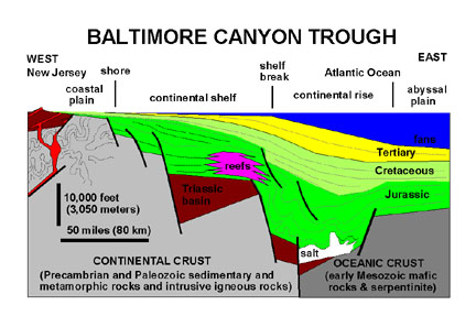
The term "passive margin" is used to describe the current character of the Atlantic side of the continent. In contrast, the Pacific coast is an "active margin" where major tectonic upheaval is progressing as a result of crustal plate collisions, and oceanic crust subduction. North America is gradually moving in a northwest direction as the Atlantic Ocean continues to expand along the Mid Atlantic Ridge spreading center. In this "relative motion" scenario, the Atlantic margin may be considered the trailing edge of the continent. Along the Atlantic margin, the boundary between continental and oceanic crust are locked together, causing the two regions to behave as a single crustal plate. As the continental shelf develops along the Atlantic margin matures, it slowly subsides. This process is driven by several factors: 1) the continued cooling and condensing of the new crust beneath the margin of the continent; 2) the gradual isostatic readjustment of the crust to the additional weight of sedimentary deposits accumulating on the margin; and 3) the gradual dewatering and porosity reduction of the sediments. As a result, the sedimentary formations exposed on the coastal plain and in the subsurface offshore gradually dip southward toward the central basin area of the Baltimore Canyon trough located far offshore from Atlantic City (see Figure 112). One hundred million years of sediment accumulation on the Atlantic continental margin has resulted in the build-up of a great wedge of material, consisting of a stacked sequence of sedimentary rock formations that pinch out landward and thicken seaward. The total sequence of sedimentary materials deposited since Jurassic time approaches 30,000 feet in thickness near the break in the continental slope (about 70 miles offshore from New Jersey).
During the Late Tertiary were periods when global sea level fell significantly, driven, in part by the buildup of massive glaciers in Antarctica, and later by continental glaciers in the Northern Hemisphere. When sea level fell, the shelf areas were filled in by prograding sequences of sands and gravels, partly at the expense of older sedimentary deposits exposed along the expanding coastal plain. In this manner, the redistribution of materials seaward extended the continental shelf to its present location. The movement of sediment from inshore regions to areas far offshore occurs as a result of wave energy and currents (particularly during giant storms) redistributing the coarser sediments across the sea bed. These currents winnow the finer sediments upward into the water column to be carried in suspension for great distances. Beyond the shelf break, sediments spill downhill over the gradual incline of the continental slope. Disruption to Transatlantic communication cables demonstrate that sediments from the continental slope move down to abyssal depths as great slumps and turbidity currents. When sediments are churned into seawater, the density of this muddy mixture is greater than that of the surrounding seawater. Driven by gravity, this sediment-laden water rushes down slope. It scours the sea bottom along the way, churning up additional sediment, while building greater momentum. When the turbidity current reaches the deep sea basin, it gradually diminishes intensity, the this "undersea storm" can spread for hundreds, even thousands of kilometers across the sea floor, blanketing an entire region with a layer of sand, silt, and clay sediments.
During periods when sea level was low, streams carved downward into their flood plains, creating canyons or gorges; sediments were shuttled far out onto the coastal margin concentrating the materials near the mouths of rivers which were close to the shelf break. The movement of sediment downslope carved great submarine canyons, such as the Hudson Canyon, into the outer edge of the continental margin. The sediment pouring down these canyons and across the continental slope spread as broad fan deposits, building out as the continental rise at the base of the continental slope. During periods when sea level rose the sea transgressed landward; sediments accumulated in the newly submerged areas, cutting off the supply of sediment to the outer shelf. However, the submarine canyons that remain along the shelf margin preserve the sediment migration routes to the deep ocean basin.
As mentioned above, sea level fluctuated causing transgressions and regressions throughout Late Cretaceous time into the Tertiary. These cycles in sea level change left an imprint on the character of the sediments preserved on the coastal plain. When sea level was high in the Late Cretaceous and Early Tertiary, the middle and outer continental shelf regions were starved from the influx of sediments. During these periods, chemical sedimentation dominated offshore regions in the form of pelagic sediments (diatomite), and marl rich in shell material and grains of the mineral, glauconite. This greenish to black mineral tends to replace fecal material from invertebrates that lived on or within the sea bottom. When sea level was stationary or began to fall, sand from the nearshore regions was transported seaward by waves and currents, blanketing the older deeper water deposits. Cycles of repeated transgression and regression are repeated by numerous shaly marl and sandstone layers, each varying in their thickness and distribution depending on the duration of each cycle, sediment supply, and location. In many places, the story of sedimentation is represented by disconformities, an interface within a stratigraphic succession that represents an extended period of non-deposition or erosion (see Figure 8). On the coastal plain there are many disconformities representing tens to hundreds of thousands of years, and several major unconformities representing many millions of years. The character and extent of these unconformities varies from one location to the next. Figure 114 illustrates the generalized stratigraphic units and major unconformities on the coastal plain. Significant unconformities represent great drops in sea level that occurred several times in the Late Cretaceous, Paleocene, Late Eocene, and before the beginning of the Ice Ages during the Pliocene.
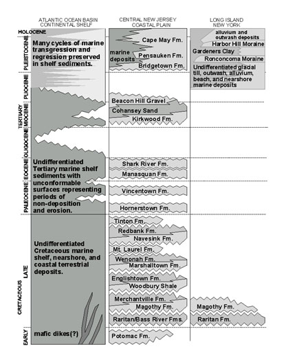 |
| Figure 114. Cretaceous and Cenozoic Stratigraphy of the Atlantic Coastal Plain in the New York Bight region (modified after Lyttle & Epstein, 1987 and COSUNA Chart by the American Association of Petroleum Geologists,1983). |
The last great high-stand in sea level began about mid-Miocene time (~15 million years ago) and lasted until in Latest Miocene to Early Pliocene time. The evidence for this last high-stand is represented by the extensive marine sand and gravel deposits that cover much of southern New Jersey (the Kirkwood and Cohansey Formations). These highly porous sands are the subsoil of the vast region extending from the Pine Barrens of southern New Jersey to the sandy hilltops in the Atlantic Highlands region. Ancient offshore sand and gravel deposits, barrier islands, beach ridges, and stream deltas add subtle relief to the pine-covered landscape. In the Pine Barrens of southern New Jersey, this marine and alluvial gravel deposits cap hilltops at elevations between 120-200 feet. In the Atlantic Highlands region, these deposits occur between 200-373 feet, uplifted to that height by the on-going processes of glacial rebound. In the region, these gravels are called the Beacon Hill Gravel, named for the locality of the highest point on the coastal plain in Monmouth County. The gravel of the Beacon Hill and from underlying formations have been reworked into younger stream flood plain deposits. Remnants of ancient flood plain deposits are preserved along Pleistocene-and-older terraces that occur as hilltops and hillside benches in the region. After mid-Miocene time sea level dropped significantly as global climates cooled, eventually resulting in the cyclic advance and melting of mid-latitude continental glaciers. As a result, sea level fluctuated wildly during the Pleistocene. The influence of glaciation on the geography of the New York Bight is discussed in the next chapter.
The fossils preserved in the sediments of the Coastal Plain record the advancement of modern species, as well as the dramatic extinction of many others. The Cretaceous/Tertiary boundary is preserved throughout the New Jersey region. Unfortunately, this famous boundary, marking severe devastation of marine fauna and the total extinction of the dinosaurs on land, is represented as an unconformity - a missing interval of time between layers of glauconitic marl above and below. However, evidence of an asteroid impact as the cause for the extinction event at the end of the Cretaceous is beginning to emerge in some locations along this boundary in New Jersey. Evidence for a "very bad day at the end of the Cretaceous" is recorded in the form fragments of rock-glass and shattered quartz grains ejected from a massive impact crater in the region of the Mexican Yucatán Peninsula, and possibly another in the Indian Ocean. Although perhaps not as extreme, other significant extinction events are represented in the younger formation boundary layers of the Coastal Plain. Whether these extinction events are a record of asteroid impacts or merely missing intervals of time in the sedimentary record will continue to be the focus of future research. One great impact structure was recently discovered in the vicinity of the lower Chesapeake Bay. Another large crater is possibly suggested by seismic reflection data approximately 60 miles offshore from Atlantic City. These craters are the probable source of tektites (impact ejecta) found in sediments of Late Eocene age (~35 million years ago) and in younger deposits throughout the Coastal Plain.
Sedimentary Formations of the Coastal Plain - this link provides discussions and illustrations of geologic features and fossils of the sedimentary units that underlie the Coastal Plain. The stratigraphy discussion is subdivide into unit of the Cretaceous, Tertiary, and the Quaternary. Selected field-trip destinations on the Coastal Plain include:
49. Sayreville/Kennedy Park
50. Cheesequake State Park
51. Atlantic Highlands
52. Poricy Brook
53. Big Brook
54. Tatum Park
55. Crosswicks Creek
56. Shark River Park
The Pine Barrens of New Jersey
57. Allaire State Park
58. Lebanon State Forest
59. Wharton State
Forest
60. Penn Forest
| Continue to Glaciers of the Quaternary. |