58. Lebanon State Forest
Lebanon State Forest was named after the local Lebanon Glass Works established in 1851. The manufacture of glass utilized the nearly pure quartz sand and wood charcoal resources of the area. The manufacture of glass ended around 1967 when all the accessible wood resources were exhausted. The forest has since become reestablished across the region. The state began acquiring property in 1908 to establish a managed forest for lumber production, public recreation, wildlife management, and water resource protection (see Figure 135 on the Pine Barrens page). The state forest currently covers about 32,000 acres, offering many miles of sand roads and hiking trails that lead through the woodlands. Sandy upland areas covered with pitch pine and oak forests, cedar swamps occur along streams, and an expanse of freshwater bogs have been modified for growing and harvesting cranberries and blueberries. The clean white sand exposed along the bogs, streams, and along the trails consists of remarkably pure quartz, derived from the underlying Cohansey and Kirkwood Formations (see Tertiary Stratigraphy). Traces of dark-colored heavy minerals can be seen in concentrated patches sorted and separated by running water. Just to the east of Lebanon State Forest is a heavy mineral separation operation that targets sand lenses which are concentrated with the minerals leucoxene and illmenite; both of which are enriched in titanium, an element that was particularly in demand during the Cold War.
The Batona Trail begins at a parking area at Ongs Hat on the northwest side of the forest (see Figure 135). Perhaps the most heavily traveled portion of the trail extends for two miles between a ranger station near the intersection of highways 70 and 72, and a camping and picnic area near Pakin Pond along the west side of the preserve (Figure 137). "Pakin" is the Lenape Indian word for Cranberry. Pakin Pond is an abandoned cranberry bog that is now a popular, scenic swimming hole. The water in the pond, in the creeks, and in the expanse of cranberry bogs to the east of Pakin Pond is a rich golden brown from the abundance of dissolved tannins and other organic compounds derived from the decay of pine needles and oak leaves. The Batona Trail between the ranger station and the pond follows the western border of Cedar Swamp Natural Area, a large swamp filled with a nearly impenetrable growth of American white cedar, and is a refuge for a variety of rare ferns, orchids and carnivorous plants (sundews and pitcher plants). It is interesting to consider that as recently as 12,000 years ago none of the species that currently live in the pine barrens existed here. During the maximum chill of the Pleistocene glaciation this region was probably a grassy tundra similar to the north slope of Alaska or Canada. Nearly all current species have migrated northward into the region in the past 10-12,000 years.
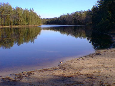 |
| Figure 137. A sandy beach next to the brown tea-colored waters of Pakin Pond, an abandoned cranberry bog within the pine barrens of Lebanon State Forest. |
| Return to Geology of the Coastal Plain Province. |