59. Wharton State Forest
Wharton State Forest is the largest public preserve in the Pine Barrens. The forest got its name from Joseph Wharton, the founder of the Wharton School at the University of Pennsylvania. In the late 19th Century Wharton bought large sections of land with abandoned settlements after most of the local glass, iron, and forest industries had ceased operation. His plan was to create a large canal system through the Pine Barrens to supply water to the city of Philadelphia. However, the New Jersey state legislature foiled his plan by passing a law making it was illegal to export water from New Jersey. His land holdings of nearly 97,000 acres were eventually purchased from his heirs by the state in the mid 1950s.
Today, Wharton State Forest is the largest tract of wilderness in the Pine Barrens. However, the area had experienced some development in the past. The forests were heavily lumbered primarily to support several small iron smelting and forging furnaces, and numerous short-lived glassworks operations. The largest and most famous operation was at Batsto along the southern border of the forest preserve. An iron furnace operated at Batsto from 1766 to 1848 and supplied Washington's Continental Army with weapons and munitions throughout the Revolutionary War and the War of 1812. After the war efforts, the manufacturing focus changed to include the making of household cast iron products, glass, bricks, and lumber. The competition from the Pennsylvania coal-based iron industry ended all bog iron operations in the pinelands region before the Civil War. Batsto continued as a glassworks until shortly after the war. The town's population steadily declined until the town was nearly destroyed by fire in 1874.
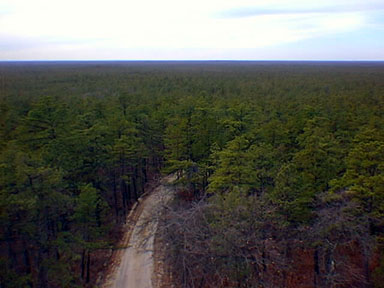
An exceptional hike in the Pine Barrens follows the Batona Trail between the Carranza Memorial to Apple Pie Hill (see Figure 135). The Carranza Memorial is a obelisk dedicated to Captain Emilio Carranza, a Mexican aviator who shortly after Charles Limburgh's transatlantic flight, flew from Mexico City to New York City. After a hero's celebration in the City, he attempted to fly home, but crashed and died near this site on July 13, 1928. From the memorial it is an easy and enjoyable walk eastward along sand roads and the Batona Trail past cedar swamps and through pine woods to two low hills (Figures 138). These two hills are remnants of an ancient pre-Pleistocene erosional surface comprised of the Pliocene Beacon Hill Gravel (see Tertiary Stratigraphy). The higher of the two is Apple Pie Hill, a local topographic high-point of about 120 feet in elevation; it has a fire tower built on its summit. One of the most amazing views on the East Coast is from the top of the stairs of the fire tower, allowing one to see over the tops of the trees (Figure 139). The view is of pine forests covering a level plain that stretches to the horizon in all directions. The only other features visible are a few cranberry bogs to the southeast, the tops of distant towers in Atlantic City to the east, and the tops of skyscrapers in Philadelphia to the west. (One can literally view the east-west extent of the State of New Jersey from here.) On a clear day it is possible to see several hilly escarpments far to the north. These are low hills on the coastal plain that are also capped with the Beacon Hill Gravel. It is unclear whether all of these deposits are the same age, or whether they were deposited by streams or by marine currents similar to modern gravel accumulations on the continental shelf. These gravel deposits have endured possibly millions of years of exposure to rainwater and organic acids from decaying plant material. All that remains on the hilltop is an assortment of heavily etched quartz pebbles.
 |
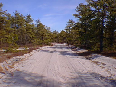
| Figure 138. Nearly pure white quartz sand lines a road through the pine barrens of Wharton State Forest. |
 |
| Figure 139. The nearly endless view of the pine barrens on the southern New Jersey coastal plain as seen from the fire tower on Apple Pie Hill in Wharton State Forest. |
| Return to Geology of the Coastal Plain Province. |