56. Shark River
Early Tertiary rock formations are exposed along the banks of the Shark River in southern Monmouth County, New Jersey (Figure 133).The name, "Shark River Formation," has been applied to units exposed along the stream near the Garden State Parkway. Unfortunately, the age and character of these units remains unclear. The section exposed along the stream banks west of the Garden State Parkway consist of a well-cemented glauconitic marl bearing an abundance of pelecypod molds (probably the Paleocene Hornerstown Formation). This unit is overlain by a clean quartz sand layer about a foot thick that is probably a source of shark and ray teeth that wash into the creek. This layer is overlain by another well-consolidated glauconitic marl unit that also bears pelecypod molds. This overlying unit is the Shark River Formation (probably Eocene). These units are truncated by the younger Miocene deposits exposed along the hilltop areas adjacent to the stream valley (Kirkwood or Cohansey Formations, undifferentiated).
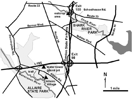 |
| Figure 133. Map showing the location of Shark River Park and Allaire State Park in Monmouth County, New Jersey. |
The sand unit at the base of the Shark River Formation is of particular interest, not just because it yields occasional fossil teeth and bone, but also because of the manner in which it controls landscape development along the creek. For a description of the Shark River Formation and its fossils see the Tertiary Stratigraphy page. Groundwater under pressure forces its way to the surface along the sandy layer, forming numerous springs along the hillside. Occasionally, a large artesian spring develops and the rushing water carves away the unconsolidated sand layer. Eventually the weight of the overburden causes a collapse in the form of a slump. Such slumps are common along the Shark River hillside near the Garden State Parkway.
Fossils are not abundant, but can be found in the gravel bars along the street, particularly upstream from the parkway bridges. Be extremely cautious of the steep cutbanks in that they may collapse at any time! A trail along the Shark River leads upstream from the playing fields parking area at Shark River County Park. It goes under the Garden State Parkway to undeveloped county land with trails used primarily for horseback riding. The footpath along the river quickly vanishes into tangled overgrowth. It is possible to sieve for fossils in the creek or a small side stream that enters from the north a couple of hundred yards west of the bridges (Figure 134). Pelecypods are abundant in the marl exposed along the creek bed. Avoid going here during insect and tick season, when it is hot, or if it has rained even slightly during the past of couple weeks. The spring fed stream tends to stay high longer that most streams, and can be is quite deep and swift. Stay out of areas posted with no trespassing signs.
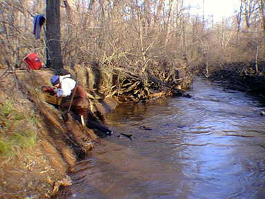 |
| Figure 134. Sieving for fossils from the stream gravel along the Shark River. |
Shark River County park is itself a scenic location for a picnic and a walk through the mixed deciduous and pine forest along the stream. To get there, take Exit 100 to Highway 33 east. A short distance east of the Garden State Parkway turn right (south) onto School House Road. The entrance to the park is just a half mile ahead on the right.
| Return to Geology of the Coastal Plain Province. |