Late Cretaceous Stratigraphic Units of the Coastal Plain
TINTON FORMATION - (Late Cretaceous [Late Maastrichtian]) - The Tinton is a massive "olive to evergreen" green glauconitic quartz sand which is locally clay-rich and silty. The unit displays an abundance of iron-staining and locally bears limonite and hematite crusts and concretions. Locally glauconite constitutes as much as 80% (or more) of the sand, making portions of the formation an economic greensand in the central Coastal Plain. Fossils, mostly poorly preserved molds and casts of pelecypods, Camptonectes, are common, whereas a richer marine fauna occurs further southward in central New Jersey. The unit displays heavy bioturbation. The formation is in the range of 20 to 25 feet thick.
REDBANK FORMATION - (Late Cretaceous [Maastrichtian]) - The Redbank Formation consists of gray to red sand deposited in nearshore environments. Groundwater flowing through the sand has leached away most fossil remains, and has altered the glauconite to limonite (hence the red color). A lower brownish- black micaceous sand unit is called the Sandy Hook Member displaying abundant concretions in bioturbated horizons; it is locally fossiliferous. The upper Shrewsbury Member consists of yellow to orange-gray sand. The unit is a approximately 120 feet thick near Sandy Hook along the valley of the Navesink and Shrewsbury Rivers, but grows progressively thinner until it eventually pinches out to the southwest.
NAVESINK FORMATION - (Late Cretaceous [Early Maastrichtian]) - The Navesink consists of peloidal glauconitic marl and sand that is locally thick bedded or crossbedded, and is locally clay-rich. Fossils are very abundant in some areas. Carbonaceous matter and phosphatic material is present, especially at the base. Mollusk fossils are abundant in the lower and middle portions of the unit. Common Navesink fossils include Belemnitella americana, Exogyra costata, Exogyra cancellata, Pyncnodonte sp., Ostrea falcata, Ostrea mesenterica, Choristothyris plicata, and many others (Figure 119). The fossils occur in concentrated horizons within the unit. The fauna suggest a marine shelf environment. The Navesink Formation ranges in thickness from 45 to 65 feet throughout the Atlantic Highlands region.
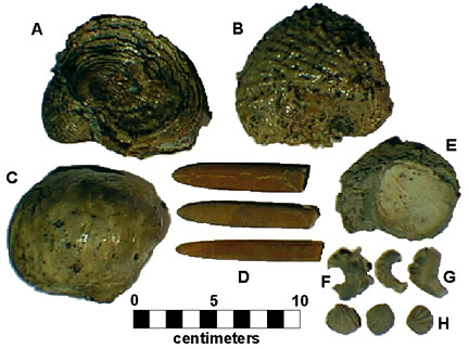 |
| Figure 119. Common fossils from the Late Cretaceous (Maastrichtian) Navesink Formation. Mollusks: A-B: Exogyra cancellata, C. Pyncnodonte mutabilis, D. Belemnitella americana, E. Spondylus gregalis, F. Ostrea mesenterica, G. Ostrea falcata; Brachiopod: H. Choristothyris pilcata. |
MT. LAUREL FORMATION - (Late Cretaceous [Latest Campanian]) - The Mt. Laurel is very similar in appearance and composition to the underlying Wenonah, with the exception that it contains abundant micaceous and glauconitic sand which is locally cross-bedded. The unit contains an abundance of phosphatic peloidal material and bioturbation features; siderite concretions commonly fill burrows. The unit is about 25 feet thick near Sandy Hook but pinches out landward over a distance of several miles beneath an unconformity under the overlying Navesink Formation. The boundary between the underlying Wenonah is undifferentiated in most areas east of the coast.
WENONAH FORMATION - (Late Cretaceous [Late Campanian]) - The Wenonah consists of micaceous quartz and silt rich in organic material (mostly silt-sized lignite fragments) and pyrite (in very fresh exposures). The unit ranges in thickness from 35 to 55 feet along Raritan Bay; inland, the upper part of the unit is exposed intermittently along creek banks. Phosphatic nodules, siderite concretions filling bioturbation structures, and thin sand beds are common near the top of the unit. Sharks teeth and fossil shell molds are common along with bone fragments and the teeth of fish, reptiles, and swimming dinosaurs in its upper units (Figure 120). Sedimentation patterns reflect storm-dominated deposition on a marine shelf environment. The thickness of the formation measures in the range of 70 to 100 feet.
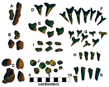 |
| Figure 120. Common fossils from the Late Cretaceous (Campanian) Wenonah Formation. Sharks teeth: A. Squalicorax, B-C various species (including lamniform sharks), D. goblin sharks (Scapanorhynchus) ; E. rays teeth. F-G. shark and unidentified vertebrate bone material; H. coral, I. casts of mollusks (gastropods and cardium-type clam). |
MARSHALLTOWN FORMATION - (Late Cretaceous [Middle Campanian]) - The Marshalltown consists of greenish-gray massive quartz-rich, glauconitic sand, silt and dark, micaceous clay. Pyrite and siderite concretions (some displaying evidence of boring and reworking) are abundant at the base of the unit. Other than traces of lignite and bioturbation, fossils are scarce in the unit. The thickness of the formation is between 15 and 20 feet.
ENGLISHTOWN FORMATION - (Late Cretaceous [Early Campanian]) - The Englishtown consists of clay, slit and sand which locally displays lamination, thin- to thick- bedding, and cross stratification. Fossils are generally scarce. Locally the unit contains lignite beach-type sand deposits. The uppermost beds display bioturbation with burrows locally filled with glauconitic quartz sand from the unconformable overlying Marshalltown Formation. The formation ranges from 20 to 150 feet in thickness.
WOODBURY SHALE - (Late Cretaceous [Early Campanian]) - Dark gray clay mud of the Woodbury Shale is exposed in excavations and along the shore of Raritan Bay near Cheesequake State Park, NJ. The gray carbonaceous shale contains pyrite nodules, bioturbation features, and some shell molds indicative of a restricted marine or lagoonal environment.
MERCHANTVILLE FORMATION - (Late Cretaceous [Late Santonian to Early Campanian]) - Conformably overlies the Magothy Formation and consists of mixed sand and clay units representing nearshore and shallow marine depositional environments. It is poorly exposed around the southern side of Raritan Bay. It interfingers with the overlying Woodbury Clay. The thickness of the unit measures between 20 and 100 feet.
MAGOTHY FORMATION - (Late Cretaceous [Coniacian and Santonian]) - Unconformably overlies the Raritan Formation. The Magothy occurs beneath Quaternary glacial cover throughout most of Long Island, the south shore of Staten Island, and it is fairly well exposed in small outcrops and excavations around Raritan Bay. In the Raritan Bay area, the Magothy Formation is subdivided into units: the Oldbridge Sand Member, the Amboy Stoneware Clay Member, and Cliffwood Beach Member (oldest to youngest, respectively). The Magothy represents nearshore and transitional alluvial depositional environments, similar to the Raritan Formation. The thickness ranges between 10 and 200 feet.
RARITAN FORMATION - (Late Cretaceous [Cenomanian]) - In the Raritan Bay region the Raritan Formation unconformably overlies Newark Basin and older rocks, representing the beginning of a series of major transgressions and regressions of the seas during Cretaceous time. The Raritan consists of clay, sand, lignite, and gravels representing progradational alluvial plain, coastal and nearshore marine environments. Very well exposed in unglaciated regions around the western end of Raritan Bay. Subdivided units include the Raritan Fire Clay, Farrington Sand Member, Woodbridge Clay Member, Sayreville Sand Member, and South Amboy Fire Clay Member (oldest to youngest, respectively). The Sayreville Sand Member is famous for its amber-bearing lignite lenses, insect remains, fossil wood, leaves, and pyrite nodules (Figure 121). The Sayreville fossil beds have yielded an astonishing amount of information about life in the Late Cretaceous. On Long Island, the Raritan is subdivided into the upper Raritan Clay Member and the lower Lloyds Sand Member - a major aquifer on the Island.
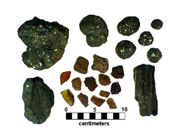 |
| Figure 121. Amber, fossil wood, with marcasite and pyrite from the Sayreville Clay Member of the Late Cretaceous Raritan Formation. |
POTOMAC FORMATION - (Early to Late Cretaceous) - A moderately well sorted and crossbedded, quartz sand,with quartz and quartzite pebble gravel lenses deposited in fluvial environments. The Potomac Formation is the basal sequence of the Cretaceous system in southern and central New Jersey (it is not recognized beneath the lower Raritan Formation in the bay area). The thickness is reported in the range of 250 to 800 feet.
| Return to Geology of the Coastal Plain Province. |