50. Cheesequake State Park
Cheesequake State Park got its unusual name from a word of forgotten meaning from the Leni-Lenape Indians who fished and hunted in the area long ago. The park was established in 1940 and has grown to encompass 1,274 acres. Although mostly a wildlife refuge, the park as also has picnic, swimming, and camping facilities. The park offers a variety of hiking trails through scenic woodlands along the shore of an expansive salt marsh along Cheesequake Creek (Figure 124). Despite being bisected by the Garden State Parkway, being neighbor to a massive landfill Superfund site, and its proximity to development, the park is one of the closest remaining natural areas to the City. The park had at one time been partially developed in the last century with numerous buildings that supported a pottery factory. The ruins of an old dock along Cheesequake Creek is a reminder of times when ships were the primary means of transport for commerce (and smuggling). Cheesequake is an extremely treasured preserve among the growing suburban clutter fringing the shores of Raritan Bay!
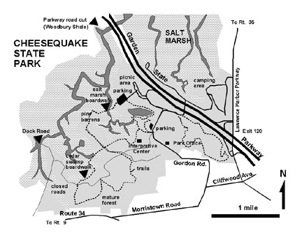 |
| Figure 124. Map of Cheesequake State Park. |
The park is open year-round during daylight hours. An admission fee is charged between Memorial Day and Labor Day. To get there, take the Garden State Parkway to Exit 120. Head south about a half mile on Laurence Harbor Parkway and turn right on to Morristown Avenue at a traffic light. Proceed about a half mile to Gordon Road and turn right. In a half mile you will reach the park entrance and park office; trailhead parking is on the left side of the road past the park entrance kiosk A short walk through the woods leads to the park's Interpretive Center.
The sedimentary rock formations underlying Cheesequake State Park include the Magothy Formation, the Merchantville Formation, the Woodbury Shale, and the the Englishtown Formation (oldest to youngest respectively). The Magothy is very well-exposed along creeks and lower hillsides throughout the park. The top of the Merchantville and the overlying dark-gray Woodbury Shale are well-exposed in an abandoned cut next to the Garden State Parkway on the north side of Cheesequake Creek. These formations and the overlying Englishtown Formation crop out along the hillsides on the south side of the park. From a geological perspective, the landscape around Cheesequake Creek is very young. Meltwater from the glaciers may have helped carve broad the valley of Cheesequake Creek when the advancing Pleistocene ice sheets temporarily blocked the flow of the Raritan River. The hillsides along the southern shore of the park preserve step-like terraces representing stages of time when broader stream valleys developed. The on-going processes of glacial rebound and stream down-carving left the older stream flood plains as terraces along the stream valley. In places the surface of the terraces still display scattered accumulations of the iron-stained quartz pebbles left by migrating streams. These deposits could be considered as outliers of the Pensauken or Bridgetown Formation. The wetlands have formed perhaps only in the last several thousand years as rising sea level progressively flooded the once deeper valleys of the Raritan and Cheesequake Creek. The progression of wetlands development proceeded gradually as sediment was trapped by an ever-increasing variety of salt marsh and wetland plant species. Sediments continued to back-fill the slack-waters and flats along the tidal creek.
A two to four mile walk along trails through the park is beautiful any time of the year, but it is best when the weather conditions are cool and therefore, less buggy. The park has well-maintained, closed gravel roads and trails with boardwalks. Trail maps and guides are available at the Park Office and at the Interpretive Center. One stretch of boardwalk passes through a very scenic grove of eastern white cedars; another crosses the tidal marsh. Trails wind through mature mixed deciduous forests and through patches of mountain laurel along the shores of the salt marsh (Figure 125) . The well-drained sandy acidic soil on the upland terraces are home to pitch pine, similar to the "pine barrens" which dominate the landscape farther south.
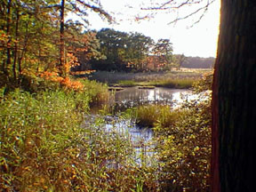 |
| Figure 125. Transitional coastal wetland environments at Cheesequake State Park. |
The occurrence of pitch pines at Cheesequake offer an interesting perspective on the origin of amber. A particularly strong nor'easter in the late winter of 1993 caused considerable wind and flooding damage in the region The combined effect of wind and flooding stripped away most of the loose plant debris near shore and across the salt marsh, and piled it in great heaps at the back of the slack-water areas of the marsh. Amongst the flotsam was an abundance of large balls of tree sap from the pitch pines. This environmental setting is perhaps a good analog for the formation of the amberiferous lignite deposits in the Raritan Formation around Kennedy Park.
| Return to Geology of the Coastal Plain Province. |