57. Allaire State Park
Allaire State Park is in the northern fringes of the pine barrens of New Jersey (see Figure 133 on the Shark River page). The park is named for the early 19th Century village of Allaire. This town developed around a furnace and forge that utilized two natural resources of the pine barrens: an abundance of oak and pine wood for charcoal, and the occurrence of bog iron deposits along the drainage of the Manasquan River. The town was named after an early industrialist, James P. Allaire, who supplied the first boilers for steam ships. He had purchased an older forge that had operated in the Tinton Falls area, then had orchestrated the development of a self-sustaining village around the ironworks that operated from 1822-1846. The industry declined as local charcoal supplies dwindled, and supplies of higher quality iron became available in the Highlands region. By the time of the Civil War, nearly all American iron manufacturing utilized Pennsylvania coal.
The Cohansey Sand (Miocene) and Beacon Hill Gravel (Pliocene) form the surficial deposits throughout the upland areas on the northern pine barrens and Atlantic Highlands (see Tertiary Stratigraphy). These deposits were left behind by the retreating shallow marine waters that flooded the coastal plain before the onset of glaciation. Because these deposits are dominantly sand, they tend to be well drained. As a result, the landscape is dominated by plant species, such as pitch pine, holly, and oaks, that can tolerate extended dry periods and thrive on acid soils. Decaying pine needles, oak leaves, other plant and animal material provide organic acids to help break down and dissolve iron-bearing minerals in the underlying sand and gravel deposits. The process of decay also removes available oxygen in the groundwater. Iron minerals are highly soluble in acidic water under reducing (low-eH) conditions. Iron is also derived from the decay of pyrite, glauconite, and other minerals in the underlying marine sedimentary rock formations. Bog iron deposits form throughout the pine barrens region along streams where reduced groundwater rich in dissolved iron rises to the surface. Near and at the surface this water encounters available oxygen, and with the aid of iron-fixing aerobic bacteria, iron minerals are precipitated. Limonite and goethite are the primary minerals formed in bog iron deposits. In some places the active formation of bog iron appears as a thick, orange gelatinous bacterial coating on everything in and along a stream. It is particularly obvious in areas of recent excavations which provide a passage for stagnant water to reach the surface. It is often thought of as pollution when, in fact, it is completely natural, and it helps in purifying the water! In stagnant areas, particularly in spring-fed swamps, the buildup of a thin iridescent layer on the water surface that looks remarkably like oil, but it is actually a thin surface crust of precipitating iron. The dissolved iron in groundwater contributes to the horrible bitter flavor of many ground water sources throughout the region. When this iron-rich water encounters the air it stains materials such as porcelain, and it accumulates as the brown scale buildup inside pipes. Iron and iron-forming bacteria in drinking water is not particularly dangerous in low concentrations, but it tastes foul and it can be gross to look at! Long term exposure to iron-rich water has been linked to a variety of diseases, but other more significant environmental factors may be involved.
Allaire State Park straddles Interstate 195 just west of the Garden State Parkway. The village of Allaire has been partially restored by Allaire Village, Inc., a private, non-profit organization, whereas the park is administered by the New Jersey Division of Parks and Forestry. The park incorporates over 3,000 acres and is host to picnic grounds with horseback and hiking trails that follow old gravel roads.The easiest way to get there is to take the Parkway to Exit 98, then travel west on Interstate 195 to Exit 31B. Turn north on Farmingdale Road and take an immediate right (east) on County Road 524 (Allaire Road). The park entrance is ahead about one mile on the right. During the summer and on weekends a fee is collected to enter the park and the village. Ask for a trail map at the Visitor Center. The hiking trails can also be reached via a playing field parking area on County Road 524 about a half mile east of the park entrance. The hiking trail starts across the road and leads northward through an oak and holly forest. It can be followed in a four mile loop back through the village. A good exposure of the Beacon Hill Gravel can be seen along this hike (Figure 136). It is located along this trail in a gravel pit next to a water tower on a low hilltop next to Interstate 195 (see Figure 133 on the Shark River page).
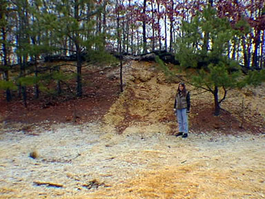 |
| Figure 136. A gravel pit in the Beacon Hill Gravel (Pliocene) near the water tower along the trails around Allaire State Park. |
| Return to Geology of the Coastal Plain Province. |