The Newark Basin
The geologic feature called the Newark Basin is foundation for the most heavily urbanized and industrialized portion of New Jersey (Figure 87). The basin extends south and westward from the lower Hudson River region, across northern and central New Jersey, and continues southward into Pennsylvania where it diminishes and then enlarges southward into the Gettysburg Basin. The half-graben structure of the basin is reflected by the gentle westward dip of the strata at about 15 (Figure 88). Possibly as much as 11,000 feet of sedimentary rock and volcanic material of Mesozoic age exists beneath the surface on the western side of the basin. A great border fault system defines the western side of the basin. One of these, the Ramapo Fault, extends southward from the Hudson Highlands region east of the Hudson River (in the vicinity of the Indian Point Nuclear Power Plant). In New Jersey, Interstate 287 roughly follows the trace of the fault southward to near its intersection with Interstate 78 where other faults define the western border of the basin. This fault is responsible for the escarpment of the Ramapo Mountains of the Highlands that rise on the western side of the fault.
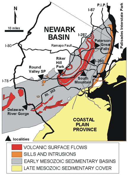 |
| Figure 87. Map with field localities in the Newark Basin, New York, New Jersey, and Pennsylvania (after Drake et al, 1996 and Lyttle & Epstein 1987). |
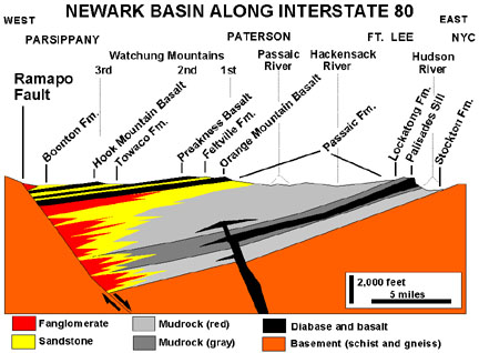 |
| Figure 88. East-to-west cross-section of the Newark Basin along I-80. |
Figure 88 illustrates the general structure and stratigraphy of the Newark Basin along Interstate 80. The three lower formations, the Stockton, Lockatong, and Passaic Formations are Late Triassic red beds. Volcanic intrusions of Jurassic age, including the Palisades Sill, has intruded within these formations. The 1st, 2nd, and 3rd Watchung Mountains, east to west respectively, have been renamed Orange Mountain, Preakness Mountain, and Hook Mountain, respectively, and provide the names for the Jurassic age surface flows responsible for their origin. (The word, Watchung, comes from the Lenape Indians meaning high hills.) The sedimentary formations between and above these flows, the Feltville, Towaco, and Boonton Formations, represent basinal sediments deposited in the Early Jurassic. The gentle westward dip of the strata probably continued to develop after the youngest formations were deposited.
The traprocks within the Newark Basin display subtle differences in both composition and physical appearances from one location to the next. The composition of the rock varies from ultramafic (rich in olivine) to dioritic, depending on the amount of dilution of basaltic magma with quart-rich material derived from the continental crustal rocks it invades and partially melts as it migrated toward the surface. Where the magma cooled more slowly beneath the surface within volcanic stock and sills, the more moderately crystalline textured rock is called diabase. The dominant igneous rock-type is the fine-grained extrusive form of basalt that formed as volcanic material extruded on the surface and cooled as flows. However, the physical character of the basalt varies considerably form one area to the next, depending on how the rock cooled.
Where massive amounts of material erupted on a flat surface, the lava flows generated were locally as much as 200 feet thick. As the lava cooled, it shrank and cracked. In places where homogeneous lava cooled at an uniform rate vertical polygonal columns formed. If the lava flowed down a sloping surface, the flows tend to be thinner, and they cooled more rapidly and unevenly. On modern volcanoes, blocky-textured flows (called "aa" after Hawaiian usage) have an uneven texture which forms as material that has cooled on the surface is mixed downward into the migrating flow. This causes inconsistent cooling patterns within the flow, resulting in an irregular fracture pattern within the resulting lava rock. Flows where the lava is much hotter and more fluid tend to spread out and cool with a smooth, billowy or ropy surface (called "pahoehoe"). This hotter lava tends to spread out as fingers of lava that cool as irregular pods called "pillows." Pillows that form underwater tend to be more rounded, more fractured, and have thicker glass-textured rinds than pillows that form on land. All types of flows can be recognized in the traprocks of the Newark Basin.
The character of the geologic structure of the Newark Basin is quite apparent when driving westbound on any of the interstate highways that cross the basin. Beautiful exposures of fanglomerates, brownstone, and traprock can be seen in road cuts along the highways, but unfortunately, they are not safe or legal to stop and examine. The sites described below include a mix of scenic natural areas on public lands and popular geologic field trip destination sites in the Newark Basin region.
| Return to Mesozoic Basins Province. |