39. The Palisades
The Palisades are the impressive cliffs that line the western margin of the Hudson River from Jersey City to the south, to northward of the Tappan Zee Bridge (Figure 89). The Palisades (meaning "fence of stakes") were named by the explorers with Verrazano in 1524, who thought they resembled the log forts built by the local Indians. The cliffs and forested talus slopes rise to more than 600 feet above the river. In the mid 19th Century, the Palisades were being quarried for building materials, ship ballast, and for concrete aggregate. Because of the close proximity to New York City, the forested hillsides were being decimated for firewood. With the efforts of the New Jersey Federation of Women's Clubs the Palisades Interstate Park Commission was established in 1900, and was granted the authority to purchase and manage the land. Through generous gifts of philanthropists including Rockefellers, Harrimans, Perkinses, Morgans, and others, the Commission bought its first 14 miles of property. Many of the parks trails and facilities were built by the Civilian Conservation Corp (CCC) and Works Progress Administration (WPA) during the 1930s. The completion of the George Washington Bridge in 1931 resulted in a real estate boom in New Jersey which threatened the park. A plan devised by the Commission settled on the construction of the Palisades Parkway. This plan paved the way for the purchase of land and the condemnation of numerous properties, including several mansions of the rich and famous built along the ridge. Today, the western view from the hilltops in northern Manhattan give the false perspective that the land west of the Hudson is still wilderness!
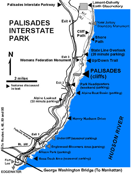 |
| Figure 89. Map of the Palisades Interstate Park of New Jersey and New York (after PIP park brochure). |
The Palisades were designated a "National Natural Landmark" being "the best example of a thick diabase sill in the United States." The sill extends southward beyond the cliffs in Jersey City beneath the Inner Harbor, and reappear on Staten Island (see Figure 24 on the Staten Island page). The Palisades are the eroded cross-section of a large intrusive diabase sill that intruded between layers of sandstone and shale of the Late Triassic Stockton and Lockatong Formations. (In the Staten Island area, the strata equivalent to the Lockatong Formation is called the Brunswick Formation.) The sill approaches 1,000 feet thick and was probably fed from an unknown stock buried beneath the basin to the west. Radiometric age determinations of the diabase suggest that the sill formed in multiple stages between about 192 to 186 million years ago (late Early Jurassic). Exposures of the basal chill zone, a zone of contact metamorphism of the underlying sedimentary layers, occur scattered amongst the massive talus slopes at the base of the cliff. The upper side of the sill also has a chill zone with the upper part of the sill displaying many xenoliths (pieces of the overlying host rock in which the sill intruded). Within the lower portion of the sill there is a zone of rock enriched in olivine, a high temperature ultramafic mineral that formed first and settled to the bottom of the intrusion before the rest of the magma cooled. This zone is about 10 to 15 feet thick, and crops out along and above the road in the Ross Dock area near the south entrance to the park (see Figure 89).
The escarpment of the Palisades reveals the strike of the eastern margin of the Newark Basin. The path of the Hudson River follows the trace of the underlying unconformity at the base of the Stockton Formation (see Figure 88 on the Newark Basin page). This unconformity represents the gentle ancient landscape surface that existed in the region before rifting occurred. As continental glaciers scoured the lower Hudson River Valley, the softer sedimentary cover above this unconformity was preferentially stripped away. In addition, during low-standing sea level, the Hudson River also preferentially followed this boundary.
There are many places to access the Palisades. An outcrop of diabase at the top of the cliffs is one of the first thing you see when you emerge onto the ramp from the Lincoln Tunnel on the New Jersey end. The Palisades also anchor the western end of both the George Washington and Tappan Zee Bridges. The ten mile stretch between the George Washington Bridge to the the NJ-NY state line offers many places to examine the spectacular scenery within the Palisades Interstate Park. A trail system that follows the crest of the Palisades begins at the western end of the George Washington Bridge. It is possible to walk across the bridge from the 175th Street/George Washington Bridge Station on the A train in Manhattan. The better alternative would be to drive across the bridge and go north along the Palisades Interstate Parkway and pull off at the numerous overlooks along the way (see Figure 89). It is possible to find extended parking at Alpine (Exit 2), where Henry Hudson Drive descends from the ridge top and follows the shoreline southward beneath the cliffs into Edgewater, New Jersey. The Lamont-Doherty Earth Observatory, a part of Columbia University, is located just north of the New Jersey/New York border at Exit 4 on the Palisades Interstate Parkway. This satellite campus offers open houses annually, an attraction that no one interested in geology would want to miss!
A scenic seven mile loop trail provides combines hiking along both the shoreline and along the cliff top. There are two places to begin the hike. It is possible to park is at the top of the cliff at the Palisades Interstate Park Commission's Headquarters Building. (Unfortunately, it is only lawful to park in the lot on the weekends.) It is also possible to park at the Alpine Boat Basin picnic area at the base of the cliffs off Henry Hudson Drive. Perhaps the best hiking route is to walk north for three miles along the Shore Path, climb the steep trail to the Cliff Path to the Women's Federation Monument, and return via the cliff top trail. Along the Shore Path there are several small spring-fed waterfalls and some of the most scenic views of both the Palisades and the Hudson. The highest cliffs are located below the Women's Federation Monument (Figure 90). In that area the hillside below the cliff is littered with great talus blocks. Exposures of the lower chill zone in the shale of the Stockton Formation can be seen along the path that ascends to the monument. The Cliff Path offers access to numerous scenic overlooks at the cliff's edge. In many places along the barren cliff tops it is possible to see grooves and striations from moving glacial ice. Ice moving towards the south-south east plucked away the great diabase columns, forming the shear cliff of the Palisades. Large crevasses along the ridge top provide evidence of the tremendous forces that can be generated by freezing and expansion of ice in cracks! Fragments of Palisades Diabase can be found practically everywhere in glacial and shore gravel deposits in Manhattan, Brooklyn, Queens, and Staten Island.
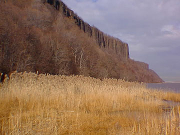 |
| Figure 90. View of the Palisades escarpment from along the Hudson River near Alpine, New Jersey. |
| Return to Mesozoic Basins Province. |