43. Watchung Reservation
The Watchung Reservation is a nature preserve encompasses 2000 acres straddling portions of the 1st and 2nd Watchung Mountains to the south and west of the Milburn near Scotch Plains, New Jersey (Figure 99). There are a variety of locations in the area worth examining, including exposures of Early Jurassic red beds and basalt flows. To get there, go west on Interstate 78 (look at, but don't stop at outcrops along the highway) to Exit 43 (New Brunswick/Berkeley Heights). Head south on New Providence Road (you will have to turn around). About one mile south of I-78 turn left onto NJ 527. In less than a mile bear right onto Sky Top Drive. Sky Top Drive, winds along the ridge of 1st Watchung Mountain within the Watchung Reservation. In two miles, Sky Top becomes Coles Avenue. About a half mile further, park at the Trailside Nature and Science Center.
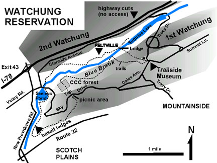 |
| Figure 99. Map of the Watchung Reservation near Scotch Plains, New Jersey. |
The Trailside Museum has trail maps of the preserve. (It also offers a variety of nature exhibits and a planetarium, plus offers a variety of programs for families and groups.) The Blue Trail leaves the museum parking area leads westward downhill about a quarter mile to the valley of Blue Brook, a stream that carved the valley between the 1st and 2nd Watchung Mountains. The valley formed along the strike of the less weathering resistant red beds of the Early Jurassic Feltville Formation. Red sandstone and shale beds of this formation crop out along stream level and along an old, abandoned rail line that follows the north side of the stream. On the south side of the stream are exposures of a highly fractured flow of the base of the Orange Mountain Basalt (Figure 100). The partially restored village of Feltville, a village that centered around a 19th century paper mill and printing operation, is located on the hillside north of the creek, a quarter mile south of where the trail from the museum crosses a bridge over Blue Brook. The best exposures of the red beds are along the abandoned rail line and along cut banks in the stream and its tributaries.
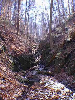 |
| Figure 100. A V-shaped, post-glacial ravine carved into the Orange Mountain Basalt in the Watchung Reservation near the historic village of Feltville, New Jersey. |
A long hike through the Reserve is a beautiful way to spend a day. A large red and white pine forest planted by the Civilian Conservation Corp in the 1930s is located just north of a picnic area on Sky Top Drive. Along the western end of the 1st Watchung ridge the hiking trail follows along a series of ledges formed by the lower flows of the Orange Mountain Basalt. These outcrops occur in an old abandoned quarry and along the stream flowing along New Providence Road. It is possible to park at one of the pull offs south of Seeleys Pond along New Providence Road, and walk along the creek trail to examine the base of the ledges of basalt.
| Return to Mesozoic Basins Province. |