45. Delaware River Valley Scenic Route
A field trip along the Delaware River provides opportunity to examine exceptional exposures of the Late Triassic formations of the Newark Basin (Figure 103). The Delaware River has carved a gorge with a narrow flood plain that cuts in a transect almost perpendicular to the strike of the Newark Basin. Almost 2,000 meters (+6,000 feet) of sedimentary rock crop out in continuous succession along the Delaware River Gorge. The examination of roadside exposures might be combined with a picnic or a hike along the tow path in Delaware and Raritan Canal State Park, a park that stretches for 21 miles along the valley between Trenton and Milford, New Jersey. The best route is to begin in the south and drive northward, examining road cuts occasionally along the way. As you travel in this direction you gradually ascend through the stratigraphic section. This is because the rocks are gently dipping to the northwest. This trip is best either in the mid spring before the leaves have completely blocked the scenery, or in the late fall as the leaves are coming down.
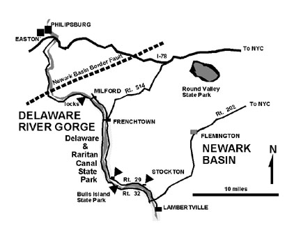 |
| Figure 103. Map of the scenic route through the Delaware River Gorge along the New Jersey/Pennsylvania border where a thick sequence of Newark Basin strata is exposed. |
Take Route 202 west from Flemington, New Jersey toward Lambertville. Exit onto Route 29 North just before crossing the Delaware River. Although there are exceptional road cut exposures along Route 202, the highway is posted, and the traffic can be quite heavy. Drive north along Route 29 to Stockton. Exposure of fanglomerate of the Stockton Formation, consisting of coarse red sandstone and sandy shale occur in weathered road cuts and throughout active and abandoned quarries in the Stockton area. (Do not enter quarries without permission.) The sandstone exposed here is technically called an arkose. Arkose consists of coarse-sand to gravel-sized grains; has a pink or red iron-rich matrix, is rich in feldspar grains (at least 25%), and is derived from the rapid disintegration of granite or granitic rocks (often resembling them). It is interesting to note that Stockton is near the geographic center of the Newark Basin, however the sandy sediment is quite coarse grained.The alluvial fans that formed these deposits must have extended as much as 30 kilometers away from the border fault region to the west.
North of Stockton, the character of the sedimentary rock changes to consist of dark gray color, alternating between fine-grained sandstone and shale. These rocks occur in cliffy road side exposures north of Stockton in the vicinity of Byram, New Jersey. These rocks are part of the Late Triassic Lockatong Formation, and represent sediments deposited in a great lake that flooded the central portion of the Newark Basin during Late Triassic time. The alternation between shale and sandstone units suggests that the water depth of this lake fluctuated up and down cyclically.
Exposures of a diabase sill crop out along Route 29 at Byron, New Jersey. The diabase is highly fractured, with joints filled with minerals including amphibole, calcite, epidote, and prehnite. The diabase intruded into the Lockatong Formation probably during the Early Jurassic when all the other volcanism occurred in the region.
A couple miles north of Byram the sediment character begins to change gradually. Thin units of red sandstone begin to appear between layers of darker, brownish gray sandstone and shale. As one proceeds northward, these red units eventually dominate the section. The change from dark-gray to red suggests the transition from lacustrine (lake) deposits to shoreline mud flats and fluvial (stream) deposits. These deposits are recognizable by sedimentary structure including mud cracks and beds consisting of desiccated mud chips that were reworked into stream channel lag deposits. Where these red beds dominate the stratigraphic section the rock is assigned to the Passaic Formation. These two formations are transitional from one to the other with no well-defined contact. The Lockatong (gray) and the Passaic (red) represent sedimentary facies that interfinger one another. This alternation of sedimentary facies developed as the shoreline of the ancient lake advanced during wet periods, and withdrew during dry periods. These types of cycles are well known in the fossil record around the world. Perhaps the best analogy is the great cycles in the expansion and retreat of lakes in the African Rift Valley associated with the cycles of glaciation.
There are many other options that can be considered for a trip to this region. The fastest return route to the city would be to take Route 513 north from Frenchtown, New Jersey to get on Interstate 78. A brief visit to Round Valley Reservoir provides an opportunity to examine the border fault and the intrusive rocks (diabase) of Cushetunk Mountain. Another option is to continue driving northward along the Delaware River. North of Frenchtown, the better road to drive is on the Pennsylvania side (Route 32) where the canal follows the western side of the river (Figure 104).
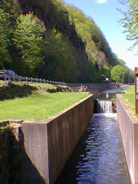 |
| Figure 104. Locks along the Delaware-Raritan Canal along Pa Route 32 north of Frenchburg, New Jersey. The steep cliffs are of Late Triassic Lockatong Formation. |
Bulls Island State Park (south of Byram) is located six miles north of the intersection of routes 202 and 29. Bulls Island is an artificial island created by the construction of the canal where a river dam was built to divert water into the canal. A good place to stretch the muscles is to park next to restored canal lock near the park entrance and take a walk westward across the foot bridge into Pennsylvania. This is also a good location to start an out-and-back hike along the canal tow path.
| Return to Mesozoic Basins Province. |