2. Cloisters Museum and Fort Tryon Park
Fort Tryon was built as a northern outwork of Fort Washington. The fort was overrun by Hessian mercenaries during the Revolutionary War. The Cloisters, part of the Metropolitan Museum of Art, was constructed on the northern end of the hilltop. The museum includes imported and reassembled French and Spanish medieval and Renaissance churches, monistic art, and architectural structures.
Parking is limited around The Cloisters, especially on weekends. It is perhaps easier to park at the Fort and walk the short trail over to the museum. Around the base of the Cloisters and along the trail between Fort Tryon and the museum are small exposures of mica schist with bands of gneiss. The surface of these rocks have a gray, weathered appearance, however, in freshly broken exposures the highly foliated rock displays the sparkle of biotite mica which predominates over quartz, lesser amounts of plagioclase, and traces of garnet. Outcrops on the west side of the Cloisters display glacial striations and grooves (Figure 18). The overlooks around both the fort and the museum offer spectacular views that are best when the leaves are down. To the south and east one can see the Harlem River, much of the Bronx, with the Harbor Hill Moraine on the south shore of Long Island Sound forming the dark hill along the southern horizon. To the west is a spectacular view of the forests and cliffs of Palisades on the New Jersey side of the Hudson River. The slope of the westward facing hill generally follows the trend of nonconformity at the base of the Newark Series, the great sequence on Early Mesozoic sedimentary and volcanic rock formations that dip gently westward into the Newark Basin in New Jersey. The path of the Hudson River follows the strike of the Newark Basin rocks exposed along the eastern edge of the basin (see Figures 16 and 17).
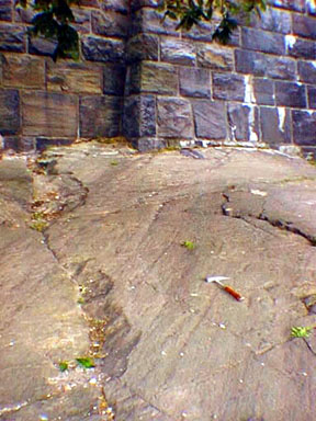 |
| Figure 18. Glacial groves and striations in the Cambrian Manhattan Formation along the foundation of the Cloisters Museum. Rock hammer handle is 1 foot for scale (not for collecting!). |
It is interesting to note that the highest point in Manhattan is in Bennett Park, along the west side of Fort Washington Avenue between 183rd and 185th Streets, at an elevation of 265 feet. In contrast, not far from this location are two of the deepest public locations in Manhattan; the IRT-Broadway Seventh Avenue station at 191st Street and Saint Nicholas Avenue (180 feet below street level), and the IND Eighth Avenue station at 190th Street and Fort Washington Avenue (165 feet below the street). These stations were built this deep so that rail lines would conform with those of the rest of the city, minimizing track grades.
| Return to the Highlands Province Main Page. |