Our Transient Coastal Environment
The modern shoreline of the New York Bight is one of the most rapidly changing landscapes on Earth. This claim is substantiated by examining the amount of change through time caused by the forces of both nature and man. Interestingly, these forces are largely opposing each other. Humans are constantly modifying the coastal environment, in many cases without a clear understanding of the long-range consequences. Nature involves an amalgam of forces, usually delicate and gradual, but occasionally irresistible. No where is this more apparent than in our coastal setting. With the ongoing explosion in our population, the development of our shoreline has proceeded in a practically uncontrolled manner. As a result, very little of the natural coastal ecosystem that existed four centuries ago remains unaltered. Although large sections of the shore have been set aside as recreational and nature preserves, areas that have not have been heavily developed. The chief geologic processes affecting the shore include human-induced coastal modifications, and the consequences of episodic giant storms. One major storm can move as much sand and sediment as the cumulative effect of many years of "normal" coastal wave energy and minor storms (see Morton, 1988).
Through the 1970s and 1980s nearly half of all construction in North America occurred in low coastal areas within harm's way of major storm and flood damage. As a result, storms along our coasts are now reported in a manner of costs of millions to billions of dollars in real estate damage. The fact remains that we have been incredibly fortunate to have never had a truly catastrophic storm in the New York Bight in historic times, however, we have had several close calls. For example, in 1992, Andrew (a Class 4 hurricane) caused billions in damage to the Biscayne Bay and Everglades regions of South Florida; had the track of the hurricane led directly toward downtown Miami, the cost of the storm could have been between one and two orders of magnitude higher. Likewise, in 1989 Hurricane Hugo (a Class 3 storm) hit a relatively low populated portion of the South Carolina coast. Camille of 1969 (a Class 5 storm) was perhaps the most destructive storm in historic times to affect the mainland United States. Near the eye of the storm, the surge rose 24 feet above normal sea level. Beach-front erosion can be devastating. When Hurricane Eloise hit the Florida Panhandle in 1985, it carried away an average of 45 cubic yards of sand for each yard of beachfront along a nine mile section of coast (see Williams, 1992).
In the recent past, the New York Bight has experienced several major hurricanes and winter equivalents (called "nor'easters"). However, the potentially most destructive storms hit the region before the modern era of urban development. Most hurricanes that reach the New York Bight occur late in the summer to early fall, and are typically undergoing diminishing stages of intensity (Figure 166). The region's most destructive storms included Gloria in 1985, Donna in 1960, Carol and Edna in 1954, an unnamed storm in 1944 (when America's attention was more focused on WWII), and a storm of perhaps class 3 magnitude that hit largely undeveloped eastern Long Island in 1938 (see Coch, 1994). This 1938 storm killed hundreds of people and caused catastrophic destruction in the region, but if such a storm were to hit today the consequences would be of perhaps unimaginable devastation.
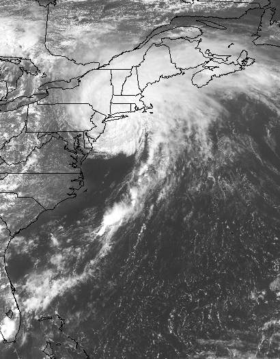 |
| Figure 166. Hurricane Bertha (1996) was a Class 1 hurricane by the time it made landfall on Long Island, and only caused minor damage. Both hurricanes and nor'easters are cyclonic storms with counter-clockwise rotation (NOAA weather satellite image). |
Nor'easters occur more frequently in the metropolitan area and some may
reach hurricane proportions. What they lack in intensity, they make up
for in duration, lasting sometimes for several days. A long-lasting storm
gradually carves away at the beach, with perhaps the greatest damage occurring
in its later phases. Nor'easters generally occur between the late fall
and early spring. The nomenclature refers to the onshore flow of moist
air from around the northeast side of a nearshore or onshore low barometric
pressure center. In addition to causing coastal erosion, if temperature
conditions are cold enough, nor'easters can produce large quantities of
snow. For instance, the "Blizzard of the Century" (January 7-8,
1996) dropped as much as 30 inches of snow on parts of New York City,
with even greater accumulations in parts of the Appalachian Mountains.
Discussion in this section include:
Beaches and Barrier Islands
Geologic Setting of the Modern Shore
The Story of Atlantic Sea Coal Deposits
Selected shore field trip destinations include:
66. Island Beach State Park
67. Sandy Hook (Gateway National Recreation
Area)
68. South Beach, Staten Island
69. Breezy Point/Fort Tilden (Gateway National
Recreation Area)
70. Jamaica Bay (Gateway National Recreation
Area)
71. Plumb Beach (Gateway National Recreation
Area)
72. Coney Island
73. Jones Beach State Park
74. Robert Moses State Park/Fire Island National
Seashore
75. Westhampton Beach
However, be sure to check these selected shore destination sites as well (discussed in previous sections):
50. Cheesequake State Park
63. South Point, Staten Island
64. Caumsett State Park
65. Montauk Point
| Continue to Humans, Agents of Geologic Change. |