63. South Point Conference House, Tottenville, Staten Island
South Point is the southernmost point in New York State. It is located at the intersection of the Arthur Kill where it joins Raritan Bay. Along the wave scoured shore at South Point are outcrops of Wisconsin-age glacial till which demonstrate that glaciers reached the southernmost extent of New York State (Harbor Hill moraine). The outcrop of unstratified till consists of a mix of reworked material from points north. Large blocks of Palisades diabase, Precambrian and Paleozoic metamorphic rocks, and Newark Basin sedimentary rocks are mixed with clay, silt, sand, and gravel more typical of glacial deposits in New Jersey. (Similar deposits crop out around the intersection of Highway 440, the Garden State Parkway, and Route 9). These outcrops demonstrate that the Raritan River Valley marks the southernmost advance of the glaciers. Rising sea level flooded the valley forming Raritan Bay. The scour of waves and tides have exposed glacial till in sea cliffs along Arthur Kill (Figure 158).
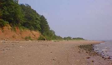 |
| Figure 158. Glacial moraine exposed in sea cliffs at South Point on Staten Islands. This is the southernmost outcrop in the state of New York. |
Bring a picnic with you to this beach. On a summer weekend it is possible to take a short tour of the Conference House, the restored home of British naval captain Christopher Billopp, built around 1680. The home was was used for a meeting between Benjamin Franklin, John Adams, Edward Rutledge, and British officials in a failed attempt to negotiate the end of aggression during the Revolutionary War. The house sits on a low hill overlooking the mouth of Arthur Kill and Raritan Bay. The downtown waterfront of Perth Amboy, NJ is situated on the south side of Arthur Kill from this locality.
The Conference House is located at 7445 Hylan Boulevard (the southern terminus of the road). Take either Exit 3 (Hylan Blvd) south after crossing the Verrazano Narrows Bridge, or stay on the Staten Island Expressway to the West Shore Expressway, and exiting at the last exit before the Outerbridge Crossing (Arthur Kill Rd.); drive south and turn right on Bentley St.; then turn right onto Hylan Blvd. Park on the street or in the parking area at the Conference House. During low tide a large amount of glacial material is exposed along the shore. It is possible to walk south along the shore for about a half mile around the point to examine the moraine outcrops.
| Return to Glaciers of the Quaternary page. |