Geologic History of Raritan Bay
South Point on Staten Island is a good location to develop an appreciation of the evolution of the landscape around Raritan Bay since late Pleistocene time (Figure 159). Arthur Kill is an abandoned river channel carved by an ancestral phase of the Hudson River resulting from the blockage of the main channel at the Verrazano Narrows by moraine or ice. The size of the channel is large, suggesting that it was, for a time, the primary drainage from the region. However, it was not a primary drainage for long because the river did not have enough time to carve a broad flood plain. This channel probably developed during Stage 3 (a mid-Wisconsin interglacial stage). By comparison, the valley of the Raritan River to the south is much broader. This is an indication that the Raritan was perhaps the major drainage channel along the ice front throughout the Wisconsin glaciation (Stages 1,2,3, and 4). Prior to that time the region drained southward across the saddle between the Atlantic Highlands and the Newark Basin into the Delaware River Valley. This saddle area is a very broad flood plain that preserves river terrace gravels (Pensauken Formation) from the Sangemon Interglacial State (Stage 5), as well as older Pleistocene fluvial deposits (The Bridgetown Formation). During the lowstand in sea level caused by the Wisconsin glacier, the Raritan River carved back into its headlands and captured the major drainages from the Newark Basin.
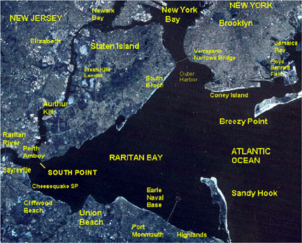 |
| Figure 159. Landsat image of the Raritan Bay area. |
As the Wisconsin glaciers melted, the Flandrian Transgression eventually flooded the deeper valleys of the Hudson, Raritan, and Arthur Kill. During warming at the end of the Pleistocene and Early Holocene the area encompassing Raritan Bay changed from tundra to a landscape dominated by spruce and pine forests. These forests gradually gave way to the modern deciduous forest in the region by mid-Holocene time. Lagoons and bays in the area around Sandy Hook hosted oysters, hard and soft shell clams, lobsters, blue crabs, and a variety of other invertebrates common in bays in the region today (see Figures 148 to153). South of western Long Island, tidal flats and wetlands occupied the margins of a tidal estuary (now submerged by marine waters). Inner Raritan Bay began to fill about 2,500 years ago with large oyster beds forming along the estuarine tributaries. Sea level continued to rise about one foot per century. This rise in sea level has resulted in the landward migration of the shoreline (aided by storm-induced coastal erosion) as much as two miles in some portions of the coast since colonial times.
Sediment from the Raritan River, however, is filling in the valley faster than sea level can flood the shorelines. This is probably a reflection of the impact of human activity (deforestation, and agricultural and urban development) more than the result of any natural cause. Raritan mud is accumulating in portions of the bay at a rate of about 0.75 inches per year (see Mackenzie, Jr., 1992; Bokuneicicz, 1988). Portions of the valley that were once exposed several thousands of years ago are now buried about 150 feet deep in mud. The influx of mud aids in the development of the tidal wetlands and marshes along the south and western ends of Raritan Bay (including the wetlands preserved in Cheesequake State Park). Sand dominantly covers the sea bottom in the lower portion of the bay whereas mud dominates the bottom throughout the middle portion of the bay.
Archeological evidence suggests that humans were already in the region at the close of the Pleistocene (probably actively contributing to the mass extinction of a variety of North American wildlife species). The early "Big Game Hunters" vanished, but the coastal regions were resettled by peoples accustomed to village-style living ("tidewater communities") that subsisted on hunting and gathering marine shellfish, and eventually, on agriculture. In pre-Columbian times "woodlands cultures" probably centered in the Ohio Valley became the dominant cultural influence in the region. Large shell middens were found around Raritan Bay and on Staten Island, a testament of the utilization of the bay for food by Algonquin Indian tribes (Lenapes) who occupied the area when early Colonialists arrived. Unfortunately, early settlers used these shell piles for road construction and field fertilizer. Tottenville was once well known for its roads paved with oyster shells!
In the 1600s oysters grew in two large beds in the western end of the bay. The largest measured oyster bed was about a mile across and was located just beyond the mouth of the Raritan River; it was contiguous with oyster beds that lined the lower river estuary for as much as five miles upstream. A smaller oyster colony, called the Chingarora bed by the Lenape Indians, was located in what became Keyport Harbor. Oysters also grew abundantly along the tributary rivers of the Raritan Bay, including the East, Hudson, Navesink, and Shrewsbury Rivers, as well as along most of the Arthur Kill and in southern portions of Newark Bay. The oyster beds were located where salinity ranged from about 5-15 ppt at the end of tidal ebb flow.
Shellfish ecology is a useful measure of physical characteristics of the bay. Oysters grow about a half inch per year in salinity ranging from 5-10 ppt, and about an inch per year in salinity ranging from 12-20 ppt. Higher salt concentrations allows other encrusting marine organisms (algae, barnacles, bryozoans, and slipper shells) to take space away from oysters. Hard clams (Quahogs) are distributed over most of the bay and inhabit both sand and mud. They live below the intertidal zone in areas with salinity above about 15 ppt. Soft clams are abundant in the intertidal zone near the mouth of the bay, especially in the Atlantic Highlands area where salinity is higher. Raritan Bay is the southernmost location where American Lobsters can live near shore. South of the bay they can live in the cooler waters out on the continental shelf. Raritan Bay is also the northernmost area where blue crabs occur in large numbers and are abundant almost every winter. In the summer they migrate to the tributaries of the bay (Hudson and Raritan Rivers, etc.).
A large counter-clockwise gyre affects the mixing of waters in the bay. Residence time for water is about 60 tidal cycles. The salinity ranges from a low of about 12 ppt at the bottom near the mouth of the Raritan River, to about 32 ppt off Sandy Hook. Water temperatures range from about 33 F in late January to 78 F f in late August. The mean tidal range is about 5.5 feet with coastal storm surges ranging to as much as 12 feet or higher. Winter winds are dominantly from the northwest, whereas summer winds are from the south and southwest. Hurricanes are most likely to affect the region in August through early October. Nor'easters (winter storms) are most likely to affect the region during late November to mid-April. Wide tidal flats are exposed during the lowest spring tides. These tidal flats were up to a mile wide during low tides during the 1800s and early 1900s; coastal landfills and "shore management practices" have developed much of these shallow areas along the south and western sides of the bay.
The development and utilization of the marine resources of Raritan Bay can be compared to the traditional views of American West. On the more romantic side, the lucrative fishing industry during the nineteenth and early twentieth centuries helped to support a stable population around the bay, and aided, in part, to feed the flood of immigration. Stable communities continued to grow and change with new industries supporting a larger population base. For instance, Perth Amboy NJ was the capitol of the East Jersey colony and was a provincial capitol until near the end of the 1700s. Advances in methods of fishing and shellfish collecting resulted in over-extraction of these resources from the bay. The peak of the fishing industry occurred in the late 1880s to 1910s. Fishing and farming slowly gave way to industries including ship building, ceramics, chemicals and paint manufacturing, electrolytic copper refining, and petroleum refining. In the Sayreville NJ area large pits were dug to extract the clays for ceramics and bricks, and huge chemical dumps, fly ash piles, and landfills were created to accommodate the waste from the growing industrial empire. The building of shore management structures (dikes, groins, seawalls), the spraying of DDT (and other pesticides) to control the mosquito problem, the carving of ditches to drain wetlands, the filling of shore lowlands, the channelization of creeks, highway and sewer construction, neighborhood development, and a myriad of point and non-point sources of household, automobile, industrial chemicals, and ocean dumping all contributed to growing toxicity of the bay. For most of the twentieth century, the shores of Arthur Kill has been home to the largest petroleum importing, refining, and storage facilities on Earth; as a consequence the estuary has been host to major and minor oil spills. In addition, Arthur Kill drains the area encompassing the second largest landfill on Earth (Fresh Kills). This landfill, and others along the Raritan River, provide an ample supply of leachate to the waterways. Chemical wastes cause stress and disruption of the life cycles of plankton, shellfish and other invertebrates, and the fish, birds, and other wildlife they support. The result has been ecological disaster. The bay approached sterile conditions at the peak of pollution and algal bloom-induced anoxia. Environmental actions from the 1970s to present have helped slowly bring back sea life, but current conditions pale to the wealth of marine resources of the past; certain species of fish and birds continue to decline, and the introduction of tenacious exotic species from around the world contribute to their decline. As a sign of optimism though, oysters are beginning to naturally reappear in the Hudson River after having vanished completely about the time of WWII.
Changing environments are inevitable, and natural catastrophes of greater scale than those of the modern human invasion have happened in the past. As little as 18,000 years ago, the world around Raritan Bay was a cold, barren tundra with sediment-choked streams. In as little as 10,000 years, with humans present from the onslaught, the landscape evolved into a diverse deciduous forested region on land, and equally catastrophic or opportunistic changes probably affected the marine habitats. The greatest modern extinction occurred around the transition between the Pleistocene and the Holocene (during the Younger Dryas). Whether humans or natural causes were to blame for this catastrophe will be the subject of debate for a long time. Today, with the help of humans, there are more species living in the region (wild, exotic, and domestic) than perhaps during any period in the past. However, the traditional environmental concerns for habitat loss and extinction remain grave issues.
| Return to Glaciers of the Quaternary page. |