Quaternary Geology of the New York City Region
In a sense, the Quaternary is a story of "big chills" and "small fevers" during the latest period of Earth history. The influences of continental glaciation are discernible throughout the New York Bight region. In many ways, the most recent stage of continental glaciation added the "finishing touches" to the modern landscape (Figure 141). The most obvious glacial features are the large erratics (glacier transported boulders) and scattered deposits of glacial till (a mix of fine silt, sand, gravel, and large boulders). The flowing ice of the southward advancing ice sheet sculpted the landscape by not only eroding and transporting vast quantities of rock and sediment, but also by blocking and altering the course of rivers, filling valleys with sediment, and depositing large quantities of till in the terminal moraines along its leading edge. These hills are apparent throughout Long Island and across the central lowlands of New Jersey. In the upland areas that were once covered by the glaciers, barren exposures of bedrock frequently preserve a smooth glacial polish, grooves, and striations carved by rocks embedded in the base of the glacier.
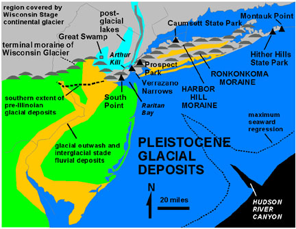 |
| Figure 141. Pleistocene glacial deposits and features in the New York City region. |
The literature about the Ice Ages is quite voluminous, considering the multi disciplinary interest in the subjects ranging from biological evolution, climatic change, and landscape development to name a few. Even so, many questions relating to this geologically recent period of time remain unresolved. This is particularly evident in definitions and resolution of time chronology relating to "ice ages." The Cenozoic Era is divided into the Tertiary and Quaternary Periods: the latter represents only the last two to three million years. The Quaternary is subdivided into the Pleistocene Epoch and Holocene Epoch, with the latter representing roughly only the past 10,000 years. The exact beginning and end of the Pleistocene Epoch are still under debate. The term, "Pleistocene," is not based on glacial deposits, rather on stratigraphic sections of sediments in an unglaciated region of southern Italy. The base of the Pleistocene in this "type" area has been dated at 1.65 million years. However, evidence now suggests that earliest phases of glaciation associated with the Ice Ages began in Pliocene time approximately around 2.4 million years ago.
The cause of the great Ice Ages of the Quaternary is the focus of much research, especially in with regard to the modern concerns of "global warming" as a possible result of the accumulation of greenhouse gases in the atmosphere (especially CO2 and CH4). Certain aspects of the climatic change appear to be related to variations in insolation (INcoming SOLar radiATION). In 1864, a self-educated Scottsman, James Croll, proposed the hypothesis that variations in the Earth's orbital elements were enough to cause the Ice Ages. However, it wasn't until the 20th Century that Milutin Milankovitch went through the laborious endeavor of calculating the overlapping cycles of changing patterns in the Earth's revolution, rotation, and tilt, and how they might affect the amount of insolation received at different locations on Earth (Figure 142). His calculations showed a pattern that matches the occurrence of periods of glaciation. However, nature is far too complex for a simple conclusion. Modern determinations have to consider the function of global ecosystems, such as the ocean/atmosphere circulation and heat transfer, the role of ice sheets, cloud patterns, and sea ice. Perhaps least understood are the cycles associated with greenhouse gases. The availability of atmospheric methane and carbon dioxide are linked with vegetation cycles and weathering processes, and to gases trapped by permafrost and by clathrates (methane ice) in sea sediments. In addition, the "trigger" of the Ice Ages is still unclear. For nearly 200 million years prior to the Pleistocene, global glaciation cycles probably did not occur on such a grand scale. Possible triggers for glaciation include the disruption of the atmospheric flow caused by the uplift of the Himalayan Mountains, and the changes in the global ocean circulation brought on by the closing of the Isthmus of Panama. Both of these slowly-developing geologic events took place as the Ice Ages began very late in the Tertiary. In addition, there have been numerous massive volcanic episodes during the course of the Quaternary. Some of these probably released a volume of greenhouse gases equivalent to the combined effect of all modern civilization since the Industrial Revolution. There are probably other factors that have yet to be discovered.
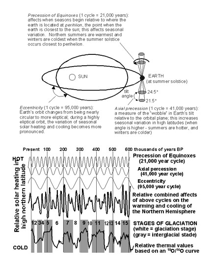 |
| Figure 142. Comparison of Milankovitch Cycles to stages of Pleistocene glaciation (modified after Imbrie & Imbrie, 1979). |
In portions of the world the Ice Ages are still in progress. This is evident by the existence of the ice sheets that still cover Antarctica and in Greenland. However, the extent of ice cover on the continents was much greater during major phases of continental glaciation through the Pleistocene. The main areas of accumulation were Scandinavia, northern Siberia, and perhaps most extensively, North America (Figure 143). During the Pleistocene Epoch there were many stages of continental glaciation. Each "stage" represents a major period of glacier formation and advance, and each lasted in the range of 20,000 to 100,000 years. During these periods the overall climate of the Earth was both cooler and wetter. Under these conditions, large alpine (mountain valley) glacier systems and large continental ice sheets developed in high latitude regions. During the greatest stages, as much as a third of the land surface was under ice. These episodes of glaciation were interrupted by periods of time ranging from several thousand to many tens of thousands of years when the Earth became hotter and dryer. During these periods called "interglacial stages" (or "stades") the large glaciers retreated or completely vanished. On land, evidence of older glacial episodes were pretty much obliterated by more recent advances of the continental glaciers.
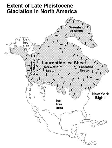 |
| Figure 143. Map of North America showing the extent of Late Pleistocene glaciation (modified after Pielou, 1991). |
Stages of glaciation have been linked to shifts in the isotopic ration of oxygen (18O/16O ) in seawater. The shift of oxygen isotopic values has been recognized in shell material and fossil plankton (particularly foraminifera) derived from deep sea cores of sediment from around the world. A cyclic pattern of enrichment and depletion of the lighter 16O in sea water is inferred to be related to the buildup and melting of continental glaciers (see Figure 142). The natural refining process of evaporation and precipitation concentrates the lighter oxygen isotope in precipitation (rain, snow, etc.). When large volumes of ice build up on the continents, the heavier variety of oxygen (18O) becomes slightly more concentrated in seawater. Living marine organisms incorporate an imprint of oxygen isotopic values normalized with sea water into their shells. After the organism dies, the calcium carbonate in its shell preserves the oxygen isotope ratio of seawater during the time that it lived. As younger shells and sediments accumulate on the sea bed, a record of progressive shifts in 18O/16O values are preserved. Cores collected from the sea bed are examined, and the data are compared to other methods of relative dating (such as radiocarbon and other absolute dating methods, and magnetostratigraphy). Even though exact time resolution and correlation of these global cooling cycles around the world are still poorly resolved, all things considered, great progress has been made. As many as sixteen global cooling cycles have been resolved dating back into the Early Pleistocene. Modern researchers have simplified the terminology used to organized the chronology of the Ice Ages. The timing of glaciation stages and interglacial stages are numbered in reverse order, with glacial advances assigned even numbers, and interglacial stages referred to by odd numbers. We are currently in Stage 1, an interglacial stage that encompasses all of the Holocene and the period of melting at the end of the Pleistocene. Stage 2 is the most recent advance of the continental glacier. Stage 3 was the previous interglacial stage before present; Stage 4 the prior glacial advance to Stage 3, etc. Some of these pulses of glaciation affected the New York Bight area more than others.
The sheer volume of literature published prior to the more modern methods of determining absolute dates on events continues to force the use of established terminology for glacial and interglacial stages. The subdivisions of Quaternary history that are resolved in the New York Bight region are shown in Table III.
| Table III. Late Quaternary History of the New York Bight. | ||
| NEW TERMINOLOGY | OLDER TERMINOLOGY | COMMENTS |
| Stage 1 | The Holocene Epoch- our current post-glacial age - plus the period of warmth near the end of the Pleistocene | Stage 1 began when global warming began abruptly about 14,000 BP (years before present) |
| Stage 2 | The most recent advance of the Wisconsin Glacier which culminated about 20,000 BP. | In the New York Bight region, this stage corresponds to the formation of the Harbor Hill Moraine. |
| Stage 3 | A period of mixed warming and cooling roughly between 45,000 and 70,000 BP, high-standing seas occurred about 60,000 BP | During this period the Wisconsin glacier "retreated" (melted back) an unknown distance northward |
| Stage 4 | The initial phase of the Wisconsin glacier culminated between 90,000 to 70,000 BP | This glacial advance resulted in the formation of the Ronkonkoma Moraine along the south shore of Long Island |
| Stage 5 | The Sangemon Interglacial Stage, a prolonged period of warmth between 105,000 to 130,000 BP (beginning on the Late Pleistocene) | Fluvial deposits (Pensauken Fm.?) are preserved in stream terraces along the along the Delaware River Valley, and probably formed during the Sangemon Interglacial Stage |
| Stage 6 | The Illinoian glaciation ended abruptly about 130,000 BP. Glaciation during the phase began sometime between 185,000 to 250,000 BP | Glacial till and outwash gravels associated with the Illinoisan glaciation are recognized just south of the terminal moraine in central New Jersey |
| Stages 7-32? | Multiple stages of glacial advances and melting back | These stages are not yet resolved in the New York Bight region |
The majority of the older literature relies on a chronological order of glaciation cycles based on interpretations of terminal moraine deposits in midwestern United States. For a time, the paradigm existed that there were only four major glacial advances: the Wisconsin, Illinoisan, Kansan, and Nebraskan Stages, youngest to oldest respectively. However, additional research has determined that the history of these deposits are complex, and each of these stages may actually represent more than one glacial advance. The marine record is much easier to interpret, but unfortunately the correlation of these terrestrial glacial stages with numbered marine stages is poorly resolved. Some resolution is possible based on widespread ash deposits from volcanic eruptions in the Rocky Mountains region, and on the known occurrence of the end of a magnetic polar reversal period at about 0.73 million years ago. This reversal is currently used to define a boundary between the Early and Late Pleistocene.
| Continue to the Transient Atlantic Shoreline page. |