64. Caumsett State Park
Caumsett State Park is located on Lloyd Neck, a small peninsula that projects northward from the south shore into Long Island Sound. In 1921, Marshall Field III, a wealthy newspaper publisher, purchased 1,750 acres of farmlands, woodlands, meadows, salt marsh, and rocky shoreline. He built a sprawling English-style estate that he called, Caumsett, after the original Matinecock Indian name, which means "place by a sharp rock." The park was acquired by the state of New York in 1961. The original mansion is now the Queens College Center for Environmental Teaching and Research. The massive polo pony barn is now part of the Caumsett Equestrian Center.
Caumsett offers exceptional exposures of Pleistocene glacial deposits and features related to shoreline development along Long Island Sound. A trip to the shore involves about a five mile circuit hike along park roads, trails, and the gravel covered shoreline. The scenery is spectacular, and a day trip to the park is highly recommended!
To get there, go west on the Long Island Expressway to Exit 49 or go west on the Northern State Parkway to Exit 40. Turn north onto Route 110. Follow 110 into Huntington. Here the roads become somewhat confusing, and, of course, there are no signs, but be persistent! In Huntington, turn left onto Route 25A. Head west several blocks and turn right on West Neck Road. Follow this winding road north past Lloyd Harbor to the park. There is a $4 entrance fee between May and October. The park is open from 8AM to dusk.
From the parking area walk along the park road to the Marshall Field House (Figure 160). The house is situated on top of a mound of the Harbor Hill moraine. From the rear patio is a stunning view of Long Island Sound with the headlands of southern Connecticut in the distance. Just to the west of the house, a park road descends down the moraine to the shore next to a freshwater pond. From this point, walk westward along the coast for just under a mile, taking time to examine the structures exposed in the shore bluffs and the various kinds of rock types represented by the pebbles, cobbles, and boulders that litter the shore. Thanks to glacial transport there is an astounding variety!
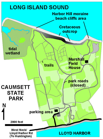 |
| Figure 160. Map of Caumsett State Park on the north shore of Long Island, New York (after park brochure). |
Near the base of the cliffs are exposures of the Late Cretaceous Magothy Formation (Figure 161). This sedimentary unit is exposed in numerous places along the shoreline of Long Island Sound. The exposures in Caumsett consists of a light gray to brownish sandy clay with lenses of lignite. Unlike the Magothy exposures in New Jersey, there is no amber in these exposures. However, occasional partial leaf impressions and wood are exposed as the sticky clay dries and cracks along bedding surfaces.
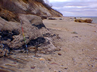 |
| Figure 161. Lignite in the Late Cretaceous Magothy Formation exposed at the base of the sea cliffs in Caumsett State Park. Note the large glacial erratics on the gravel beach. |
The bluffs of glacial till consist of both unstratified till and stratified outwash gravel deposits, particularly along their western exposures (Figure 162). This stratified gravel displays partial sorting characteristics of running water. Where the unstratified section is typical moraine, the stratified gravels probably represent the deposits of a stream channel flowing beneath the ice front deposited during a stage of melting.
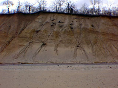 |
| Figure 162. Stratified (outwash) and unstratified (till) deposits exposed in the sea cliffs along Long Island Sound in Caumsett State Park. |
The tidal range along the north shore is approximately seven feet, and as a result shore currents can be particularly strong, especially during nor'easters. Waves during high tide are gradually carving back at the poorly consolidated glacial deposits exposed in the cliffs. For this reason it is quite dangerous to attempt to walk along the top of the sea bluffs. Wave and tidal energy is reworking the glacial sediments, and building a sand pit that extends westward for over a half mile beyond the base of the sea cliffs. The gravel beach ridge forms a protective cove around a salt marsh drained by tidal creeks.
While walking along the shore, note the different kinds of rock transported to this location by the continental glacier. Most of the rock consists of foliated or banded gneiss, schist, and granite derived from the Western Connecticut Uplands. There are also fragments of basalt and red sandstone of Connecticut River Basin origin. An intriguing addition is the occurrence of well-cemented ironstone conglomerate. No such deposits are known from the Connecticut region. These deposits probably represent the remnants of coastal plain-type ironstone-cemented gravels that were eroded away by the advancing glaciers.
Walk back to the parking via the Fishing Road intersecting the beach at the western edge of the sea cliffs . Be sure to check for ticks which can be present and dangerous here any time of year. Other interesting attractions in the area include Sagamore Hill (President Theodore Roosevelt's family home) and the Planting Fields Arboretum (see Figure 32 on the Mianus River Gorge page).
| Return to Glaciers of the Quaternary page. |