74. Robert Moses State Park/Fire Island National Seashore
Fire Island is a narrow barrier island protecting the south central coast of Long Island from Atlantic storms (Figure 192). The barrier island stretches for 32 miles, bounded by Moriches Inlet to the east, and Fire Island Inlet to the west. Nowhere is the island wider than a mile. At some locations along its eastern and central portions the width can be as little as several hundred yards.The island forms the southern border of Great South Bay, one of the most productive shellfish and seafood estuaries along the Atlantic seaboard. Although most of the island is undeveloped, there are seventeen small beach communities that are used primarily for summer recreation. In 1908, Governor Charles Evans Hughes signed a bill authorizing Fire Island as a state park, making it the first park on Long Island.
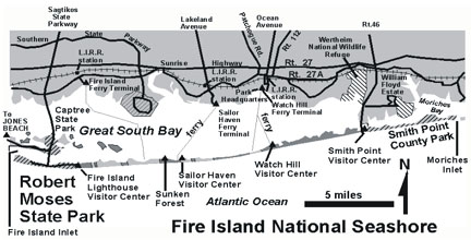 |
| Figure 192. Map of Fire Island National Seashore with Robert Moses State Park along the south shore of Long Island. |
In the region's early history, the frequency of ship wrecks and piracy along the coast of Fire Island prompted the United States government to construct a lighthouse at the western tip of the island. A lighthouse was erected in 1825 and then rebuilt in 1858. The Fire Island Lighthouse stands as an interesting marker and is perhaps the most popular attraction of the barrier island. The accretion of sand by longshore drift has since extended the western end of Fire Island a distance of more than five miles (At a rate of about 50 meters per year) (Figure 193). When Fire Island was established as a state park in 1908 the western tip was located near where the Robert Moses Water Tower now stands (at the intersection of the Robert Moses Causeway with the park road). The construction of a jetty (circa 1950) to protect Fire Island Inlet to Great South Bay temporarily stalled the progress of accretion, but now it is still proceeding. The sand is being provided partly at the expense of erosion of the eastern end of the islands supplemented by a supply from sand bars and ancient barrier island deposits now submerged offshore.
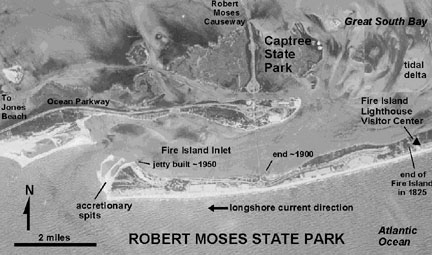 |
| Figure 193. Aerial photograph map of Robert Moses State Park. Note the location of the end of Fire Island in 1825 when the lighthouse was built. |
In 1938 the park facilities and settlements on Fire Island were devastated by a hurricane. As a result, what was to become Robert Moses State Park received a massive overhaul. New land formed by accretion on the western end of the island was ceded from the Federal to the State government. Sand was pumped onshore to build up part of the island to a height of 18 feet above mean sea level - the height engineers estimated as necessary to protect park facilities from future storm damage. Even though this was a massive undertaking, the park reopened with new a new layout and bathhouse facilities within a year. The Robert Moses Causeway connecting the barrier to Captree State Park and the mainland was completed in 1964. At its opening the west end of the park was renamed Robert Moses State Park. (Interestingly, Robert Moses' original intention was to build a parkway the entire length of the Fire Island! His plan met stiff environmental resistance.) Also in 1964 the rest of the island became incorporated into Fire Island National Seashore under the stewardship of the National Park Service. In 1980 Congress designated 1,400 acres including a seven mile stretch of the island as a national wilderness area. The Otis Pike Wilderness Area is located between the Watch Hill Visitor Center to the west and the Smith Point Visitor Center to the east (see Figure 192).
The Fire Island Lighthouse and Visitor Center is a unique attraction. A boardwalk from the parking area at the east end of Robert Moses State Park leads to the lighthouse via a back beach maritime shrub forest. A circuit hike can include a walk back along the waterfront with an opportunity to examine the dunes and the beach. In the winter, the beach is heavily eroded back to the dunes (Figure 194). The nearly constant winter winds blow and sort the sand; broad patches of red garnetiferous sand build up on the surface of the back beach area. In the spring and summer the sand migrates back onto the beach and the garnet sands gradually vanish from view (Figure 195).
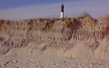 |
| Figure 194. Layered bedding exposed by storm erosion of the shore dunes. The top of the Fire Island Lighthouse is in the distance. |
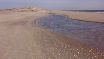 |
| Figure 195. A runnel is formed on the beach as a bar migrates on shore in the spring (after much beach erosion during the previous winter) at Robert Moses State Park. |
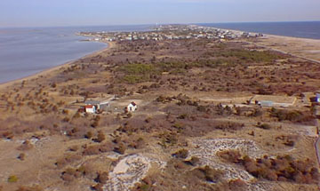
Guided tours of the lighthouse (involving the climb of the 192 steps
to the lighthouse observation area) provide a spectacular view of Robert
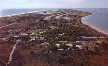
Moses State Park to the west (Figure 196), Fire Island to the east (Figure
197), the ocean and beach to the south, and vast expanse of Great South
Bay to the north. Scheduled lighthouse tours and programs offer opportunities
to learn about many aspects of the often deadly events on the shore and
the sometimes bizarre history of life on Fire Island.
During the summer, ferries leaving the Sailor's Haven terminal in Sayville,
New York provide access to the Sailors Haven Visitor Center on the island.
A popular attraction nearby is the Sunken Forest: this is a shady old
growth forest with hollies up to 200 years old, sassafras, and other hardwoods.
However, the trees rarely grow above about 30 feet in height. Their tops
are constantly pruned back by the salty wind blowing over the tops of
the beach dunes. The dunes and the forest owe their existence to one another.
The forest plants bind the sand creating a stationary barricade for the
dunes to build up, and the dunes provide shelter from the salt wind. Without
the dunes and the forests the island would not survive!
 |
| Figure 196. Westward view from the Fire Island Lighthouse observation deck of the "new land" that has formed since the lighthouse was built in 1825. This new land is now Robert Moses State Park. |
 |
| Figure 197. Eastward view from the Fire Island Lighthouse observation deck of the increasingly narrow Fire Island. |
The Watch Hill Visitor Center is accessible from a ferry terminal near the park headquarters in Patchogue, New York, with boat service limited to the summer season (Late May to September). A trip from Watch Hill offers access to self-guided nature walks through salt marshes, a tidal estuary, the beach, and back dune areas. The Smith Point Visitor Center offers the same kind of exhibits and trails, and is accessible by car, open year round.
Over the centuries storms have chewed away at the beach, and in some cases, carved new inlets. However, Fire Island survives and rebuilds itself. As sea level has steadily risen, the barrier island and the bay have slowly moved landward. Eventually strong storms will come along and breach the barrier, hastening the migration of the barrier island to a site closer to shore. This inevitable change has been stalled by the construction of jetties and dikes, but eventually the residents along the coast of the south shore of Long Island will have to face and accept the formation of new inlets and the closing of old ones. These changes would cause uncertain problems for property owners and businesses, but in the long run these alterations would probably benefit the habitats for wildlife of the bay by adding sand to the substrate and creating a shorter path with better tidal circulation of marine waters in and out of the bay. To neglect the inevitability of such changes is short-sighted and ultimately disastrous, as exemplified by the Westhampton Beach disaster.
| Return to Our Transient Coastal Environment. |