65. Montauk Point
A trip to Montauk, the Point, is more of a pilgrimage for individuals interested in coastal dynamics and Pleistocene history (Figure 163). Montauk is a small peninsula that juts into the Atlantic Ocean on the end of Long Island. Montauk Point State Park is located on the end of the Peninsula. Hither Hills State Park is located just east of a narrow saddle that connects the peninsula to Long Island. The parks are separated by the town of Montauk. Farther east on the peninsula is Nepeague State Park. Hither Hills and Napeague Parks are separated by a narrow neck of sand and by Nepeague Harbor.
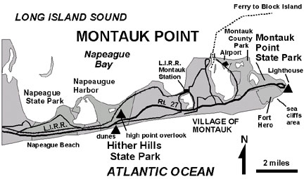 |
| Figure 163. Map of Montauk Point, eastern Long Island, showing the location of Hither Hills and Montauk State Parks. |
Montauk Point State Park consists of 724 acres of scrub oak "tundra" and features the historic Montauk Lighthouse (Figure 164). The park adjoins public land of Fort Hero (an deactivated military installation, now a state park) and by Montauk County Park. Along the shore near the Montauk Lighthouse, wave energy is constantly battering away at sea cliffs exposing the glacial till of the Ronkonkoma moraine (early Wisconsin, Stage 4). During the final stages of Wisconsin glaciation, this moraine was continuous northward across the exposed shelf to Block Island, Martha's Vineyard, Nantucket Island, and beyond. As sea level rose during the late stages of the Flandrian Transgression, the Ronkonkoma moraine began to be assaulted by coastal erosion. Today, only the islands remain visible; the remnants of these moraines are submerged and are continuing to endure submarine erosion. About 5,000 years ago, the Hither Hills and Montauk Point were separate islands. Through time, marine erosion along the Atlantic shore carved back the headlands of the glacial moraine. Longshore currents gradually built up spits that eventually connected the islands at Montauk Point and at Hither Hills to Long Island. Today, the sand and gravel eroded from the headlands at Montauk and from the massive sand reservoir offshore (originally derived from the moraine and outwash) are the primary sources for sand on the beaches along southern Long Island.
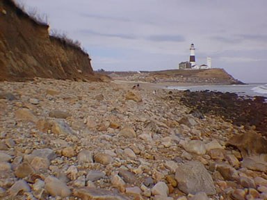 |
| Figure 164. The boulder-covered beach and moraine cliffs exposed along the Atlantic Ocean. Montauk Lighthouse is in the distance. |
Montauk is continuing to erode. Montauk Lighthouse (America's first lighthouse) was built by Washington's authority in 1796. It was originally about 300 feet inland. Two hundred years later, only about 50 feet of hilltop space remains. The Corps of Engineers began building a massive rip-rap rock wall around the base of the lighthouse in the 1970s.
East along the Atlantic shore, sea cliffs of the Ronkonkoma moraine rise about 70 feet above a narrow shingle (cobblestone) beach both north and west of the lighthouse. The moraine exposed in the cliffs of Fort Hero contains angular pebbles, cobbles, to large boulders (erratics) cemented by a tightly compacted brown mud matrix rich in clay and silt. By comparison to the Harbor Hill moraine along the north shore, the older Ronkonkoma moraine is more consolidated and degraded by chemical weathering. Iron is gradually leaching from the till and precipitating as limonite along crevices and fractures in the till.
A walk along the beach provides an opportunity to examine a wide assortment of rock types in the beautifully wave polished boulders and cobbles on the beach. Rocks consist of granite, gneiss, schist, and quartzite derived from the New England Highlands region. Occasionally, pieces of coral wash up on the beach. These fragments frequently display many years of growth. Stony coral develops from larva carried north by the Gulf Stream. In the New York Bight region it attaches itself to rocks on the sea bed, but typically survive only one summer season. The larger pieces of coral reflect a time in the recent past when warmer conditions prevailed, allowing the coral to continue growing from one year to the next.
An orientation overlook and historical display is located at the Montauk Point Visitors Center. On a clear day it is possible to see the south shore of Connecticut, and Block Island far off to the northeast. In the winter, however, the point is frequently enshrouded in mists. Frequent winter storms batter the point with winds measured up to 100 mph. Waves and opposing tides between the Atlantic and the Sound create extremely hazardous conditions for boats and small ships in the straits between Montauk Point and Block Island. In many ways, a trip to the Point during a storm is a good lesson about nature's fury! Scheduled tours of the Montauk Lighthouse are offered by the Montauk Historical Society.
To get to Montauk, take Route 27 (Sunrise Highway) all the way west to where it dead ends in the parking area at the Point. From Manhattan, it takes about 2.5 hours (without traffic). An alternative is to take the Long Island Railroad to Montauk Station (about $25 round trip). From the train station it is possible to walk into town and rent bicycles. It is also possible to take the ferry to Block Island. Flights into Montauk airport are another interesting possibility. Because of Montauk's popularity, it is extremely important to make sure you have accommodations planned far in advance!
Hither Hills State Park is comprised of 1,755 acres of forested rolling terrain and beaches on both the Atlantic, and along two bays on the Sound. The Old Montauk Road (Route 27) straddles a high hill in the park. At the crest, a roadside overlook provides a spectacular view of the region (Figure 165). The park is host to a broad beach and field of coastal sand dunes along the Atlantic Ocean. The wind-blown sand derived from the beach is gradually invading the scrub oak forests established on the Ronkonkoma moraine. It is interesting to compare the beach at Montauk to the beach at Hither Hills. Within a distance of 10 miles nearly all the gravel and cobbles have either been separated out or abraded down to sand.
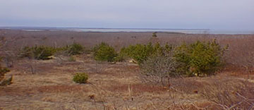 |
| Figure 165. View from the Highway 27 hilltop overlook in Hither Hills State Park, looking northward towards the shallow bays along Long Island Sound. |
| Return to Glaciers of the Quaternary page. |