Beaches and Barrier Islands
An examination of a modern beach or barrier island is an essential endeavor for students of many disciplines. The study of modern shore processes and ecology can provide insight into unraveling conditions and processes in the geologic past. Figure 170 shows a generalized cross-section of a typical modern barrier island in the New York Bight region. Modern barriers are constantly eroding away or accumulating new material depending on the ever changing conditions of the sea. Two important factors facing the modern geologic setting are that sea level is steadily rising, and that humans are playing an ever increasing role in the modification of the environment. A barrier island is an ecosystem which consists of a range of faunal habitats. Within these habitats are a range of smaller environmental settings. Organisms that live on or around barrier islands typically occupy an environment with a range of controlling ecological factors including exposure to water, salinity, oxygen, and daily and seasonal variability in light, temperature, food availability, predation, turbidity (or sedimentation rate), wave energy, tidal range, and other factors. Humans provide additional environmental stresses by adding pollution, predation, new species (exotics), and any number of environmental modifications. Some species, such as blue crabs or soft shell clams, can be found in practically any marine or brackish water environment, but their numbers vary considerably with time of year and environmental conditions. Other species, such as star fish, sand dollars, jingle shells, and mollusks are uniquely marine; oysters, on the other hand, thrive in brackish waters. Common shells from area beaches are illustrated in Figure 171. Plants on barrier islands also display an range of tolerance factors that can be easily examined.
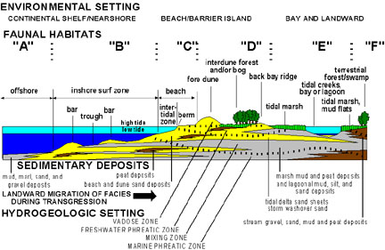 |
| Figure 170. Environmental setting, faunal habitats, sedimentary deposits, and hydrologic setting of a barrier island. |
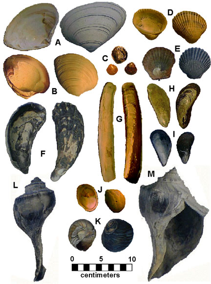 |
| Figure 171. Common shells from the beaches of the New York Bight: A. Surf Clam; B. Quahog; C. Jingle Shell; D. Ponderous Ark; E. Atlantic Bay Scallop; F: Eastern Oyster;. G: Atlantic Jackknife Clam; H. Atlantic Ribbed Mussel; I. Common Blue Mussel; J. Slipper Shell; K. Common Moon Snail; L. Channeled Whelk; M. Knobbed Whelk |
The transition from open marine shelf to barrier island begins in water depths offshore where waves start to impact the sea bed. With the increase in wave energy, the substrate becomes increasingly rich in sand and gravel. In this offshore zone sand bars host a variety of burrowing invertebrates and their predators. The location of these bars are most obvious during low tide on days of calm weather. Typically between one hundred and two hundred meters offshore is where the first set of breakers form across the tops of these bars. These bars tend to build up in the winter at the expense of beach deposits. They gradually migrate shoreward during the spring and summer. Bars sometimes become exposed as new or temporary beaches with inshore runnels that becomes flooded during high tide. These runnels eventually fill in as the sand continues to migrate shoreward.
The beach (or littoral zone) forms at the intersection between land and sea and consists of three general environments. The inshore surf zone is a subtidal tract is constantly bombarded by incoming surf. The intertidal zone is the portion of the beach that is intermittently exposed between tidal cycles. The beach rises gradually or steeply to the berm or (beach crest) that generally marks the boundary of the highest tides. Typically the mark of the previous high tidal cycle is marked by a wrackline, a discontinuous trail of shell debris, pebbles, and other flotsam left behind at the point where the wave swash halts. The flat back beach area between the berm and the beach dunes is a supratidal environment that is only wet occasionally by storm waves during high tide. This occasional wetting is enough to prevent plants from becoming established. The dunes behind the back beach are built up of wind-blown sand. Shore grasses and plants adapted to this harsh environment help to buffer the wind, thus causing the sand to be deposited. Excavations into healthy shore dunes show horizontal stratification. This is a reflection of the involvement of plants in attenuating the wind and the slow, steady growth of the shore dunes. The horizontal banding is a reflection of the steady compaction of sand over time. This compaction makes the natural dunes more resistant to erosion. Whereas the larger barren hills of sand are visually more impressive, they are more transitory and are not as enduringly stable as the plant anchored dunes.
Shoreward of the dunes is the heavily vegetated portion of the barrier island. This is a maritime community consisting of rare, fragile, and unique plants and animals adapted to the harsh conditions along the shore. These shrub forests are established on older, stabilized dunes and beach deposits. Because water drains immediately downward into the sand, the surface habitat ranges from hot, desert-like conditions in the summer, to cold tundra-like conditions in the winter. The strong winds along the shore, particularly in the winter months, give the shrubs near the dunes a dwarfed, weather-beaten (krummholz) appearance. Plants such as juniper (red cedar), holly, bay berry, poison ivy, Virginia creeper, prickly pear cactus, sumac, golden heather, and various grasses are adapted to these extreme, semi-arid conditions on the beach and to typically older secondary dunes farther inshore.
The bay or lagoonal side of the beach is host to a variety of different habitats from the ocean side. First, the bay typically contains brackish water (reduced salinity results from the influx of freshwater from streams or groundwater from the mainland). The bay- or lagoon-facing shore of a barrier island is typically more influenced by tidal functions than by wave energy. Small intermittent beaches tend to form on the bay side only where long stretches of water are open to the prevailing wind, allowing waves to continuously form and scour the coast downwind. The rise and fall of the tide sets the stage for the formation of mud flats which are quickly colonized by plants to form a salt marsh. Salt marsh cordgrass dominates the lower ground, where salt meadow hay and salt grass dominate the higher, dryer portions of the marsh. These grasses provide shelter to a rich and diverse fauna of algae and invertebrates; they serve as brooding and feeding havens for fish, as well as habitats for migratory birds and other vertebrates. Tidal creek channels grow and migrate as the marsh expands through time. The marsh grasses and other plants buffer the tidal flow, causing mud to settle. With time, the buildup of mud and organic matter isolates the newly formed land from the daily tidal cycle. Saltwater settings typically become freshwater wetlands or swamps that are only episodically flooded during high storm surges. Small islands on the bay or lagoonal side of barrier islands are typically the remnants of old tidal deltas formed initially by the breaching of the barrier island during major storms. These features serve as important reminders of the natural progression of environments and shoreline!
When precipitation sinks into the sand it accumulates within a zone of fresh water beneath the surface of the barrier island. Where this water table intersects the surface, fresh water bogs occur. Within these swamps cattails and an exotic species like reed grass dominate. In mature bogs dense groves of southern white cedar become established. The lower density of fresh water allows it to accumulate as a lens above the denser marine water saturating the sediments below. Tidal pumping causes the water table to gently rise and fall. A mixing zone forms at the base of the fresh water lens (see Figure 170). A variety of geochemical reactions take place within this interval, causing minerals to precipitate. In the fresh water zone, organic acids from decaying plant material dissolve iron minerals, calcite (shell material), feldspars, etc. Likewise, seawater is rich in dissolved ions in near supersaturated conditions. When the slightly acidic freshwater comes in contact with the more basic seawater, conditions are favorable for chemical reactions to occur which sometimes results in the precipitation of new minerals. This process of precipitation is assisted by microbial activity, particularly by sulfate reducing bacteria. Different minerals form under specific ranges of pH (acid-base) and eH (oxidation-reduction) electrochemical conditions. Common minerals formed in the fresh water/salt water mixing zone include limonite (hydrated iron oxides), goethite (FeOOH), siderite (FeCO3), pyrite and marcasite (FeS2), calcite (CaCO3), and silica (SiO2).
Many beaches in the New York Bight experience massive die-offs of shellfish, typically soft-shell clams or quahogs. These events usually occur during the late winter or early spring. During these times the remains of dead or dying shellfish can accumulate to a depth measured in feet, covering large stretches of the beach. The stench due to bacterial decay can be completely overwhelming and can become hazardous to humans. Equally foul smelling is muck in the back bay and salt marsh environments when disturbed. Likewise it is always possible to determine when harbor dredging operations are in progress by the horrendous smell. The odors are typically due to carbon sulfide compounds derived from the combined bacterial decay of organic mater and the reduction of sulfate ions (--SO4) from seawater. These events provide an indication of the highly reactive geochemical environment along the shore!
The rapidly changing character of the shoreline environments and the highly variable geochemical conditions in the subsurface aid in both the selective destruction and preservation of organic and skeletal remains of organisms. It is our experience that fossils or "neofossils" (almost fossils, being younger than the Pleistocene) can be found periodically on every beach in the New York Bight. Every fossil tells a story, and raises intriguing questions. What species is it? What stage of growth was it in? What environment did this organism prefer to live in? How did it survive scavenging and decomposition? How was it preserved? Where is the source of the deposit where it was eroded from? And, how did it end up on the beach? The answers to such questions help to unravel the geologic history of the area. It is particularly common to find fossils of bay side organisms on open ocean beaches. Examples include oyster shells, certain crab and gastropod species, land mammal vertebrate bone, partially mineralized tree stumps and roots, peat and clinker (mud baked by burning plants), and human artifacts. The more modern remains and artifacts provide an indication of the landward migration of the shoreline through time. It isn't uncommon to find much older fossils derived from older Pleistocene, Tertiary, and Cretaceous deposits exposed along streams on the coastal plain or from submarine outcrops offshore. Pebbles bearing trace fossils (ancient tracks and burrows) from the Triassic red beds are quite common, and older Paleozoic marine fossils are not uncommon. Figure 172 illustrates the variety of natural, fossil, and anthropogenic materials that can be found on area beaches. A particularly interesting story is the occurrence of "sea coal."
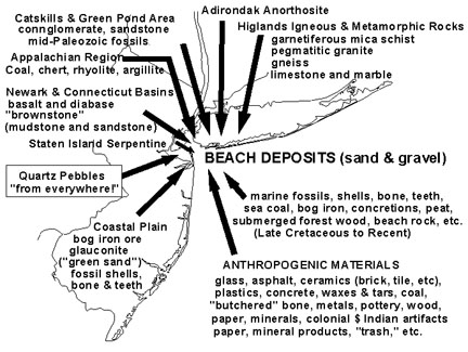 |
| Figure 172. Types of materials found in wrackline deposits on the beaches of the New York Bight. |
| Return to Our Transient Coastal Environment. |