69. Breezy Point (Gateway National Recreation Area)
Had you planned a visit to Breezy Point before the Civil War you would have been in for a surprise. It did not exist! All the land west of the vicinity of Jacob Riis Park has formed within a little more than a century (Figure 184). This is largely because of the construction of a groin field to protect the beaches at Fort Tilden, and the placement of the Breezy Point jetty to prevent the filling of Rockaway Inlet. The sand has been contributed naturally by the westward longshore drift along the south shore of Long Island, particularly the Rockaway barrier island and sources offshore.
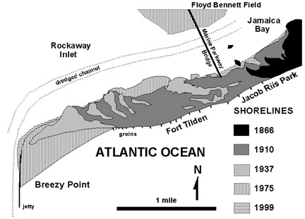 |
| Figure 184. Map showing the accretionary growth of Rockaway Spit (revised version of a NPS Fort Tilden Visitor Center display). |
The Rockaway Shore areas have been heavily utilized since colonial time. Fort Tilden began as an outer harbor defense post during the War of 1812. The site was expanded into a large defense network with ever expanding fire power beginning at the turn of the century following the Spanish American War. Fort Tilden was host to a battery of Nike nuclear missiles in the 1950s. The fort was decommissioned and eventually added to the land trust that became Gateway National Recreation Area in 1972. The move to preserve the peninsula was a response to an attempt to build high rise housing at Breezy Point in the 1960s. This was killed by environmental outcry to preserve the "natural habitat." Ironically very little of the physical landscape might be considered truly natural. Had the shore processes been allowed to proceed naturally, it is likely that Rockaway would be continuous with Coney Island, and a new inlet to Jamaica Bay would have opened elsewhere. However, we are very fortunate to have the new, nearly three-mile stretch of beach east of Jacob Riis Park. It is a gem for nature lovers, especially beach combers and bird watchers, seeking an uncrowded beach (except on summer holidays and weekends). The lack of subway access, implementation of parking fees, and the prohibition of swimming in the groin field generally keep the crowds away.
Wrackline debris yields interesting information about the history of transgression along the south shore of Long Island (specifically Queens). Fossils found on the beach include oysters, crabs, bay scallops, and dog whelk (a small gastropod). A radiocarbon date from oyster shell in concretions from Rockaway Beach yielded an age of 7,610 (±150) years before present (see Figures 149-152). A variety of vertebrate material from wild pigs, deer, elk, seals, sea lions, and American walrus were also found (all but deer, seals, and sea lions are now extinct in the region). In addition, Indian artifacts are quite common within the wrackline debris (Figures 185 and 186). It is evident that this material is washing ashore from source areas now offshore. No doubt pre-Columbian tidewater communities inhabited coastal areas. Much of the clinker (baked clay) may be from the fires in their coastal camps or villages. Occasionally, partially mineralized cedar stumps wash up onto the beach. These are all an indications that the shore is continuing to progress landward.
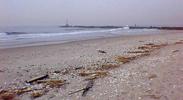 |
| Figure 185. A wrackline formed on the beach at Breezy Point. The dark line on the horizon is the Breezy Point jetty built in the early 1970s. |
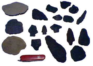 |
| Figure 186. Stone Indian artifacts washed up on the New York beach after storms. The occurrence of these materials on area beaches is an indication that sea level is progressively rising. A rich archeological record is probably submerged offshore. Artifacts are made from chert derived from the Valley and Ridge region, and local granite and schist. Many rocks of "consistent shape and lithology" may have been artifacts in the past, but have been partially or completely degraded by wave erosion. The Swiss army knife is four inches for scale. |
Fragments of pottery and glass from colonial to the early 19th century are fairly easy to recognize on Rockaway Beach. Some of this debris came from Hog Island, an early 19th century resort community built on a small barrier island that was present just offshore Rockaway Beach (a couple miles east of Jacob Riis Park). This island, including its resort community, completely vanished during a hurricane in 1893. Other islands existed in the area offshore from Coney Island. These islands also disappeared after storms, but their erosion was hastened by the activities of early settlers. The beach dunes were heavily grazed by cattle and hogs, and their cedar and holly forests were cut for fence and firewood. Be courteous with park rules when you find important or unusual material (fossils are artifacts). Removing them separates them from their place of significance, but destruction by erosion or construction is equally bad. Laws exists to protect these resources, but hopefully a little wisdom goes a long way. Future museum collections may desperately need what you find.
Public access to the beaches at Fort Tilden and Breezy Point is possible from the beach parking area at Jacob Riis Park. To get there, take the Belt Parkway's Flatbush Avenue exit south toward the Rockaways. The Marine Parkway Bridge, just south of Floyd Bennett Field, is a toll bridge. At the south end of the bridge, bear left to go to Riis Park, or go right to Fort Tilden. Turn left at the first light to get to the Fort Tilden Visitor Center. Parking via permit is possible at Fort Tilden and in a public lot at the west end of Breezy Point, however, be sure to stop at the Visitor Center at Fort Tilden before parking or walking on the beach or the trails through the old fortifications. Certain access restrictions are applied, especially during shore bird nesting season, and summer beach season. Breezy Point is a private community; access and parking are controlled.
| Return to Our Transient Coastal Environment. |