Geologic Setting of the Modern Shore
The geologic processes affecting the modern coastline are influenced by many factors. Perhaps of primary significance is the geometry of the shoreline and the bathymetry of the shallow continental shelf in the New York Bight (Figure 167). The modern landscape is a function of the region's geologic history, structure, the character or the rocks and sediments, and erosional processes. Perhaps of greatest importance are the effects of the most recent glacial advance followed by the Holocene Flandrian transgression. Bathymetric maps show that the sea bed is shallow, with only minor relief extending gradually far offshore. The topographic variation of the seabed is probably most similar to the gradual relief of the southern New Jersey coastal plain. There are sand and gravel ridges in the offshore areas that are the eroded and reworked remnants of barrier islands that formed during the early Holocene. Little is known about these sand ridges other than that they remain relatively stationary. In general, they are scoured by storm currents during the winter, and rebuilt by calmer currents in the summer. The steepest bathymetric gradient of the inshore region in just offshore the Atlantic Highlands at Sandy Hook, where the submerged ancient Hudson River Channel is closest to land. The gradient on the Long Island side of the Bight is much more gently inclined. As a consequence, a minor rise in sea level would have a much more dramatic effect on coastal Long Island than at the Atlantic Highlands region of New Jersey.
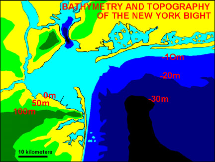 |
| Figure 167. Topography and bathymetry of the inner New York Bight region. |
Most of what is know about seabed processes in the offshore region comes from long-term studies of large offshore dumpsites and dredging maintenance of the shipping channels that extend from the harbor to the deeper portions of the shelf. The amount of anthropogenic material and dredgings dumped offshore isn't known, but it probably dwarfs the combined volume of materials contained in all onshore landfills in the New York Bight region. This staggering volume of material consists of dredged sediments from the shipping channels, construction materials (including excavation and demolished building materials), cinders from coal furnaces (including residential, industrial, and power plants), and garbage. Although ocean dumping was banned in the 1970s it is practically impossible to monitor. Anthropogenic materials have practically filled the inshore regions of the Hudson River channel (in several dump sites offshore from Sandy Hook area) to the point that it has become an obstruction to shipping. Marine currents are reworking these materials throughout the continental shelf. Much of the cinder, construction materials, and garbage washing up on area beaches are the result of both past (legal) and more recent (illegal) offshore dumping.
The currents that influence the seabed and the coastal areas are complex (Figure 168). Currents affecting the seabed on the continental shelf in the outer regions New York Bight are influenced mostly by eddy gyres from the northward flowing Gulf Stream. Thermal patterns observable from satellite images show that this current is highly variable, but it generally follows a westward back-flow motion into the inshore region of the Bight.
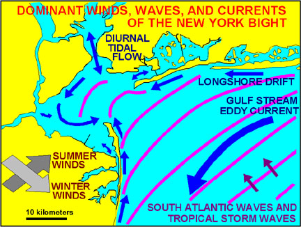 |
| Figure 168. Dominant winds, waves, and current patterns of the New York Bight. |
The inshore regions of the Bight are most greatly affected by wave energy that modifies the shallow seabed and the shore areas. In addition, the inshore regions are influenced by tidal currents (generated by the twice-a-day tug of the moon's and sun's gravity on the ocean). Gravitational tides have their greatest impact in the regions where in-flow (flood tide) and out-flow (ebb tide) are restricted, particularly in channels opening to larger bays. Tidal currents can become quite strong during the periods of greatest tidal range (spring tides). For instance, the deepest point of the modern Hudson River drainage is beneath the Verrazano Narrows Bridge. This narrow passage between the Outer and Inner New York Harbor areas is scoured by the diurnal tides flooding the inner bays. Likewise, tidal currents are quite strong in the restricted inlets that allow tidal flow through barrier islands to the lagoons on the shoreward side. The tidal range and peak varies considerably. The mean range between average low and high tide varies between 4 to 8 feet, depending on location. The incongruent timing of tidal cycles creates a complex system of "plumbing" through the region's bays, sounds, estuaries, and rivers. Tidal pumping flushes the bays with fresh marine waters on cycles ranging form 6 to 60 days or more, (depending on location). Except near the mouths of rivers, tidal driven water supply is generally more significant than the volume of water transported into the bays from rivers. The mixing of fresh and marine water by tidal currents creates a complex transitional range of biological environments for species with limited tolerance for either fresh, brackish, or fully marine water. Unfortunately, very little is understood about natural environmental systems in the New York Bight. Most seemingly, "natural environments" have been completely altered in a variety of ways: by anthropogenic modifications of coastal areas, introduction of alien species (both plants and animals), the voluminous rerouting of freshwater (mostly in the form of treated wastewater and untreated runoff), pollution, and perhaps by other unknowns.
Waves are generated by wind blowing across the surface of the ocean. Wave energy is influenced by three independent factors: wind speed, duration, and fetch. The greater the wind speed, the greater the wave energy. The longer the wind blows across the water surface (duration), the greater the wave energy. As the surface area exposed to the wind (fetch) increases, wave energy increases. However, the story of waves is somewhat more complex. Once a wave is generated it can travel practically indefinitely across the surface of the deep ocean. Wave energy is dissipated when it encounters the seabed.
Waves with longer wavelengths (the distance between crests) travel faster and farther than waves with shorter wavelengths. In fact, the longer the wavelength, the greater the energy! During a calm day in the summer there may be large waves crashing on beaches throughout the New York Bight. This is because most waves we see crashing on the area beaches are generated by winds blowing across the open ocean in the South Atlantic (below the southern tips of Africa and South America and north of Antarctica). In this region, the prevailing wind blows constantly across a surface of expansive fetch. Some of this wave energy is transferred northward in the form of "swells" (gentle waves with long wavelengths) that travel essentially unhindered until they reach the New York Bight. Here they enter the Bight from a southeast direction. During the summer, additional waves reaching the area beaches are generated by tropical storms and hurricanes. Even though these storms may be far away, the waves they generate can travel great distances.
Waves can be influenced by wind climates blowing from many different directions during the course of their travel. The modification of waves by different wind climates is too complex to describe here, however, the waves generated by local storms generally have shorter wavelengths and higher amplitudes. These waves can be traveling in a completely different direction from the longer wavelength swells generated in the South Atlantic. In time, however, some of the energy of these shorter wavelengths are transferred to the longer swells.
Waves of longer wavelength and higher amplitude possess greater wave energy. This relationship is extremely important to the understanding of coastal processes (Figure 169A). In deep water, waves of oscillation pass any point on the sea surface without the expenditure of energy, and particles in the water move in a circular motion. Wave energy begins to dissipate when a wave approaching the shore reaches water depths equal about one of its. As waves approach the shore, drag on the sea bed slows their velocity. This attenuation translates into heightened wave amplitude. As the waves grows vertically their slopes reach a critical angle. At this point the wave "breaks" (curls and crashes). The chaotic surf continues shoreward in the form of a "wave of translation" as wave energy continues to dissipate until it ends as swash on the beach.
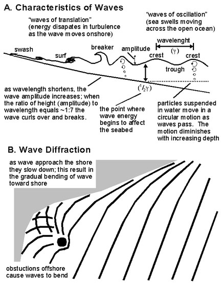 |
| Figure 169. Characteristics of waves and wave diffraction. |
Waves generated by local storms tend to have shorter wavelengths and higher amplitudes, whereas the waves associated with long-distance traveling swells have longer wavelengths. These differences have significance when examining the dynamics of beaches. Locally generated storm waves, because of their shorter wavelengths, can approach closer to the beach before dissipating their energy. In this manner, the beaches tend to endure greater erosion during storms, particularly during the winter when nor'easters with longer duration occur. In general, beaches tend to be eroded during the winter, with the sand being redeposited on offshore bars. During calm weather, typically during the summer, the longer wavelength swells gradually scour the offshore bars and redeposit the sand back on the beach. This complex process is also influenced by tidal cycles. Offshore bars formed during storms gradually migrate back onto the beach. During low tide this can be frequently seen on beaches where an offshore bar becomes exposed. The trough in between is called a runnel.
When a wave approaches the beach at an angle it is diffracted slightly toward the beach (Figure 169B). This "bending" of the wave is a result of the translation of "wavelength energy" to "amplitude energy" (and the slowing of the speed that the wave travels). However, as a wave crashes at an angle along a beach it generates a nearshore current parallel to the shore. Also, as waves roll up on the beach they pick up and move sand. With the angular translation of wave energy against the shore the results is the down current transport of sand. This process is called longshore drift (or littoral drift). Sand is constantly moving along the beaches in the region, driven by wave energy. The prevailing wave pattern illustrated in Figure 168 shows that longshore drift moves sand northward along the beaches of New Jersey, resulting in the formation of Sandy Hook Spit where the sediment flux reaches the mouth of Raritan Bay. Along the south shore of Long Island the prevailing wave pattern causes the longshore drift to build up spits in a westward direction. This results in the formation of spits such as those found at Robert Moses State Park, Breezy Point of the Rockaways in Queens, and Coney Island and Seagate at the mouth of the harbor in Brooklyn.
The opposing directions of longshore drift on the New Jersey and New York sides of the Bight are contributing to the gradual buildup of sand deposits at the mouth of the harbor. Tidal currents are keeping the sand out of the lower bay. In general, the sand forming the spits on Long Island are mostly derived from the reworking of glacial deposits (enriched in the mineral garnet derived from rocks in the Highlands Province). The sand on New Jersey beaches is derived from the reworking of coastal plain deposits (enriched in the mineral, glauconite derived from Late Cretaceous and Tertiary sedimentary formations). On the beaches in the Outer Harbor region the sand is well mixed with sediments derived from both New York and New Jersey sources. Evidence to support this is suggested by fossils and glauconite derived from New Jersey mixed in the sands on Rockaway Beach (NY), and garnet derived from Long Island glacial deposits occurs in abundance on Sandy Hook (NJ).
Whereas the buildup of these spits reflects progressive sedimentation at the end of both mainland beaches and barrier islands, this sand is being eroded at the expense of up-current beaches and offshore sand reservoirs. This natural progressive erosion is the chief concern of coastal home owners and land managers. The general lack of understanding (or complete disregard) of these processes of coastal erosion can perhaps be measured indirectly by the amount of money (taxes, private funds, and insurance claims) spent on repairing coastal properties and infrastructure!
| Return to Our Transient Coastal Environment. |