The Sedimentary Appalachians
Whereas the Highlands Province represents part of the "Crystalline Appalachians," (a region underlain by ancient metamorphic and igneous rocks), the region to the north and west of the Highlands is underlain by flat-lying to steeply folded and faulted Paleozoic sedimentary rocks. This region is referred to as the Sedimentary Appalachians, or by an older name, the Appalachian Basin (Figure 51). These Sedimentary Appalachians encompasses an extensive region underlain by sedimentary rock which extends from the Catskills region of New York, south and west along the trend of the Appalachian Mountains though Pennsylvanian, Maryland, West Virginia, Virginia, into the Tennessee/Alabama border region. The eastern margin of this region borders the crystalline rock core of the Appalachian Mountains which includes the Highlands Province in the New York Bight region and equivalent crystalline rocks of the Blue Ridge Mountains and the Piedmont Province to the south. The eastern portion of the Sedimentary Appalachians region features a series of great folds of sedimentary rock which are responsible for the characteristic topography of the Valley and Ridge Province. These folds formed during the Alleghenian Orogeny of the Late Paleozoic (beginning in the Late Mississippian and lasting through the Permian) and are imprinted on strata of Paleozoic age (Cambrian to Pennsylvanian). West of the Valley and Ridge Province is the Appalachian Plateau, a vast region underlain by nearly flat-lying sedimentary rock. Throughout the Sedimentary Appalachians region (And particularly on the Appalachian Plateau) is a thick sequence of coal-bearing sedimentary rocks of Late Mississippian to Permian age. The sediments associated with these coal measures were derived from the uplift of the Appalachian Mountains during the Alleghenian Orogeny.
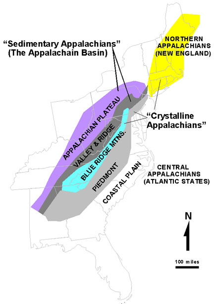 |
| Figure 51. Map of the Appalachian Mountains region showing the outcrop belts of the "Sedimentary Appalachians" (also called the Appalachian Basin, and represents a vast region underlain by Paleozoic sedimentary rocks), and the."Crystalline Appalachians" (underlain chiefly by Precambrian and Early Paleozoic metamorphic and igneous rocks). |
Because the "Sedimentary Appalachians" encompass such a broad region, discussion in this text is limited to the Valley & Ridge Province located on the "western fringe" of the New York City region. The geology of the Valley & Ridge Province is described on the next page.
Field Trips to the Sedimentary Appalachians
With luck, and by getting an early start, it is possible to avoid most traffic headaches and swiftly escape the city. Within two hours of crossing any of the bridges and tunnels that leave Manhattan to New Jersey it is possible to be at any of the selected locations described below. Whereas there are many other possible destinations to choose from, the sites selected below are included to present a general overview of the geologic history and character of the Sedimentary Appalachians region. However, it would take many days to adequately enjoy all the sites described below.
Hudson River Valley Region
The Catskills Mountains
24. North Lake State Park
25. Kaaterskill Falls
26. Catskill Road Cuts
27. Route 209/Sawkill Road Outcrops
The Shawangunk Mountains, New York
28. Mohonk Preserve (Shawangunks)
29. Minnewaska State Park
The Green Pond Outlier, New York and New Jersey
30. Highland Mills
31. Bearfort Mountain
Kittatinny Mountain, New Jersey and Pennsylvania
32. Delaware Water Gap National Recreation
Area
33. Coppermines Trail
34. Pocono Environmental Education Center
35. Stokes State Forest
36. Tillman Ravine Natural Area
37. High Point State Park
38. Port Jervis Gorge
| Return to Valley and Ridge Province Main Page. |