35. Stokes State Forest
Stokes State Forest is a continuation of the public lands protecting the scenic ridge of Kittatinny Mountain in northwestern New Jersey. The park was established in 1907 by the New Jersey Forest and Parks Commission, and has grown through the addition of tracts to its current size encompassing over 15,000 acres. Although the forests were cut heavily in the 19th and early 20th centuries, logging on Kittatinny Mountain has been curtailed for protection of watershed and scenery. Many red and white pine forests within the forest preserve were planted by the Civilian Conservation Corp in 1930s in abandoned farm fields. These tall pine groves are quite numerous in the area, and can be easily recognized by the neat, straight lines of tall pines.
A stream gap is responsible for the route of Highway 206 across Kittatinny Ridge through the heart of Stokes Forest (see Figure 72 on the Delaware River Valley page). The geology of the park is essentially the same as the Delaware Water Gap with Paleozoic sedimentary rocks dipping steeply to the west with the Silurian Shawangunk Formation forming the resistant core of the ridge (see Figure 73 on the Delaware Water Gap page). The same discussions relating to the formation of the Delaware Water Gap can be applied to the water gap at Stokes Forest.
The area around Stokes Forest has a long history of mining attempts; none of them proved to be significant. Mine prospects in the area have yielded traces of lead, silver, gold and copper, but not in economically recoverable amounts. One operation, the Snook Mine, was dug in the 1880s by its proprietor, John Snook, who actually discovered a vein bearing silver ore. He reported to have been paid $75.00 per ton for his ore, but by the size of the deposit must have not been significant. The flooded shaft for this abandoned mine is along a trail about a mile in length that begins at the Kittle Field picnic area. This picnic area is located on Coursen Road about 1.5 miles north of the Stokes State Forest Office just off of Route 206. The first part of the trail leads to a waterfall and an early 19th Century mill site and is accessible for disabled persons. Beyond the falls the trail is fairly rough. There are also has numerous other trails that traverse the mountainside and along streams in the Delaware Valley below (get a map from the visitor center).
Sunrise Mountain Road is a one-way loop road winds along the crest and hillsides of Kittatinny Mountain. It begins on Route 206 about three-fourths mile east of the Stokes State Forest Office and ends six miles to the north at Steam Mill Camping area (see Figure 72). Along the way are scattered overlooks that provide stunning views of the Delaware River Valley and Pocono Mountains to the west. At the crest of the mountain is the Sunrise Mountain Overlook that, at an elevation of 1653 feet, provides a panoramic view of Kittatinny Valley and the New Jersey Highland to the east (Kittatinny Valley is the local name for the Great Valley in northern New Jersey). The overlook is an access site for the Appalachian Trail. Glacial erratics and bedrock exposures along the trail near the overlook are Silurian Shawangunk Conglomerate (Figure 77).
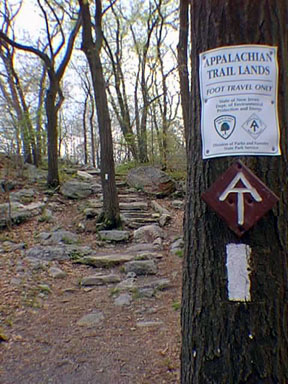 |
| Figure 77. The Appalachian Trail winds among glacial erratics along the crest of Kittatinny Mountain in Stokes State Forest, New Jersey. |
The Tinsley Trail Geologic Area features glacial deposits and post-glacial weathering and erosion features along the western hillside of Kittatinny Mountain. The Tinsley trailhead is located on Sunrise Mountain Road 3.5 miles north of the intersection with Route 206. The trail leads down the west side of Kittatinny Mountain. The trail turns right at a trail intersection about a half mile from the road. In another half mile the trail leads to a recessional moraine of the Late Pleistocene glacier. Glacial features include a multitude of small mounds and parallel ridges consisting of unstratified till, and numerous large kettle holes. Kettles are large depressions that formed where glacial ice was buried beneath morainal material, then melted to form a water-filled depression. Many of these are still ponds in varying stages of succession of filling in. The glacial till consists mostly of locally derived material: the white-to-gray Silurian Shawangunk Conglomerate, and the reddish sandstone of the Late Silurian Bloomsburg Red Beds. Amongst the debris are boulders and cobbles of an igneous rock called nepheline syenite. This rock is known from outcropping in the vicinity of Beemerville, New Jersey, about four miles to the north on the east side of Kittatinny Mountain. One known intrusion in that area occurs along the contact between the Ordovician Martinsburg Shale and the base of the overlying Shawangunk Formation. Other intrusive bodies are known in the region around Beemerville, and probably intruded into the Great Valley region sometime during the period between the Late Silurian to the Late Devonian.
Along the Tinsley Trail about a 1.5 miles north of the road is a large periglacial rock field. This is an area where the surface is covered with large semi-rounded glacial and bedrock boulders. These rocks accumulated on the surface after thousands of freeze-thaw cycles gradually heave rocks to the surface. The finer soil material is washed away, so plants have great difficulty becoming established. Such rock fields are common in areas where sandstone bedrock occurs in cool or cold climates. In places, the freeze thaw cycle moves these rocks down hill in the form of a "rock glacier," heaping them to greatest thickness at the base of a talus slope. Smaller boulder fields are common along the higher elevations of Kittatinny Mountain (Figure 78). These rock fields are considered "periglacial" phenomenon. The term, periglacial, is applied to processes, conditions, areas, climates, and topographic features at the immediate margins of glaciers and ice sheets, and are influenced by the cold temperature of the ice. It also applies for areas where frost action is an important factor. The fact that these areas are barren of vegetation suggests that the movement of the rock is still active. One of the largest and impressive rock glaciers in the region is located in Hickory Run State Park located just south of I-80 about 25 miles west of Stroudsburg, Pennsylvania.
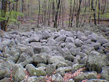 |
| Figure 78. A periglacial boulder field on Kittatinny Mountain along the overlook road eat of Walpack Valley Environmental Education Center, Delaware Water Gap National Recreation Area, New Jersey. |
| Return to Valley and Ridge Province Main Page. |