The Catskills
The Catskills Mountains are an northeast extension of the greater Allegheny Plateau in southern New York. The outcrop belt of the Late Devonian Catskill Group forms the Catskill Mural Front, the strikingly steep eastern side of the Catskill Mountains that rises to around 2,000 feet in elevation just west of Kingston and extends northward to the area north and west of Catskill, New York (Figure 57). The Catskills are an erosionally dissected plateau, with 98 peaks that rise over 3,000 feet in elevation. Slide Mountain, highest point in the Catskills, is 4,180 feet in elevation. Many bedrock exposures in the upland areas display evidence of the scour of glacial ice, indicating that during periods Pleistocene glaciation the entire Catskills region was submerged in ice.
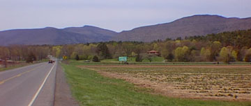 |
| Figure 57. The Catskill Mural Front from along Route 23A east of Palenville, New York. The gorge bisecting the front is the Kaaterskill Clove - a canyon carved by stream erosion after the continental glacier melted. North Lake State Park encompasses the mountain to the right of the gorge. |
The Catskill Mural Front bends sharply to the west near Kingston, and continues to the southwest, but grows progressively less distinct at the clastic units generally gradually become more finer grained. In Pennsylvania, the sedimentary strata of the Catskills Group form the bedrock of the Pocono Mountains. All bedrock in the region consists of reddish to greenish colored sandstone, shale and conglomerate of Late Devonian age. The rocks along the eastern flank of the Catskills are generally unfossiliferous with exception of fossil wood in some horizons.The northern Catskills region is a Devonian fossil hunters paradise, with numerous formations representing different shallow marine, transitional, and non-marine depositional environments. A famous fossil forest locality is located in an excavation for Gilboa Reservoir in the northern Catskills. Several hundred stumps of Gilboa fern trees in growth position were excavated and donated to colleges and museums around the country.
The Catskills region experience a heavy timber exploitation well into the late 19th Century. Harvested areas were sold off to mountain farmers who would raise crops and livestock until the soil was essentially depleted. With the expansion of the railroad, the Catskills became the destination of summer vacationers. Conservation movements that followed resulted in the creation of the Catskill Forest Preserve in 1885.
The Catskill Forest Preserve has grown through time to encompass almost 300,000 acres. Within this preserve, the land is designated watershed, ecological and scenic reserve areas, and recreational lands Although 60% of the region is privately owned, it is protected from future development. The public land within the preserve is called "Catskill Park."
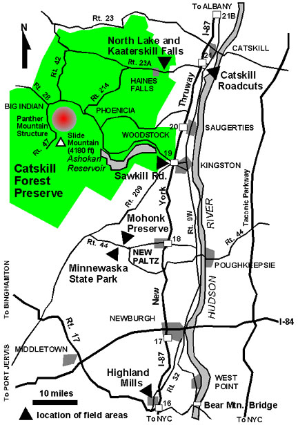
A drive through the region during the fall foliage or in the late spring when the mountain laurel is in bloom can be spectacular. A recommended circuit drive (see Figure 55) combines the drive west on Route 23A (up and over the Catskill Mural Front past North Lake State Park), to Route 214 south to Phoenicia. From Phoenicia drive west eight miles on Route 28 to Big Indian, then south on Route 47 for about seven miles to the trailhead parking area for Panther Mountain (the trailhead for Slide Mountain is an addition mile to the south). The 15 mile drive between Phoenicia and the Panther Mountain trail head follows a great ring-shaped valley that has been interpreted as the remnant of a giant meteor impact crater, called the Panther Mountain Structure, that formed after the Catskills strata had been deposited. The actual crater would have formed in a thick section of sediments that had overlain the Catskill region in Late Paleozoic time.
There are several options return drive from the Phoenicia area. One might consider returning to Exit 19 on the Thruway along Route 28 and ponder the size and significance of Ashokan Reservoir along the way (part of the New York City water supply system). Those in the mood for Rock-N-Roll Era nostalgia might want to stop in Woodstock for dinner at one of it many restaurants.
| Return to Valley and Ridge Province Main Page. |