27. Route 209/Sawkill
Road Outcrops Near Kingston, New York
Route 209 between Kingston and Port Jervis follows a series of southwestward-trending
stream valleys (Esopus Creek, Roundout Creek, Basher Kill, and the Neversink
River, north to south, respectively). These stream follow a natural saddle
in the landscape called the Port Jervis Trough. This valley follows the
strike of northwest dipping strata along the western side of the Great
Valley, a valley that formed along the easily eroded shales of the lower
Hamilton Group (late Middle Devonian). On the southeast side of the valley
are high hills and mountains consisting of the older, more weathering-resistant
dolomite and limestone formations of the Onondaga Formation and Helderberg
Group, and the even more resistant sandstones and conglomerates of the
Silurian Shawangunk Formation. To the northwest of the valley the land
rises to the height of the Catskills Plateau where the mountaintops consist
of more weathering-resistant sandstone and conglomerate of the Late Devonian
Catskill Group (also called the Genesee Group). In the 19th Century, the
lateral continuity of the streams valleys was utilized for the construction
of the Delaware and Hudson Canal.
The shales of the lower Hamilton Group is well exposed along Route 209
in a series of large road cuts between Route 28 and Sawkill Road on the
northwest side of Kingston (Figure 62 and 63). These road cuts consist
dominantly of gray, friable shale with scattered thin ledges of sandstone
and occasional silty limestone concretions. Fossil horn corals and spiriferid
brachiopods and other marine invertebrate material are not abundant, nor
are they typically in good condition. The brachiopods and corals show
evidence of damage from being transported by storm or turbidity currents
from shallower water into a deeper water setting (Figure 64).
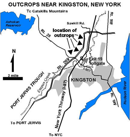 |
| Figure 62. Location of roadside outcrops near the town of Kingston,
New York. |
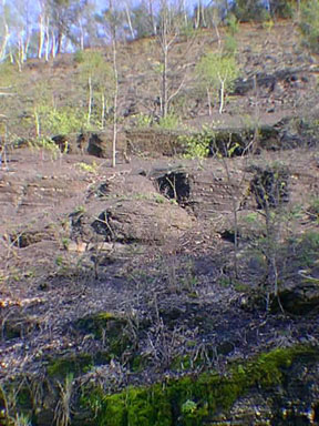 |
| Figure 63. Outcrop of gray shales and thin sandstones of the Hamilton
Group along Route 209 near Kingston, New York. |
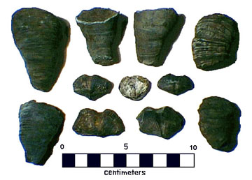 |
| Figure 64. Rugose corals and spiriferid brachiopods from the lower
Hamilton Group from near Kingston, New York. |
A look at these outcrops are worthy of a brief stop on the way to the
Catskills or the Shawangunks. Once again, there is often heavy traffic
along Route 209, and the road cuts are very steep, and consist mostly
of unconsolidated shale, so use extra caution. Other outcrops along un-posted
side roads in the area may provide safer and easier access.
|