| Switch to: |
|
|
Powell's First Expedition (1869) left familiar territory at the mouth of the Uintah River (Duchense River) on July 6th. By the next day they were already entering unexplored canyons of the Green River. The the canyon increases in depth as the river flows south through an uplifted plateau (Tavaputs and East Tavaputs). The general barren character of the canyon led Powell to name it the "Canyon of Desolation." Powell found fish fossils and recognized that the organic-rich sedimentary rocks exposed along the river were Tertiary-age lacustrine (lake) deposits. Further south, the river cuts through older strata know today as the Book Cliffs of Cretaceous age in the region of the Price River. Powell named this section Coal Canyon (now Gray Canyon) after the massive marine shale and sandstone exposures along the Green River valley. On July 13th, the First Expedition recognized "Gunnison Crossing" (now the site of Green River, Utah) and noted that Indians had recently used the crossing. They continued south into the red-rock country in what is today the Canyonlands National Park region. Powell named a very curvy section of the river, Labyrinth Canyon, and a similar but more flat-water section of the river, Stillwater Canyon. They finally reach the confluence of the rivers Green and Grand (Colorado) on July 16th, 1869, nearly three weeks ahead of Powell's anticipated schedule. |
| On the Second Expedition in 1871, Powell turned the command of the voyage through Desolation Canyon over to his brother-in-law, "Prof" Almon H. Thompson. Being later in the year, water levels were much lower in the canyon. This required more time and work to paddle boats through the still water and shallows in the canyons. Powell rejoined the Second Expedition at "Gunnison Crossing" (Green River, Utah) on August 9th with a limited supply of food. They reached the Confluence of the Green and Colorado Rivers around mid September where they spent several days exploring before continuing down Cataract Canyon. | |
 |
Green River. Cabin at "Ft. Robidoux" about opposite the mouth
of the Uintah River. Dodd's cabin, White River Valley. Figures from left
to right are: Dellenbaugh looking through field glasses, Jack Hillers
sitting down and pointing, Thompson on the arm of chair, Beaman standing
in front of door, Clement Powell on his left, J. F. Steward, Andy Hattan,
Captain Bishop near tree. Utah. 1871. Photo by E. O. Beaman. "Pardyn
Dodd's Cabin 1871. Identified by the journals of F. M. Bishop and S. V.
Jones. This has been erroneously termed Fort Robidoux in some of the Powell
journals. It was built on the site of the fort constructed sometime in
the 1830's at the mouth of the White River. Photograph by E. O. Beaman,
July, 1871." The Uintah River is shown on modern maps as a tributary of the Duchense River. Fort Robidoux was located about 30 miles west of the confluence of the Duchense and Green rivers. |
 |
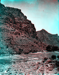
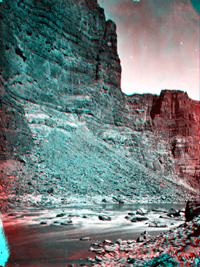
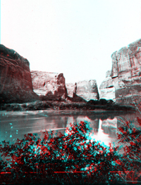
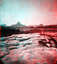
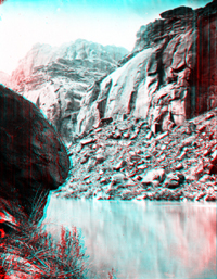
Canyon of Desolation, Green River. Utah. USGS Earth Science Photographic Archive digital file: hjk00713 Desolation Canyon is along the south side of the Uinta Basin, an asymmetrically-shaped downwarp surrounded by mountain ranges surrounding the northern Colorado Plateau. Whereas the center of the basin is near Ouray, Utah, at its maximum thickness the sedimentary strata above Precambrian basement rocks is about 15,000 feet just south of the Uinta Range. The south side of the basin is a gentle upwarp that flattens out gradually to a structural high in south central Utah in the Canyonlands National Park region. In that region, Mesozoic strata overlies an older structural downwarp called the Paradox Basin (discussed below). Traveling downstream along the Green River from Ouray through the canyon the rocks grow progressively older at stream level (the strata dips gently upstream, to the north). Three rock formations of Tertiary Age (Eocene Epoch) crop out throughout Desolation Canyon, and they are exposed youngest to oldest downstream. Near Ouray, the Uinta Formation is exposed in a region of relative low relief. The progressively higher cliffs of Desolation Canyon consist of Wasatch Formation (nearly 3,000 feet thick), and along the southern end of the canyon, the Green River Formation is exposed (also about 3,000 feet thick). These strata overlay a thin interval of Paleocene age rocks that, in turn, overlie rocks of Cretaceous rocks that croup out in Gray Canyon and the Book cliffs south of Desolation Canyon near Green River, Utah. |
 |
Chimney Rock on the Green River. 1871. USGS Earth Science Photographic Archive digital files: hjk00517 and hjk0517a Chimney Rock is an outcrop of Wasatch Formation sandstone located in Desolation Canyon about 58 miles downstream of Ouray. It was named by the crew of the Second Expedition in 1871. |
 |
Green River in Canyon of Desolation. Utah. USGS Earth Science Photographic Archive digital file: hjk00538 |
 |
Canyon of Desolation, Green River. Utah. (Negative broken). |
 |
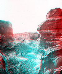
Canyon of Desolation, Green River. "Rigput fence" left foreground.
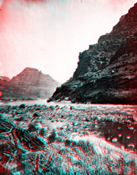
Utah. USGS Earth Science Photographic Archive digital file: hjk00716 A "rigput fence" refers to wall-like piles of driftwood that accumulate along the river during flood. They provide a running record of high-water flow, much like wracklines on a beach between high tides and storms. Before Flaming Gorge Dam and other impoundments in the river system, the magnitude of discharge could vary between 50 and 100 times between low-water flow periods in the early summer and fall, and peak discharge periods after spring snow melt, and the sometime rare heavy-wet monsoon seasons of the late summer in the region. Episodic storms in the summer may only impact portions of Colorado River basin or its tributaries. Today, the controlled release of water for daily power generation from the high dams produce "synthetic" daily tidal fluctuations |
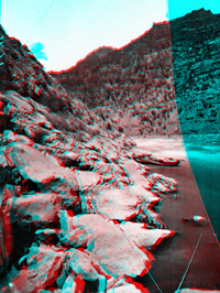 |
Canyon of Desolation, Green River. Boats of the 1871 Expedition. Utah.
(Negative broken). USGS Earth Science Photographic Archive digital file: hjk00719 Note about anaglyphic images: the red color is associated with the left image, the cyan color is associated with the right. In this case the "left" side of plate was broken, causing the cyan to stand out where part of the plate is missing (both images were typically burned onto a single plate negative in the camera equipped with dual lenses). When red and cyan are combined in the images, the result is a gray-scale palette (white to black). The aged original photographs also had brownish tones that come through in many of the images. Unusual shaped patches of red or cyan color are usually imperfections in the original negative plates, either scratches or where the coating may of rubbed off or were imperfectly prepared before exposure. Considering the time constrains, methods involved, and circumstances required to take and transport the glass plates, cameras, and photographs supplies, the survival of so many scenes is a reflection of the remarkable dedication to the photographic aspects of the expedition. |
 |
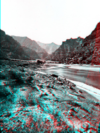
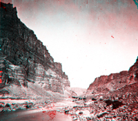
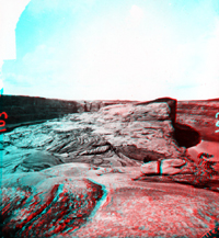
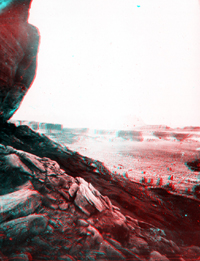
Low water in Green River, Canyon of Desolation. Utah. Note the low level of the Green River in these Rapids. Powell's brother-in-law, the "Professor" Almon H. Thompson got the job of leading the Second Expedition through the canyon during the heat of August, 1871. Low water meant more rowing, dragging, and portaging the boats downstream through the generally shade-free canyon. Note the steep, blocky talus cones that extend from the cliff face directly to the river in many of the thumbs. For much of the canyon there is little room for plant communities to become established along the canyon bottoms. |
 |
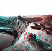
Green River in Canyon of Desolation. Utah. USGS Earth Science Photographic Archive digital file: hjk00749 The sharp contrast between these units probably reflect the formation boundary between the Wasatch Formation and the overlying, darker, more organic-rich Green River Formation. These strata formed from deposits laid down in the subsiding Uinta Basin during the Laramide Orogeny. The Wasatch Formation represents inter-fingering sedimentary deposits (gravel, sand, and mud) that accumulated in stream channels, on floodplains, or in swamps or lakes, whereas the Green River Formation represents sediments deposited in a great lake basin that extended throughout northwestern Utah and parts of western Colorado and southwestern Wyoming. Through time, "Green River Lake" fluctuated with climatic conditions, ranging from freshwater to hypersaline conditions. At times, extensive algal reef formed along margins of the basin. In addition, stagnant water at depth allowed organic-rich sediments accumulated in the lake bed. Concentrations of organic material in some sections of the Green River Formation are rich enough to burn freely if ignited. |
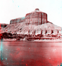 |
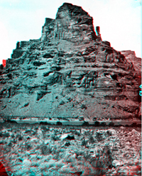
Dellenbaugh Butte, Green River, near the mouth of San Rafael.
Utah. USGS Earth Science Photographic Archive digital file: hjk00585 The confluence of San Rafael Creek and the Green River is about 15 miles south of the town of Green River, Utah and about 20 miles north of Canyonlands National Park. It marks the boundary between Gray Canyon (to the north) and Labyrinth Canyon (to the south which extends into the park.) Traveling downstream from Green River, Utah, the river cuts into increasingly older rock. Dellenbaugh Butte (named after Frederick Dellenbaugh, an artist-crew member from the First Expedition) consists of Jurassic sedimentary formations. Starting at river level, Quaternary and recent alluvium and aeolian deposits form a 20-foot high terrace along the river bank. Sandstone of the Entrada Formation crops out just above this lower alluvial bench. Talus covers the Curtis Formation. The even-bedded section above the talus slope is Summerville Formation. The small cap on the butte consists of sandstone of the Salt Wash Member of the lower Morrison Formation. These formations preserve evidence that coastal floodplains, mudflats, dunes, and beaches existed along the margin of a shallow seaway during Jurassic time. |
 |
Green River at Labyrinth Canyon. Utah. Photo by E. O. Beaman. USGS Earth Science Photographic Archive digital file: hjk00728 This picture is actually near the mouth of Labyrinth Canyon at Trin Alcove Bend. Trin Alcove Bend is located about 29 miles south of "Gunnison Crossing" (at Green River State Park in Green River, Utah). Canyon cliffs consist of Navajo Sandstone. When this location was photographed again by Hal G. Stevens in 1968, the barren sandbar extending to near the center of the river from along the left side of the stream was mostly missing except immediately along the cliff face where a narrow floodplain and slope is stabilized by dense vegetation. |
 |
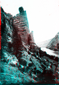
Trin Alcove, Labyrinth Canyon, Green River. Utah. USGS Earth Science Photographic Archive digital files: hjk00722 and hjk0722a Rocks exposed at the surface along the Green River grow progressively older downstream toward the Confluence of the Green River with the Colorado River (also called the Grand River in during Powell's Expedition). Trinal Alcove is located about 2 miles downstream of the entrance to the section of canyon that Powell named "Labyrinth Canyon." The Second Expedition camped here on September 8, 1871 and spent time exploring the canyons in the vicinity. Cliffs in this section of the river consist of Navajo Sandstone (latest Triassic to Early Jurassic in age). |
 |
Trin Alcove, Labyrinth Canyon, Green River. Utah. USGS Earth Science Photographic Archive digital file: hjk00723 Massive beds of Navajo Sandstone display vertical dark streaks called "desert varnish." Desert varnish consists of a surface coating of manganese and iron hydroxide mineral precipitates, probably derived from leaching of soils on the tops of the cliffs. Desert shrub oaks and occasional cottonwoods grow along the shady side canyons of the Green River. |
 |
Trinal Cove Bend, Labyrinth Canyon, Green River. Utah. USGS Earth Science Photographic Archive digital file: hjk00727 A cliff-top view of Trin Alcove Bend shows the flat upland plateau above the Green River. The upper Navajo Sandstone displays massive crossbeds reflecting the widespread desert dune environment that existed across the much of region that is now Utah in Early Jurassic time. |
 |
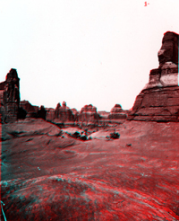
Bowknot Bend, Labyrinth Canyon. Utah. E. O. Beaman took this photograph from the west end of the narrow saddle of Bowknot Bend (located about 48 miles downstream of "Gunnison Crossing" at Green River State Park, Utah). Only 1,200 feet separates the river channel, even though the path of the river channel continues 7.5 miles in a circular loop. The saddle is along the crest of a gentle structural upwarp called the Cane Creek Anticline. This region is part of the Paradox Basin, an older structural basin that formed along the western side of the Ancestral Rocky Mountains in Pennsylvanian and Permian time (much earlier that the uplift and subsidence that occurred during and following the Laramide Orogeny that formed the Uinta Basin and modern Rocky Mountains that we see today). Massive deposits of salt and gypsum occur deep in the subsurface here; flowing salt under pressure forms many of the structures in the region (a process that is still occurring). Cliffs along the river consist of Triassic-age Moenkopi Formation capped by Chinle Formation. In the distance sheer cliffs roughly 300 feet high consist of Wingate Sandstone capped by Kayenta Formation, both of Late Triassic age. |
 |
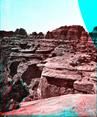
The Butte of the Cross. Labyrinth Canyon, Green River. Utah. USGS Earth Science Photographic Archive digital file: hjk00733 Butte-of-the-Cross is located on the west side of the Green River (near Bonita Bend and Anderson Bottom on the Green River along western edge of Canyonlands National Park). E. O. Beaman took this picture on September 18, 1871 from the top of a bluff of White Rim Sandstone of Late Permian age. The Butte-of-the-Cross, and other distant escarpments and mesas, consist of the complete Triassic stratigraphic section, ascending in order: Moenkopi Formation (cliff), Chinle Formation (slope), Wingate Formation (cliff), Kayenta Formation (cliff), and Navajo Sandstone. |
 |
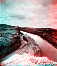
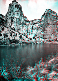
View near Bonita Bend in Green River. Utah. USGS Earth Science Photographic Archive digital file: hjk00739 The Second Powell Expedition stopped at Bonita Bend on September 12, 1871 (located 86 miles downstream of "Gunnison Crossing" at Green River State Park, Utah). They recognized that Anderson Bend (nearby) is a cutoff stream meander that formed when the Green River cut through the neck in a bend in the river. The flat water through this section of the river canyon prompted Powell to name it Stillwater Canyon. Stillwater Canyon extends from just above Bonita Bend to the rapids just above the Confluence of the Green and Colorado rivers. |
 |
Green River in Stillwater Canyon. Utah. USGS Earth Science Photographic Archive digital files: hjk00657 and hjk0657a Despite concerns about dwindling food supplies, the deep, slow moving water in Stillwater Canyon came as a relief to both Powell expeditions. It served as a reprieve to the hard work paddling and portaging associated with rapids that were in flood during the First Expedition, and the low-water conditions that exposed rocks and sand bars in the stream during the Second. Note the clear-water conditions in this image in contrast to the muddy water in the following thumbs. A summer rainstorm (with flash floods) will turn the river completely muddy in a matter of hours. |
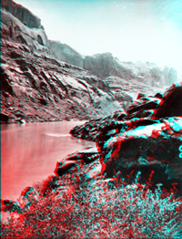 |
Green River in Stillwater Canyon. Utah. USGS Earth Science Photographic Archive digital files: hjk00831 and hjk0831a The white caprock along Stillwater Canyon displays dark streaks of desert varnish that are typical on the White Rim Sandstone (late Permian). The White Rim sandstone stands out in contrast to the reddish beds of the underlying Organ Rock Formation (Permian) and the overlying Moenkopi Formation (Triassic). The softer shales of the Moenkopi Formation weather and erode faster than the underlying White Rim Sandstone. As a result, the White Rim Sandstone forms a caprock ledge along the Green and Colorado River gorges throughout much of the Canyonlands National Park region. They are particularly visible from overlooks throughout the Island-In-The-Sky District. |
 |
Green River from Junction Cliff in Stillwater Canyon. Utah. Wayne and
San Juan Counties, Utah. 1871. USGS Earth Science Photographic Archive digital file: hjk00774 Within 15 miles of the Confluence, cliffs along the Green River contain thin lenticular beds of limey mudrock bearing crinoids, brachiopods and other marine fossils. These beds are within the Rico Formation of Pennsylvanian age. The Rico Formation overlies the Paradox Formation that is only partially exposed downstream in parts of Cataract Canyon. These rocks represent the oldest formation exposed in the canyon system between Dinosaur National Park and Marble Canyon. |
 |
On the top of the country immediately at the junction of the Grand (now
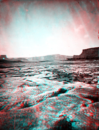
Colorado) and Green Rivers, west side. Utah. September 17, 1871. The region east of the Confluence of the Green and Colorado rivers is called the Needles District of Canyonlands National Park. It is a region known for slick-rock expanses of in the Organ Rock Sandstone and towering spires of the overlying Cedar Mesa Sandstone (both of Permian age; and both are visible in this image). Despite dwindling food supplies, the Second Powell Expedition took time in late September 1871 to explore the rugged upland region around the Confluence of the Colorado and Green rivers. |
 |
Colorado River. Junction of Grand (now Colorado) and Green Rivers, just
west of the junction. Utah. (No water shown in photo). (Negative broken).
USGS Earth Science Photographic Archive digital file: hjk00747 The Organ Rock Sandstone (middle Permian) forms the core of the upland canyons in the Confluence area, particularly through the Needles District of Canyonlands, east of the river. In real color, the strata consist of reddish brown and white beds of arkosic sandstone ("arkosic" means that the sediments are rich in grains of feldspar minerals). The reddish color comes from a high hematite and other iron-oxide minerals that cement the sand beds that are locally cross-bedded. The arkosic content suggests that the original sediments were likely derived from the "Uncompahgre Uplift" region, an ancient upwarp that formed during Pennsylvanian and Permian time throughout the western Colorado region. This upwarp shed sediments into surrounding basins, including the Paradox Basin, from Pennsylvanian through early Triassic time. The source of much of the sediments where ancient uplifts that existed in the Colorado Front Range region (called the "Ancestral Rockies" that included the Uncompahgre Uplift). These uplifts eroded away and/or were buried by younger sediments derived from mountain ranges forming to the west in the Cordilleran region and possibly as far east as the Appalachian region. |
 |
Labyrinth Canyon, Green River, Tump-in-kon-tu-weap. Utah. Click here to see recent 3D photography of the Canyonlands National Park area. |