A collection of anaglyphic images (3D)

3D Photography of the Powell Survey (1870-1879)
|
A collection of anaglyphic images (3D) |
|
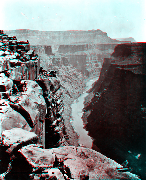 |
Click here to start a tour through the Colorado Plateau canyon country. All images on this website are derived from photography that Major John Wesley Powell commissioned to document his Second Expedition (1871-1872) and later expeditions on the Colorado Plateau. This website contains a collection of 3D "anaglyphic" images modified from original stereo photography. You will need red-and-cyan 3D viewing glasses to get the 3D stereoscopic effects. Click here to see the same tour through standard photography. This 3D view is the Grand Canyon of the Colorado River looking east from cliff top at Toroweap above Lava Falls. Click on any thumbnail image within the website to see a full-size image, or click on each large image to follow an "image tour." |
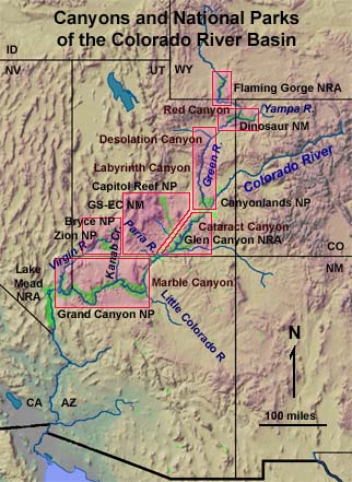 |
Click on the map or on the list below. Green River (WY), Flaming Gorge, and Red Canyon (1871) Dinosaur National Monument area (1871) Desolation Labyrinth, and Stillwater Canyons (1871) Cataract and Glen Canyons (1872) Thompson Expedition through the Paria River, Escalante Rivers, and Waterpocket Fold region (1872) Virgin River to Zion NP area (1872) Click on red boxes on map to see more detailed maps and photo thumbnail images. |
|
Note: Images range in size from 400KB to 2,500KB. Scanned images of the original stereoscopic photography in the USGS Library's Earth Science Photographic Archive in Denver, Colorado. The first paragraph of each caption is information copied from the original photo-archive notes (including image identification numbers). The second paragraphs contain additional notes that include geologic information, geographic name changes, and historic information about the location where the original photograph was taken. These have been derived from selected reference sources. Whereas Powell's First Expedition of 1869 received the most publicity,
the original stereoscopic photographs used for this website were taken
taken on the Second Expedition (1871 to 1872) and, others were taken within
the following decade during other expeditions in the Desert Southwest.
No dates were recorded in notes for many of the of the original photographs.
As a result, the images are arranged in an interpreted chronological order
based of information in reference sources and the writer's limited experience
in the field. This is only a partial collection of Powell Survey (1870-1879)
photography; only stereographic views were selected. Most of the original
Powell Survey photography is now in the National Archives (Washington,
D.C.) and in the USGS Earth Science Photographic Archive in Denver Colorado.
To learn more about John Wesley Powell and the history of the U.S. Geological
Survey, click here. Click here to see Historic 3D Photography of Yosemite National Park. Click here to learn more about the historic stereoscopic photography on this website. Click here to see a Geologic Time Scale. |
| Chick here to see more 3D Geology of National Parks. |
|
This page is <https://gotbooks.miracosta.edu/gonp/3Dcanyons/> Last modified: 1/20/2010 |