Geology of National Parks banner
American Indians of the Southwest, 1871-1875
Chick here to start a 3D Image tour of Early Photography Taken During the U.S. Geological and Geographical Surveys West of the 100th Meridian and the Powell Survey of the Colorado River Canyons.

Click here to see a Thumbnail Gallery.
Click here to see original stereograph photography (from the Library of Congress, Photographs Division).
General map of where different Indian tribes lvied ath the time of the Surveys of 1871-1875 
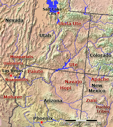
Map of the American Southwest with generalized locations where tribes were encountered during the Surveys

Click here to see national parks websites with 3D.


In 1871 Lieutenant George Wheeler was put in charge of the United States Geological Surveys West of the One Hundredth Meridian. At the same time, John Wesley Powell began his exploration of the Colorado River Canyons. Both Survey teams were tasked with collecting an accurate physical description of parts of the Southwest, including the topography and mineral resources, information on resident American Indians, and other facts valuable for settlement and economic exploitation. Both Survey crews hired field photographers and surveyors. In that era, stereo photography was extremely popular, and large numbers of stereograph images were printed, sold, and distributed around the world.

This website includes to photography of Timothy O'Sullivan, John K. Hillers, and E.O. Beaman. These men traveled alongside survey crews. Between 1871 and 1875 they photographed many American Indians posed in native dress or involved in activities of daily life.

Many thanks are extended to the Library of Congress, Prints & Photographs Division, for making the original stereographs available free to the public. (Search the Library of Congress website at http://www.loc.gov/rr/print/catalog.html to see the original stereographs.)


This website contains images produced from stereo photopairs that were manipulated into anaglyphs (3-D images). You will need red-and-cyan stereo viewing glasses to get the 3-D visual effects. Aspects of the original stereograph card borders were preserved were possible.

Learn more about the history of exploration and photography of the American West and the history of the U.S. Geological Survey from: Rabbitt, M. C., 2000, The United States Geological Survey: 1879-1989: U.S. Geological Survey Circular 1050. Available on-line at: http://pubs.usgs.gov/circ/c1050/index.htm.


Also check out historic stereo photography (also as anaglyphs) of:
John Wesley Powell's 1871-2 exploration of the Colorado River canyons
Modern and Historic 3D Photography of Yellowstone National Park
Historic Stereo Photography of Yosemite National Park


This page is <https://gotbooks.miracosta.edu/gonp/indians/>
Last modified 9/13/2010