| Switch to: |
 |
Major John Wesley Powell's first voyage down the Green and Colorado rivers in 1869 was more of an adventure -- the trip was named the First Expedition. The Second Expedition (1871 and 1872) was dedicated to mapping and scientific exploration. It was on the Second Expedition that the Powell hired photographer, E. O. Beaman, to take landscape photography (including stereoscopy). He also hired his cousin, Clement (Clem) Powell to help on the expedition with the understanding that he would learn photography, but Clem never mastered it. Beaman's quit the survey in January 1872 and Powell hired another photographer, James Fennemore. Powell also hired an oarsman, John (Jack) K. Hillers who volunteered as an assistant to both photographers. Hillers learned the techniques of photography in the field and went on to complete the photographic mission of what became known simply as the Powell Survey. The Powell Survey (1870-1879) was formally known as the United States Geological and Geographical Survey of the Territories - Second Division It was also known as the Rocky Mountain Survey. Powell served as director of the reorganized U.S. Geological Survey (USGS) until 1894. Powell's friend and associate J. K. Hillers continued to work as a USGS photographer until he retired in 1908. |
|
Powell's Second Expedition left "Green River City" [Green River, Wyoming] on May 22, 1871, where the First Expedition had left on May 24th, 1869. Powell had special "dory" boats constructed and shipped to Green River via the recently completed Central Pacific (Transcontinental) railroad. The first month of both expeditions were spent traversing canyons of the Green River around eastern end of the Uinta Mountains (also spelled "Uintah"). During this first stage of both voyages they passed through Flaming Gorge (named after the brilliant, red sandstone exposed in the cliffs), and three other canyons Powell named Horseshoe Canyon, Kingfisher Canyon, and Red Canyon. |
|
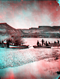 |
Left bank of Green River. Boats of Powell's Second Expedition, before
the start of the journey. The boats are "Cañonita," "Emma
Dean," and "Nellie Powell." Just below the Union Pacific
Railroad bridge at Green River Station. The famous eleven of the Powell
party were Andy Hattan, W. Clement Powell, S. V. Jones, Major John W. Powell,
Frederick S. Dellenbaugh, Professor Almon Harris Thompson, John F. Steward,
F. M. Bishop, Frank C. A. Richardson, Jack Hillers, and E. O. Beaman. Sweetwater
County, Wyoming. 1871. (Photo by E. O. Beaman). |
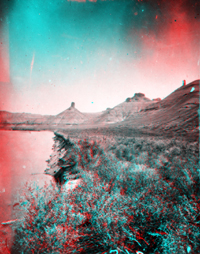 |
Green River, above Flaming Gorge. Sweetwater County, Wyoming. 1871. (Photo by E. O. Beaman). USGS Earth Science Photographic Archive digital file: hjk00510 These bluffs and buttes on the west side of the river are probably near the Firehole Canyon Campground near the "Big Bend" (now Flaming Gorge National Recreation Area). Today, Flaming Gorge Reservoir floods this section of the Green River's floodplain. The nearly flat-lying shale and ledge-forming sandstones (in this and the previous image) are of Late Cretaceous age (Mancos Shale capped by Mesa Verde Group sandstones). |
 |
A fault system runs along the northern flank of the Uinta Mountains that places down-dropped Paleozoic, Cretaceous, and younger sedimentary strata against uplifted ancient metamorphic rocks and sandstone of Precambrian age (ranging in age about 1.0 to 2.3 billion years). These ancient rocks include the Uinta Mountain Group and the older Red Creek Quartzite and form the core of the Uinta Mountains. |
 |
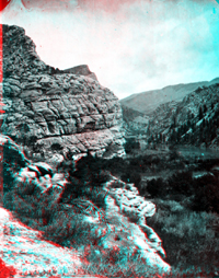
View in Horseshoe Canyon, Utah. 1871 USGS Earth Science Photographic Archive digital file: hjk00655 Horseshoe Canyon is a great U-shaped meander several miles downstream of the "entrance" to Flaming Gorge. At high levels, Flaming Gorge Reservoir turns the inside bend of this canyon into an island. |
 |
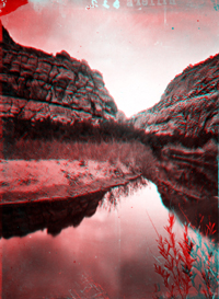
Green River, Horseshoe Canyon, looking upstream. Daggett County, Utah. 1871. USGS Earth Science Photographic Archive digital file: hjk00521 Horseshoe Canyon is flooded by Flaming Gorge Reservoir. |
 |
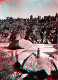
Center of Horseshoe Canyon, Green River. Daggett County, Utah. 1871. USGS Earth Science Photographic Archive digital file: hjk00497 |
 |
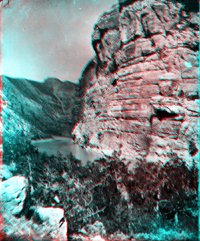
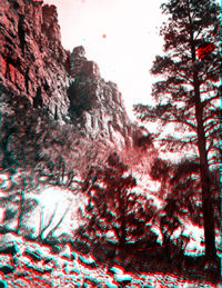
Beehive Point in Kingfisher Canyon. Daggett County, Utah. 1871. USGS Earth Science Photographic Archive digital file: hjk00522 Powell named Kingfisher Canyon after noting the abundance of the birds throughout a section of the canyon between the great bend at Horseshoe Canyon and Beehive Point. Both Powell expeditions (1869 and 1871) camped just upstream of the bend. Kingfisher Canyon is now flooded by Flaming Gorge Reservoir. |
 |
|
 |
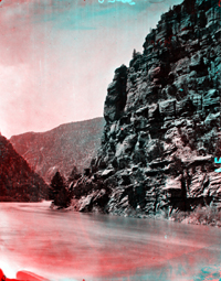
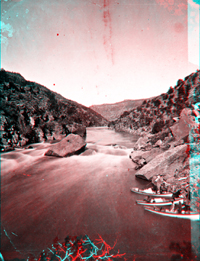
Green River. Red Canyon, one mile below Beehive Point. Daggett County, Utah. 1871. Photo by E. O. Beaman. USGS Earth Science Photographic Archive digital file: hjk00534 ID. Hillers, J. K. 534 |
 |
|
 |
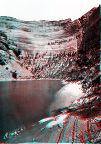
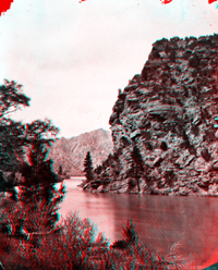
Green River in Red Canyon. Daggett County, Utah. 1871. USGS Earth Science Photographic Archive digital file: hjk00536
The high dam that impounds Flaming Gorge Reservoir was constructed midway through Red Canyon. Construction of the dam began in 1958 and was completed in 1964. Flaming Gorge Dam rises 502 feet above bedrock beneath the impounded river. At capacity, the reservoir extends 91 miles to the north and can hold a volume of 3,788,900 acre-feet. It has a surface area of 42,020 acres (65 square miles). Congress established Flaming Gorge National Recreation Area in 1968. The National Forest Service manages the reservoir and surrounding public land. The recreation area encompasses a total of 207,360 acres (324 square miles), which are almost equally divided between Utah and Wyoming. |
 |
Ashley Falls was the first portage on the voyage. While carrying the boats and materials on the First Expedition, the party found "Ashley, 1825" painted on a rock. William H. Ashley was the man who organized the American fur trade in the Rocky Mountains. Ashley, using a frame boat covered with animal skins, was the first recorded person to navigate the Green River down to this point before retreating upstream. |
 |
Portage of boats. Ashley Falls, Red Canyon, Green River. Daggett County, Utah. 1871. Photo by E. O. Beaman. USGS Earth Science Photographic Archive digital file: hjk00555 |
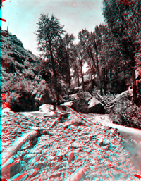 |
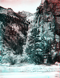
Small side canyon, a tributary to Red Canyon, Green River. Daggett County, Utah. 1871. USGS Earth Science Photographic Archive digital file: hjk00556 |
 |
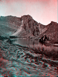
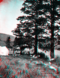
Jack Hillers about halfway up the mountain with two saddle horses, Red Canyon Park. Daggett County, Utah. 1871. USGS Earth Science Photographic Archive digital file: hjk00519 Supplies for the voyage (food rations and equipment) were cached along the route, and homesteads existed in some of the "parks" along the Green River. These horses may have belonged to one of the homesteaders in the canyon or may have been part of a pre-arranged supply party for the Second Expedition. |
 |
|