| Switch to: |
 |
Powell Survey photographers, Jack Hillers and James Fennemore, first visited the Zion Canyon and Kolob Plateau region in the spring of 1872. Hillers returned in April, 1873 to add more photographs to "Virgin River Series" of photographs and stereographs. Hillers described wading the canyon for 4 days and nearly freezing to death from the cold and exposure to take the photography. The photographs below are the stereographs of Hillers' "Virgin River Series" (converted here to anaglyphic views, requiring red-and-cyan glasses to produce a stereographic effect). To see recent 3D photographs of Zion National Park, click here. Zion National Park is situated on an elevated plateau that consists of sedimentary formations of Mesozoic age that dip very gently to the east. The plateau is bounded on the east by the Sevier Fault Zone, and on the west by the Hurricane Fault Zone. Weathering and erosion along north-trending faults and fractures influence the pattern of landscape features associated with canyons in this stream-incised plateau region. |
 |
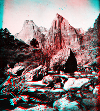
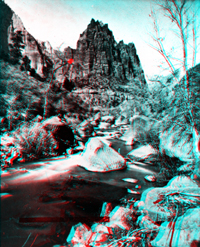
Zion National Park, Utah. The Three Patriarchs on the west side of Zion
Canyon. The Three Patriarchs are visible from the Zion Canyon Visitor Center and Watchman Campground Area. The massive cliffs consist of Lower Jurassic-age formations, including (from bottom to top): the Moenave Formation, the Kayenta Formation, and the massive Navajo Sandstone. These Jurassic-aged cliff-forming formations overlie older slope-forming formations along river level: the Moenkopi Formation (Lower Triassic) and the Chinle Formation (Upper Triassic). The cliffs tops in Zion Canyon range roughly 2,000 feet above stream level. |
 |
The headwaters of the Virgin River bifurcate into several large streams in the vicinity of Zion National Park. The North Fork of the Virgin River is the drainage through Zion Canyon (historically known as the Mukuntuweap Branch). The East Fork flows through Parunuweap Canyon. |
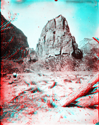 |
Zion National Park, Utah. Temple of Aeolus, Virgin River, west fork (north
fork) in the Mukuntuweap Branch, Little Zion, upper part. USGS Earth Science Photographic Archive digital file:hjk00617 "Temple of Aeolus" is now better known as Angels Landing (elevation 5,990 feet). Today, a fairly strenuous hike to the top of the monolith involves climbing a "chain trail," but the views from the top are some of the most spectacular in the park. Angels Landing is located about a mile north of Zion Lodge on the Zion Canyon Scenic Drive. |
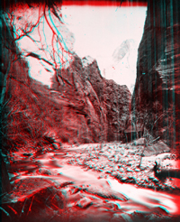 |
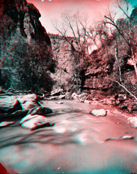
Zion National Park, Utah. Head of the Narrows, North Fork Virgin River. USGS Earth Science Photographic Archive digital file:hjk00646 The Narrows are a section of the river chasm in Zion Canyon about 4 miles upstream from Zion Lodge. |
 |
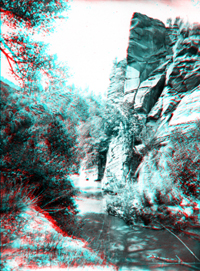
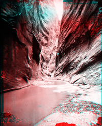
Zion National Park, Utah. Virgin River, west fork in the Mukuntuweap Branch. USGS Earth Science Photographic Archive digital file:hjk00594 Mukuntuweap is the old name for the North Fork of the Virgin River, the main drainage that parallels Zion Canyon Scenic Drive in Zion Canyon. |
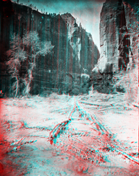 |
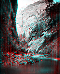
Virgin River, West Fork. Mukuntuweap or Little Zion. Upper end. Utah.
USGS Earth Science Photographic Archive digital file:hjk00609 "Little Zion" may be in the area that is called Pine Creek along the Zion-Mt. Carmel Highway, west of the tunnel. |
 |
Virgin River, Parunuweap Branch (Long Valley Branch), (East Branch). USGS Earth Science Photographic Archive digital files:hjk00532 and hjk0532a The East Fork of the Virgin River drains Parunuweap Canyon in the southeastern section of Zion National Park. |
 |
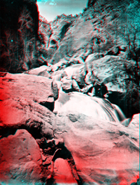
The "Second Rapid" on Virgin River, Parunuweap Branch. Utah. USGS Earth Science Photographic Archive digital file:hjk00541 |
 |
Parunuweap Canyon. East Fork of Virgin River between Long Valley and Shunesburg. Utah. USGS Earth Science Photographic Archive digital file:hjk00553 Shunesburg, Utah is shown as a ranch and cemetery on topographic maps along the East Fork of the Virgin River downstream of Parunuweap Canyon (near the Zion Canyon Visitor Center). |
 |
Virgin River, East Fork (Parunuweap). Utah. USGS Earth Science Photographic Archive digital file:hjk00631 |
 |
Kolob Cliffs or Peaks. Southern Utah. USGS Earth Science Photographic Archive digital file:hjk00706 and hjk0706a This area is now part of the Kolob Canyons area in the northwestern section of Zion National Park. |
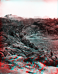 |
Kolob Country. The buttes in the right distance are the great buttes
at entrance of the Mukuntuweap Branch of the Virgin River. Great Temple
Butte (on Virgin River) in the distance. Southern Utah. USGS Earth Science Photographic Archive digital file:hjk00701 "Great Temple Butte" is near the south entrance to the park. This view is looking south probably in the region now known as "Horse Pasture Plateau" in central Zion National Park |
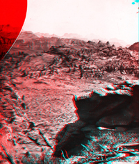 |
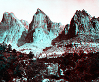
Kolob Country. Buttes of the Mukuntuweap Branch of the Virgin River in
distance. On the horizon is shown the Great Temple, or, as the Mormons call
it, "Steamboat Rock," which is 7500 feet high. Springdale is just
the other side of the square-topped buttes. Southern Utah. (Negative broken). USGS Earth Science Photographic Archive digital file:hjk00712 Springdale is the community just outside the southern park entrance (near the Zion Canyon Visitor Center). The "Great Temple" is labeled "Towers of the Virgin" with a high point, "Altar of Sacrifice" labeled with an elevation of 7,505 feet. |
 |
Zion National Park, Utah. Eagle Crags, Virgin River, west fork in the Mukuntuweap Branch, Little Zion Valley. USGS Earth Science Photographic Archive digital files: hjk00586 and hjk0586a Eagle Crags (elevation 6,394) is along the south side of Virgin Creek downstream of the confluence of the East Fork (Parunuweap) and the North Fork (Mukuntuweap) at Rockville, Utah (located south of the park boundary). |
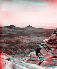 |
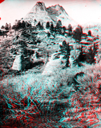
Region south of Toquerville, and south of the Virgin River. Pine Valley
Mountains in the distance. Washington County, Utah. Click here to see recent 3D photography of Zion National Park. |