| Switch to: |
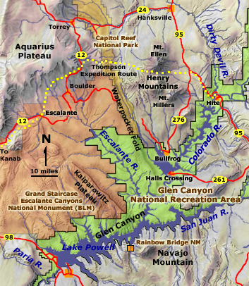 |
On May 30, 1872, "Prof" Almon H. Thompson and members of the Powell Survey party left the Kanab area on a mission to find passage to the mouth of the Dirty Devil River where the Second Expedition crew had stashed a boat, the Cañonita, the previous fall. Other explorers Powell had commissioned the year before had failed to find passage. The route the Thompson Expedition took lead them through the upland valley of the Paria River and skirted the southern end of the Aquarius Plateau. They passed through small Mormon settlements before embarking into the extensive unexplored wilderness that encompassed much of central Utah. They resolved the course of the Escalante River (the last named river in the United States), crossed the Waterpocket Fold (now Capitol Reef National Park), and climbed through a high pass in the Henry Mountains (the last named mountains in the United States). Following canyon drainages south along the eastern flank of the Henry Mountains, they eventually found passage to the mouth of the Dirty Devil River where the party split. Thompson returned west to continue mapping in the Kanab region while four crew members, including photographers, James Fennemore and Jack Hillers, took the cached boat downstream to meet Major Powell and additional survey crew at the mouth of the Paria River to continue the Second Expedition down the Grand Canyon. |
| The photographs below were taken during the Thompson Expedition in 1872 and in 1875 when Jack Hillers returned to take additional photography on the Aquarius Plateau. Powell arranged to have G. K. (Grove Karl) Gilbert investigated the geology of the Henry Mountains in 1875-1876. Dates are noted for photographs where information is available. | |
Click on a small image to open a larger 3D image.
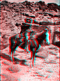 |
Professor Almon Harris Thompson with his horse "Old
Ute." Utah. 1872. USGS Earth Science Photographic Archive digital file: hjk00661 "Prof" Thompson was John Wesley Powell's brother-in-law. Powell appointed Thompson to be in charge of Survey field operations during his absence. |
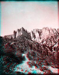 |
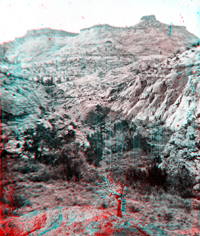
Pink Cliffs. Kane County, Utah. USGS Earth Science Photographic Archive digital file: hjk00624 The Pink Cliffs are an outcrop belt of early Tertiary lake basin deposits along the crest of the Paunsaugunt Plateau. It is likely that the Thompson Expedition passed near the great natural bowl-shaped amphitheater filled with colorful spires, hoodoos, and formations that are now within Bryce National Park. |
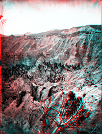 |
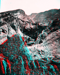
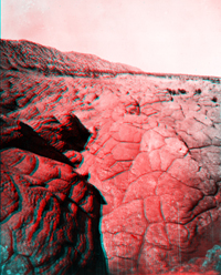
This photograph was probably taken in the vicinity of Henrieville, Utah. Rough canyon country like this exists throughout the Gray and Pink Cliffs regions on the Aquarius Plateau and nearby on the Kaiparowits Plateau. The Gray Cliffs consist of Cretaceous-age shale and sandstone beds deposited in shallow marine and coastal floodplain environments in the era when dinosaurs still existed prior to 65 million years ago. The Pink Cliffs reflect sediments deposited in a great inland lake and marginal floodplains that existed in the region across central Utah through early Tertiary time until about 40 million years ago. |
 |
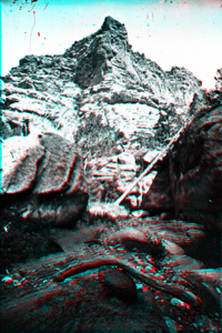
Shinarump Cliff on Escalante River. Utah. USGS Earth Science Photographic Archive digital file: hjk00589 The Shinarump Member is at the base of the Chinle Formation (Triassic). The Shinurump Cliff is also called the "Chocolate Cliffs" in the "Grand Staircase" -- the name for the step-like escarpments sequence produced by Mesozoic- and Tertiary-age sandstone north of the Colorado River in southern Utah and Arizona. |
 |
Escalante Creek, Water Pocket Canyon. Utah. USGS Earth Science Photographic Archive digital file: hjk00670 The "White Cliffs" consist of Navajo Sandstone. The Navajo Sandstone crops out throughout the headwaters of Escalante River region between the towns of Escalante and Boulder, Utah. Today, Utah Highway 12 follows part of the Thompson route through the region. |
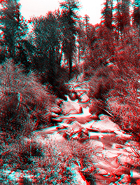 |
Boulder Creek, Aquarius Plateau. Utah. USGS Earth Science Photographic Archive digital file: hjk00786 Boulder Mountain is between Torrey and Boulder, Utah along Highway 12. Elevations exceed 11,000 feet on the highest parts of the plateau that included the late Tertiary age volcanic field that makes up Boulder Mountain. |
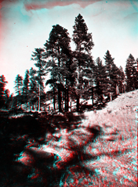 |
Tall trees near Big Boulder Creek, Aquarius Plateau. Utah. USGS Earth Science Photographic Archive digital file: hjk00805 Boulder Creek drains the southern flank of the Aquarius Plateau in the vicinity of Boulder, Utah. It is an upland tributary of the Escalante River. |
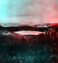 |
Aspen Lake, Aquarius Plateau. Utah. 1872. USGS Earth Science Photographic Archive digital file: hjk00807 "Aspen Lake" does not appear on USGS maps in the Aquarius Plateau, however this is one of many glacial lakes on Boulder Mountain, possibly now named Deer Creek Lake. Hillers traveled through this area in 1872 as a member of the Thompson Expedition, but returned to this high country in 1875 to continue photographing the region. This view is probably facing west, overlooking the headwaters region of the Escalante and Paria rivers in the distance. |
 |
Winslow Creek, a branch of the Escalante River, Aquarius Plateau. Utah. Winslow Creek does not appear on any USGS topographic map of the Aquarius Plateau region. This view is possibly in the region north of the town of Escalante, Utah where a massive fold along the southern Aquarius Plateau exposed a thick sequence of Navajo Sandstone. |
 |
Annus Glen, Winslow Creek. Garfield County, Utah. Annus Glen does not appear on any USGS topographic map in the Aquarius Plateau region. |
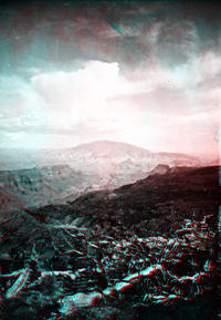 |
Navajo Mountain from Aquarius Plateau. Utah. USGS Earth Science Photographic Archive digital file: hjk00842 It is nearly 80 miles between the southern rim of the Aquarius Plateau and Navajo Mountain (south of Lake Powell). This view was probably taken from a somewhat closer vantage point, perhaps on the Kaiparowits Plateau or on Smoky Mountain in the Escalante Canyons region. |
 |
Temple Creek, a branch of Escalante River, Aquarius Plateau. Utah. USGS Earth Science Photographic Archive digital file: hjk00843 Temple Creek does not appear on any USGS maps of the Aquarius Plateau region. This view is probably in the vicinity of Escalante Utah. |
 |
Temple Creek, Aquarius Plateau. Utah. USGS Earth Science Photographic Archive digital files: hjk00844 and hjk0844a |
 |
"An Obstruction," a boulder lodged between canyon walls, Tantalus
Creek. Utah. USGS Earth Science Photographic Archive digital file: hjk00795 Tantalus Creek is known as "Pleasant Creek" (south of Grand Wash in Capitol Reef National Park). |
 |
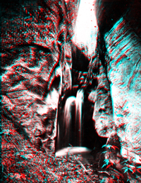
"Minnie's Falls," Tantalus Creek. Utah. USGS Earth Science Photographic Archive digital file: hjk00861 |
 |
Tantalus Creek, mouth of Tantalus Canyon, Aquarius Plateau. Utah. USGS Earth Science Photographic Archive digital file: hjk00859 |
 |
Polygonal weathering. USGS Earth Science Photographic Archive digital file: hjk00676 Parts of the upper Navajo Sandstone display unusual polygonal jointing and weathering. The pattern may reflect expansion from the unloading of overburden as erosion continues to wear away the landscape. Late Tertiary volcanoes blanketed much of the southeastern Aquarius Plateau, but erosion has stripped away this volcanic cover from large parts of the region. Boulders of basalt occur in stream gravels throughout the central Utah region. Note the lack of cross bedding in this massive sandstone unit compared with the detailed bedding of the photograph below. Exposures of polygonal jointing like this also occur along the Burr Trail, east of Boulder, Utah. |
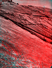 |
On Water Pocket Creek. Turtle-back sandstone. Utah. USGS Earth Science Photographic Archive digital file: hjk00847 Massive cross-bedded layers in the Navajo Sandstone are a testament to the extensive sand dune fields that existed in the Utah region during the Jurassic Period. The dune fields probably rivaled those in the modern Sahara or Arabian deserts in scale. |
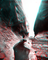 |
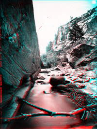
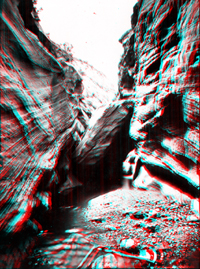
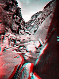
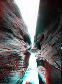
Water Pocket Creek. Utah. USGS Earth Science Photographic Archive digital file: hjk00848 and hjk0848a The Waterpocket Fold runs north-to-south through Capitol Reef National Park in central Utah. Numerous canyons cut through a great hogback ridge of Navajo Sandstone that runs down the fold. The Thompson party probably crossed these canyons midway through the fold (in the vicinity of Notom, Utah) before ascending a pass in the Henry Mountains, named after Powell's friend and supporter, Joseph Henry, director of the Smithsonian Institution. The expedition climbed a pass between two peaks: Mt. Ellen and Mt. Pennell. "Prof" Thompson named Mt. Ellen after his wife, Ellen Powell "Nellie" Thompson; Mt. Pennell was named after Joseph Pennell (an late 19th century American artist/illustrator). He also named a third peak, Mt. Hillers -- after Jack Hillers, the Powell Survey photographer and oarsman. The location of this narrow canyon is in the Waterpocket Fold and is probably along Pleasant Creek (previously named "Tantalus Creek") in Capitol Reef National Park. |
 |
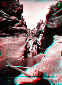
Water Pocket Creek. "A Puzzle." Utah. Click here to see historic photography of the Zion National Park region taken by Jack Hillers and James Fennemore in 1872 and 1873 on expeditions along the canyons of the Virgin River. Click here to see recent 3D photography of the Escalante Canyons area, or click here to see images of Capitol Reef National Park. |