| Switch to: |
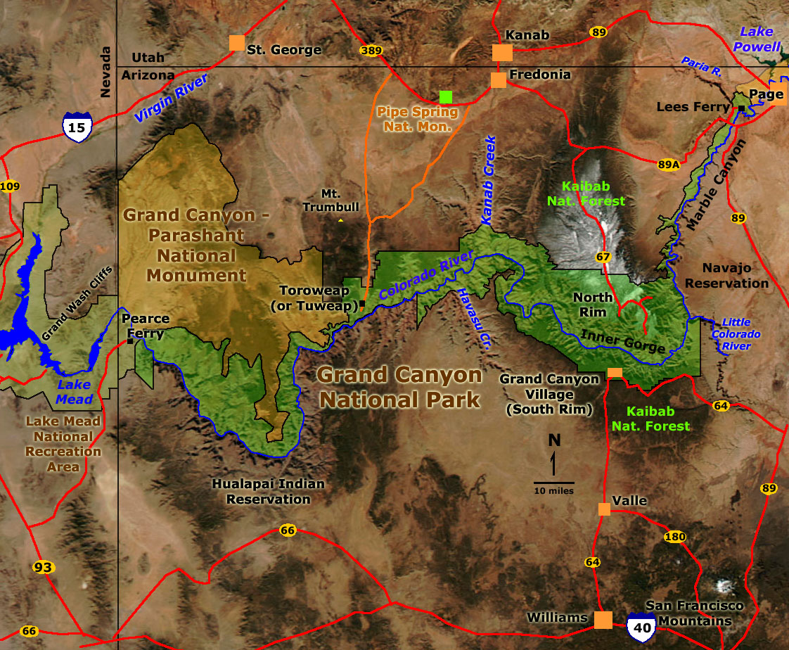 |
|
|
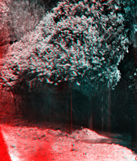
Powell's First Expedition entered Marble Canyon on August 5, 1869. During the next three weeks, Powell's men endured some of the worst hardships of the voyage. Having almost no rations left, and despite the deteriorating condition of their boats, they continued, facing unknown terror in the rapids of the Grand Canyon. The passage through the Inner Gorge severely wore on the men. Upon approaching another section of granite gorge in the lower canyon, three members of the party chose to walk out rather than risk what they considered assured disaster. However, the three members who chose to walk out disappeared, and were reportedly killed by Indians. On August 30th, the six surviving members of the First Expedition passed the Grand Wash Cliffs and met Mormon settlers near mouth of the Virgin River, thus ending the first historic voyage. For the Second Expedition, Major Powell established a temporary survey headquarters in Kanab, Utah where most of expedition party spent the winter (1871 to 1872). Over the winter some members of the party left due to funding problems, boredom, and having other ambitions. In April 1872, photographers Jack Hillers, James Fennemore, and other party members visited Toroweap and other parts of the Grand Canyon's north Rim (Hillers returned to the rim again in January, 1873). On May 25th, 1872, Powell's brother-in-law, "Prof." Almon H. Thompson began an expedition from Kanab to the mouth of the Dirty Devil River. From there, the four-member boat crew of the Cañonita met Powell and other remaining members of the Second Expedition at the mouth of the Paria River in late August. After making repairs to the battered boats (including the Emma Dean and Nellie Powell), the Second Expedition ran Marble Canyon and Grand Canyon (from Lees Ferry to Kanab Wash). Powell decided to end the river expedition on September 9th at Kanab Wash. His decision was based on news that the Shiviwits Indians were threatening to attack the party if they proceeded down the canyon. In addition, Powell's choice was also based on the poor condition of the boats, the exhausted character of his men, and fear of the river that was running with high water. In retrospect, none of the expedition diaries express regret about canceling the river trip below Kanab Wash. The Powell Survey exploration of the Grand Canyon region would continue, but not by river voyage. The photograph collection below includes images from the 1872 river voyage plus images taken by Hillers and Fennemore during overland expeditions in 1872 and 1873. |
|
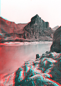 |
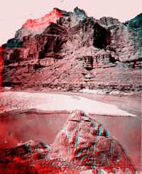
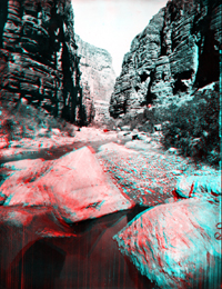
Grand Canyon National Park, Arizona. Marble Canyon. August 1872. USGS Earth Science Photographic Archive digital files: hjk00858 and hjk0858a |
 |
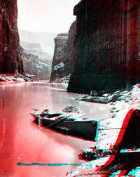
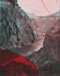
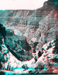
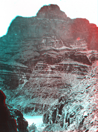
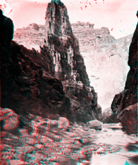
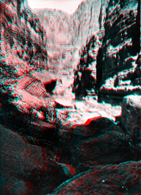
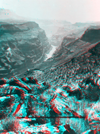
Grand Canyon National Park, Arizona. Marble Canyon. 1872. From Lees Ferry, the Colorado River descends into a canyon lined with Paleozoic-age sedimentary rocks, mostly limestone and dolomite. This motivated Powell to name the river gorge Marble Canyon . Downstream through Marble Canyon rocks of increasing age are exposed at river level. For nearly 50 miles downstream of Lees Ferry, limestone, sandstone, and shale formations of late Paleozoic age (Devonian to Permian in age) crop out in the riverside cliffs. Rocks of each sedimentary formation have unique, recognizable characteristics (including fossils). These formations form the step-like benches in the canyon seen in the distance in this photograph of Marble Canyon. From youngest (top) to oldest (bottom) these included the Kaibab Limestone (highest cliff), Toroweap Formation (slope), Coconino Sandstone (second cliff), Hermit Shale (wide slope), the Supai Group (cliffs and slope above first cliff), and the Redwall Limestone (cliff at river level). |
 |
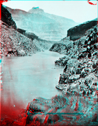
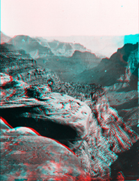
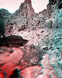
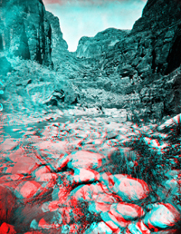
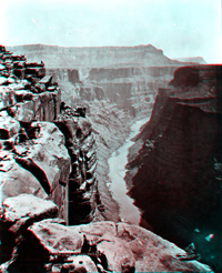
Grand Canyon National Park, Arizona. Marble Canyon. August 1872. USGS Earth Science Photographic Archive digital files: hjk00854 and hjk0854a This view is located above the mouth of Nankoweap Canyon, looking upriver, August 22, 1872. Nankoweap Canyon is located about 52 miles downstream of Lees Ferry. In this view, the Muav Limestone (Cambrian) forms a cliff and slope just above river level. The massive Redwall Limestone (Mississippian) overlies the Muav Limestone. Rocks of Devonian age (Temple Butte and Surprise Canyon formations) occur between the Redwall and Muav formations farther downstream. |
 |
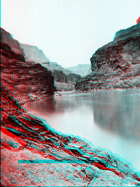
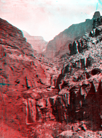
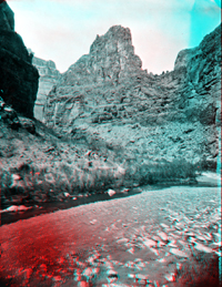
Colorado River. Cliffs opposite the mouth of the Little Colorado River.
Arizona.(Negative broken). USGS Earth Science Photographic Archive digital file: hjk00766 The Little Colorado River enters the Colorado River just beyond 61 miles downstream of Lees Ferry. |
 |
|
 |
Grand Canyon National Park, Arizona. Grand Canyon, looking up the river,
just below the mouth of the Little Colorado River. August 1872. USGS Earth Science Photographic Archive digital files: hjk00863 and hjk0863a |
 |
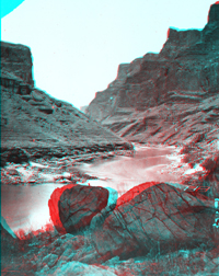
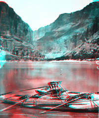
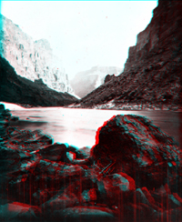
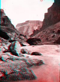
Grand Canyon National Park, Arizona. Boats near the mouth of the Little
Colorado River. 1872. USGS Earth Science Photographic Archive digital files: hjk00885 and hjk0885a These photographs of the Second Powell Expedition boats were taken in the vicinity of the Little Colorado River mouth. |
 |
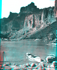
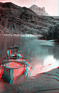
Two boats in Marble Canyon, Colorado River. Major Powell's armchair in
on one of the boats. Grand Canyon National Park. Coconino County, Arizona.
1872. USGS Earth Science Photographic Archive digital file: hjk00850 |
 |
Grand Canyon National Park, Arizona. Major Powell's famous armchair boat
on the Colorado River. August 22, 1872. USGS Earth Science Photographic Archive digital file: hjk00856 |
 |
Major Powell's boat with famous armchair. Grand Canyon, Colorado River.
Arizona. Negative cracked. USGS Earth Science Photographic Archive digital file: hjk00605 |
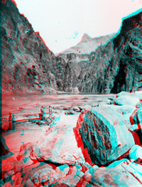 |
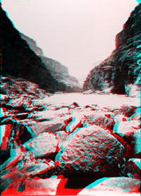
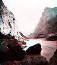
Grand Canyon National Park, Arizona. Repairing a boat at First Granite
Gorge. September 1872. USGS Earth Science Photographic Archive digital files: hjk0871a and hjk0871b Powell didn't note seeing granite in the Inner Gorge until September 23, 1869. This photograph resembles published views in the Grand Canyon's Inner Gorge near Mile 82 (miles below Lees Ferry) in the vicinity of Grapevine Rapid (about 5 miles upstream from Phantom Ranch on Bright Angel Creek). The dark Precambrian granitic and metamorphic rocks stand out in contrast to the lighter-colored sedimentary rocks higher on the canyon walls. In the distance down the gorge, a flat-lying, ledge-forming unit is the Tapeats Sandstone that rests directly on the "Great Unconformity". The great unconformity is a boundary between the ancient eroded surface on the crystalline rocks that formed nearly 1.8 billion years old, and sediments deposited on top (The Tapeats Sandstone) which were deposited in shallow seas during the Cambrian Period, about 560 million years ago. |
 |
Grand Canyon National Park, Arizona. First Granite Gorge. September 1872.
Negative cracked. USGS Earth Science Photographic Archive digital file: hjk00872 |
 |
Grand Canyon National Park, Arizona. Granite of the first gorge. September
1872. USGS Earth Science Photographic Archive digital file: hjk00875 |
 |
Grand Canyon National Park, Arizona. Andy Hattan by the boats. 1872.
USGS Earth Science Photographic Archive digital file: hjk00886 |
 |
Grand Canyon National Park, Arizona. Muav Canyon. USGS Earth Science Photographic Archive digital files: hjk00899 and hjk0899a Jack Hillers continued to photograph in Grand Canyon region in the years following the river expeditions of 1871-1872. This view of Muav Canyon was probably taken during a trip to the canyon rim in 1873. |
 |
Grand Canyon National Park, Arizona. Muav side canyon. USGS Earth Science Photographic Archive digital files: hjk00901 and hjk0901a This Jack Hiller's photograph of Muav Canyon was probably taken in 1873 during a return trip to the canyon's north rim. |
 |
Grand Canyon National Park, Arizona. Grand Canyon near Toroweap (or Muav).
USGS Earth Science Photographic Archive digital files: hjk00902 and hjk0902a This Jack Hiller's photograph of Muav Canyon was probably taken in 1873 during a return trip to the canyon's north rim. |
 |
Grand Canyon National Park, Arizona. Tapeats Creek. September 1872. Negative
cracked. USGS Earth Science Photographic Archive digital file: hjk00892 Tapeats Creek drains the North Rim and is located just over 134 miles downstream from Lees Ferry. |
 |
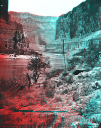
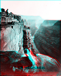
Grand Canyon National Park, Arizona. Outlet of Surprise Valley 10 miles
above the mouth of Kanab. September 7, 1872. This photo is of Deer Creek Falls about 2 miles downstream from Tapeats Creek. Powell passed the falls after dinner on August 23, 1869. In his river journal he wrote, "Just after dinner we pass a stream on the right which leaps into the Colorado by a direct fall of more than 100 feet. On the rocks in the cave-like chamber are ferns, with delicate fronds and enameled stocks." This photograph was taken during the Second Expedition, the last day on the river for the Second Expedition. |
 |
Grand Canyon National Park, Arizona. Just above the mouth of Kanab Canyon.
September 1872. USGS Earth Science Photographic Archive digital files: hjk00891 and hjk0891a The Powell Expedition stopped at Kanab Creek on September 7th. Kanab Creek drains into the Colorado from the north just over 143 miles downstream from Lees Ferry. Considering river conditions, the condition of the crew, worries of Indian troubles, and lack of supplies, Powell chose to end the river expedition and continue overland. The boats were abandoned at the river. Jack Hillers and Clem Powell would stick behind a couple days taking photographs of lower Kanab Canyon before heading north to join the others at Kanab, Utah. |
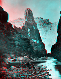 |
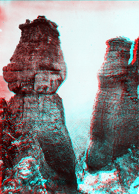
Grand Canyon National Park, Arizona. Marble Pinnacle in Kanab Canyon.
USGS Earth Science Photographic Archive digital files: hjk0071a and hjk0071b The Marble Pinnacle in Kanab Canyon is nearly 2,000 feet high. |
 |
Kanab Canyon, near mouth. Cliffs in the distance right and left are on
the other side of the Colorado River. The boats are the Powell boats of
the Second Expedition. 1872. "The water in 1872 was so high that it
backed up this side canyon and the boats were rowed up to this position
to find a quiet place away from the current of the river." Frederick
S. Dellenbaugh. USGS Earth Science Photographic Archive digital file: hjk00692 |
 |
Kanab Canyon, near Pinnacle (from downstream). Arizona. USGS Earth Science Photographic Archive digital file: hjk00622 |
 |
Showerbath Spring in Kanab Canyon. Three or four miles above junction
with Grand Canyon. Arizona. USGS Earth Science Photographic Archive digital file: hjk00625 |
 |
The Pinnacle in Kanab Canyon. Looking down the canyon. Arizona. USGS Earth Science Photographic Archive digital file: hjk00629 |
 |
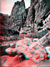
Kanab Canyon, near Pinnacle, looking up the canyon. This view was taken
around the bend below Hillers Photo #629. Arizona. USGS Earth Science Photographic Archive digital file: hjk00632 |
 |
Kanab Canyon, near Pinnacle, looking up the canyon. This view was taken
around the bend below Hillers #629. Arizona. USGS Earth Science Photographic Archive digital file: hjk00634 |
 |
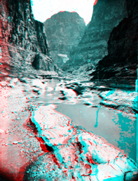
Kanab Canyon. Arizona USGS Earth Science Photographic Archive digital file: hjk00638 |
 |
Kanab Canyon. Arizona USGS Earth Science Photographic Archive digital file: hjk00644 |
 |
Kanab Canyon. Arizona USGS Earth Science Photographic Archive digital file: hjk00647 |
 |
Kanab Canyon. Arizona USGS Earth Science Photographic Archive digital file: hjk00667 |
 |
Kanab Canyon. Arizona USGS Earth Science Photographic Archive digital file: hjk00685 |
 |
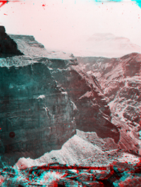
Grand Canyon National Park, Arizona. Grand Canyon of the Colorado River at the foot of the Toroweap. USGS Earth Science Photographic Archive digital file: hjk00066 Toroweap is located on the North Rim of the Grand Canyon about 70 miles southwest of Kanab, Utah. Jack Hillers came here first with James Fennemore in January 1872, then returned again in 1874 to take more photographs of this section of the canyon. Cliffs at Toroweap are nearly 3,000 feet high and provide an overlook of Lava Falls (located at mile 179 in the Grand Canyon). Today, a long dirt road leads to a remote campground at the canyon edge at Toroweap. |
 |
Colorado River. Grand Canyon, near foot of Toroweap, looking east. Arizona. USGS Earth Science Photographic Archive digital file: hjk00511 Note the human for scale. This view is accessible at the Toroweap Campground. |
 |
Grand Canyon National Park, Arizona. Across the south foot of Toroweap.
USGS Earth Science Photographic Archive digital file: hjk00896 These massive cliffs of Redwall Limestone (Mississippian) are across the canyon from Toroweap overlook. |
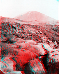 |
Grand Canyon National Park, Arizona. The Cinder Cone near the foot of
Toroweap. USGS Earth Science Photographic Archive digital file: hjk00905 Vulcans Throne (elevation 5,102 feet) is a volcano of Quaternary age on the North Rim of the Grand Canyon just south of Toroweap. Vulcans Throne and other volcanoes along this section of the canyon produced lava flows that poured into the canyon many times in the past. Some of these event created natural dams that intermittently created natural great lakes in the canyon. Between volcanic eruptions and flows the river erosion would reclaim the canyon. This photograph shows one of the lava flows from Vulcans Throne near the edge of the canyon. Lava Falls (about 2 miles downstream from Toroweap) is a rapid that runs over remnants of ancient lava flows that flooded the canyon. Most of the volcanoes occur along the trace of the Toroweap Fault, a north-to-south-trending fault that crosses the canyon just west of the Toroweap overlook area. |
 |
Grand Canyon National Park, Arizona. West from the foot of Toroweap. USGS Earth Science Photographic Archive digital files: hjk00897 and hjk0897a This view is looking downstream from the southern end of the Toroweap overlook area. The slope in the foreground is partially covered with lava flows from the Vulcans Throne volcanic area that poured into the canyon. Further downstream another 20 miles, the canyon re-enters another granite gorge. |
 |
Grand Canyon, Colorado River, near Lava Falls. Arizona. USGS Earth Science Photographic Archive digital file: hjk00598 A trail from Toroweap Campground extends down to river level at Lava Falls. With an elevation drop of almost 3,000 feet from the rim, this traverse must have been extremely difficult to transport the heavy cameras and other equipment needed to photograph the river. |
 |
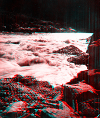
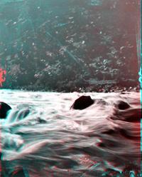
Lava Falls, Colorado River, Grand Canyon. Arizona. Shows only a part
of falls. USGS Earth Science Photographic Archive digital file: hjk00616 Lava Falls is one of the most treacherous rapids in the canyon, having a drop of 13 feet in about a quarter mile passage. |
 |
Lava Falls, under Toroweap, Colorado River. Arizona. USGS Earth Science Photographic Archive digital file: hjk00693 |
 |
Lava Falls, Colorado River, Grand Canyon. Arizona. USGS Earth Science Photographic Archive digital file: hjk00627 |
 |
Lava Falls, Colorado River, Grand Canyon. Arizona. USGS Earth Science Photographic Archive digital file: hjk00618 James Fennemore photographed this view of the rapid at Lava Falls on April 19 or 20, 1872. Jack Hillers returned in January and February 1873 to take more photographs in the Mt. Trumbull and Toroweap area. |
 |
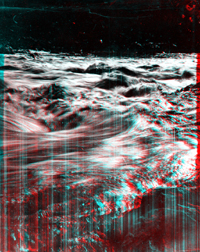
Dangerous water of Lava Falls, Colorado River, Grand Canyon.
Arizona. USGS Earth Science Photographic Archive digital files: hjk00623 and hjk0623a |
 |
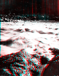
Rough water Lava Falls, Colorado River, Grand Canyon. Arizona. Shows
only a part of falls. USGS Earth Science Photographic Archive digital file: hjk00615 |
 |
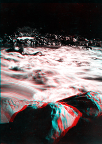
Colorado River, Grand Canyon, below Lava Falls which is seen in the middle distance. Arizona. USGS Earth Science Photographic Archive digital file: hjk00602 Click here to continue to photography of the 1872 Thompson Expedition to find the mouth of the Dirty Devil River. Click here to continue to Jack Hiller's stereo photography of the Virgin River canyons (now Zion National Park). Click here to see modern photography of Grand Canyon National Park. |