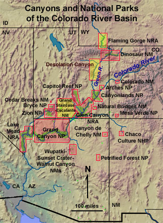
Park Stratigraphy of the Colorado Plateau

Map of the Colorado River Basin


Alphabetical list of rock units in the region
Rock units listed by geologic age

Click on the map or list below.
Arches National Park
Bryce Canyon National Park
Canyonlands National Park
Capitol Reef National Park
Canyon de Chelly National Monument
Cedar Breaks National Monument
Chaco Culture National Historic Park
Colorado National Monument
Desolation Canyon and Gray Canyon
Dinosaur National Monument
Flaming Gorge and Red Canyon
Glen Canyon National Recreation Area
Grand Canyon National Park
Grand Staircase - Escalante Canyons National Monument
Lake Mead National Recreation Area
Mesa Verde National Park
Natural Bridges National Monument
Petrified Forest National Park
Wupatki-Sunset Crater Volcano-Walnut Canyon National Monuments

Zion National Park

This website is a guide to rock formations exposed in selected national parks and natural areas on the Colorado Plateau.

Linked web pages with generalized stratigraphic sections are intended as reference for selected park websites included in the "3D Geology of National Parks" website: https://gotbooks.miracosta.edu/gonp/. The 3D Geology of National Parks website contains photographic tours of selected park areas in both 3D-images and standard photographs (both modern and historic imagery).

Click here to see current Geologic Time Scale information.

For a general summary of the geology of the Colorado Plateau, see a summary by Annabelle Foos (1999) on the NPS website: http://www.nature.nps.gov/geology/education/foos/plateau.pdf


Click here to see a series of thematic maps about the Southern Colorado Plateau Region.
Important information about this website:

Subsurface geologic information is not included on individual stratigraphic sections, but can be inferred from surrounding areas (such as in the Grand Canyon and Flaming Gorge areas where the Colorado and Green rivers carved canyons that exposed ancient bedrock). Stratigraphic sections show the relative thickness and age of named geologic units. Each of the named units on each stratigraphic sections is hot-linked to information derived (and revised) from the USGS GeoLex (Lexicon of Geology): http://ngmdb.usgs.gov/Geolex/ - and from other sources. Lexicon data provides a snapshot of the age and extent of rock units, plus reference sources that provide insight into the historic exploration, discovery, and ongoing research into Earth history and natural resources associated with each unit. Note that possibly many other stratigraphic names may exist in the literature that may not appear in the Geolex Database or within this website. Also note that the USGS and other geologic agencies try to use uniform usage of unit names, but not all terminology is uniformly used or currently accepted by every organization. Each of the stratigraphic sections (and linked named units) use terminology from the most recently published stratigraphic sections based of references listed on individual pages, most of which where initially compiled in 2004. More recent reviews, discoveries, or changes in stratigraphic nomenclature may exist in the literature.

For more source information about regional stratigraphy that may not appear on this website see Stamm, N. and Soller, D., [2008], Geolex Database [a subset of the National Geologic Map Database]: Reston, Virginia: U.S. Geological Survey. Available online at http://ngmdb.usgs.gov.
This page is <https://gotbooks.miracosta.edu/gonp/coloradoplateau/>
Last modified: 8/18/2010

Mesa Verde Petrified Forest Grand Canyon Lake Mead Zion Bryce Canyon Grand Staircase - Flaming Gorge Glen Canyon Dinosaur Capitol Reef Desolation and Gray Canyons Canyonlands Arches Colorado Chaco Canyon Canyon de Chelly Wupatki-Sunset Crater-Walnut Canyon Natural Bridges Cedar Breaks