|
See geology photo tours of Sunset Crater, Walnut Canyon, and Wupatki National Monuments.
| Sunset Crater, Wupatki, and Walnut Canyon national monuments are all in the vicinity of Flagstaff, Arizona. The pueblo ruins at Wupatki National Monument were constructed around 1100 AD and were abandoned about a century later. The volcanic eruption of Sunset Volcano in about 1000 AD had blanketed the region with a thin layer of cinders that helps retain soil moisture for agriculture. At its prime the pueblo was probably home to about 100 people. |  |
| Sunset Crater is one of the youngest volcanoes in the San Francisco Peaks volcanic field. The cinder cone formed from an eruption around 1000 AD and was no doubt witnessed by the native population that was living in the region at the time. To learn more about Sunset Crater National Monument check out the National Park Service website at: http://www.nps.gov/sucr/. | 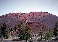 |
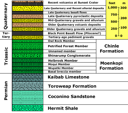
| The gentle relief of the generally barren landscape in and around Wupatki National Monument is a reflection of the soft, eroding mudrock and shale of the Chinle Formation (Triassic). To learn more about Wupatki National Monument check out the National Park Service website at: http://www.nps.gov/wupa/. | 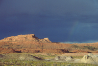 |
| Walnut Canyon is carved into the same rock formation exposed along the rim of the Grand Canyon: The Kaibab Limestone, Toroweap Formation, and Coconino Sandstone (youngest to oldest respectively). The Sinagua Indians built small stone cliff dwellings in overhangs of the Kaibab Limestone in Walnut Canyon from about 1100 to 1250. To learn more about Walnut Canyon National Monument check of the National Park Service website at: http://www.nps.gov/waca/. | 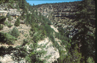 |
Source: NPS park map & guides for Sunset Crater, Wupatki, and Walnut Canyon National Monuments. |
|
|
Stratigraphy after: Haines, D. V., and Bowles, C. G., 1976, Preliminary geologic map and sections of the Wupatki NE Quadrangle, Coconino County, Arizona: U.S. Geological Survey Open-File Report 76-703, 18 p; map scale 1:24,000. Stratigraphic unit information is modified from the USGS GeoLex (Lexicon of Geology): http://ngmdb.usgs.gov/Geolex/geolex_qs.html. Information about the Geologic Time Scale is available at: https://gotbooks.miracosta.edu/gonp/coloradoplateau/timescale.htm. |