| |
 |
Click here
to see a collection of historic images of what is now Dinosaur National
Monument taken by the Powell Expedition of 1872. Website images include
both standard photograph and 3D views (as anaglyphs - requiring
red-and-cyan 3D viewing glasses). This view show part of the Canyon of Lodore where rocks of the Uinta Mountain Group crop out along the Green River in Dinosaur National Monument. To learn more about Dinosaur National Monument, check out the National Park Service website at: http://www.nps.gov/dino. |
|
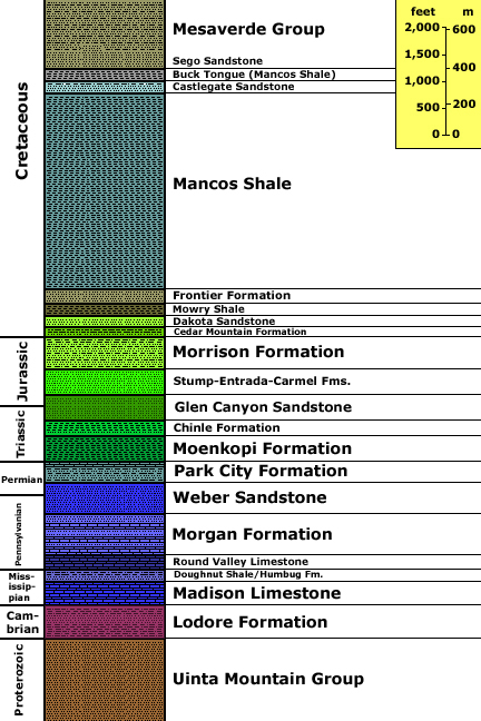
Generalized stratigraphy after Gregson, J. D. and Chure, D. J., 2000, Geology and Paleontology of Dinosaur National Monument, Utah-Colorado: In Geology of Utah's Parks and Monuments, Sprinkel, D.A., Chidsey, T. C., and Anderson, P. B., editors, Utah Geological Association Publication 28., p. 155-188. Stratigraphic unit information is modified from the USGS GeoLex (Lexicon of Geology): http://ngmdb.usgs.gov/Geolex/geolex_qs.html. Information about the Geologic Time Scale is available at: https://gotbooks.miracosta.edu/gonp/coloradoplateau/timescale.htm. |