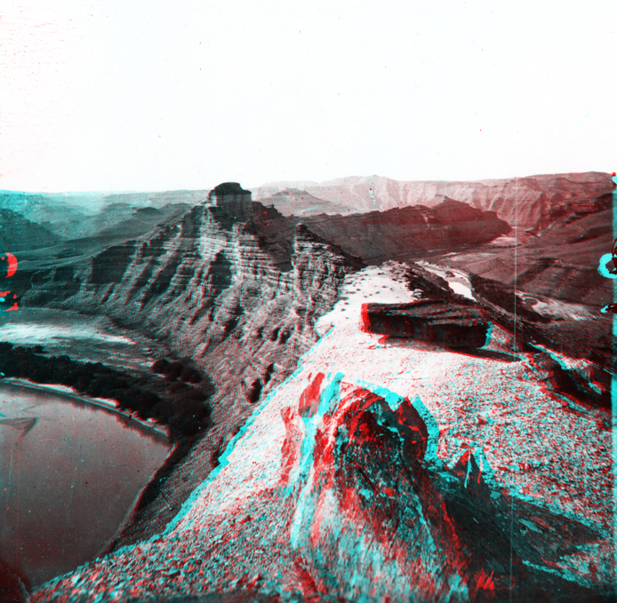
Bowknot Bend, Labyrinth Canyon. Utah.
USGS Earth Science Photographic Archive digital file: hjk00708
E. O. Beaman took this photograph from the west end of the narrow saddle of Bowknot Bend (located about 48 miles downstream of "Gunnison Crossing" at Green River State Park, Utah). Only 1,200 feet separates the river channel, even though the path of the river channel continues 7.5 miles in a circular loop. The saddle is along the crest of a gentle structural upwarp called the Cane Creek Anticline. This region is part of the Paradox Basin, an older structural basin that formed along the western side of the Ancestral Rocky Mountains in Pennsylvanian and Permian time (much earlier that the uplift and subsidence that occurred during and following the Laramide Orogeny that formed the Uinta Basin and modern Rocky Mountains that we see today). Massive deposits of salt and gypsum occur deep in the subsurface here; flowing salt under pressure forms many of the structures in the region (a process that is still occurring). Cliffs along the river consist of Triassic-age Moenkopi Formation capped by Chinle Formation. In the distance sheer cliffs roughly 300 feet high consist of Wingate Sandstone capped by Kayenta Formation, both of Late Triassic age.