|
Geology and Natural History of San Pasqual Valley |
|
Old Coach Trail, Raptor Ridge Trail, Mule Hill Trail, and Highland Valley Trail |
A1
| The San Pasqual Valley is located east of Interstate 15 between Rancho Bernardo and Escondido, California. The valley are is host to several trails associated with the Coast To Crest Trail system within the San Dieguito River Parks, Figures 1 and 2 are maps that show the location the trails, parks, and landscape features. |
|
Mule Hill Trail - This trail connects with the Lake Hodges trail system at Sikes Adobe (a restored historic farmstead located at 12655 Sunset Dr. Escondido, CA). The trail follows the north side of the valley through the Mule Hill Historic Battlefield area, past agricultural fields, and then crosses wetlands along the San Dieguito before intersecting the Raptor Ridge and Old Coach Trails. |
Raptor Ridge and San Pasqual Valley Trail - This trail begins at the Old Coach Staging Area (a parking lot on Highland Valley Road) near where it connects with the east end of the Mule Hill Trail. This trail follows the south side of San Pasqual Valley and climbs to a couple overlooks on the side of the mountainside called Raptor Ridge. The trail continues eastward following a route leading eastward to the eastern end of the valley. |
| Old Coach Trail - The Old Coach Trail follows the historic Butterfield Stage route south, a fairly steep route up and over a divide on the mountainous ridge and continues southward connecting to trails in the Poway Area. This route include a walk to the top of "Water Tank Peak" to view the regional landscape. |
| Highland Valley Trail - This trail starts at a trailhead parking area near the intersection of Pomerado Road and Highland Valley Road near I-15. The trail runs through a wildlife corridor area on the slope along south side of San Pasqual Valley and the lower valley of Sycamore Creek Canyon. |
| San Diego Zoo Safari Park - The San Diego Zoo Safari Park is a wildlife sanctuary maintained by the San Diego Zoo Wildlife Alliance. The park entrance is located at 15500 San Pasqual Valley Road, Escondido, California 92027. The SD Zoo Safari Park host to wild and endangered animals in free-range enclosures throughout 1,800 acres on the north side of San Pasqual Valley. |
| Kit Carson Park - This City of Escondido park has 100 acres of park recreational facilities and preserves 185 acres of natural habitat in the Bear Creak Valley. The park is located at 3333 Bear Valley Parkway, Escondido, CA 92025. The park is home to Niki de Sait Phalle's Queen Califia's Magic Circle (sculpture garden).The park is named after Christopher (Kit) Carson, a scout who guided Captain John C. Frémont's 1844 exploration expedition through the Rocky Mountains, Sierra Mountains, and California. Kit Carson was a member of the US troopers who fought in the battle in San Pasqual Valley in 1846. |
A2
Click on images for a larger view. |
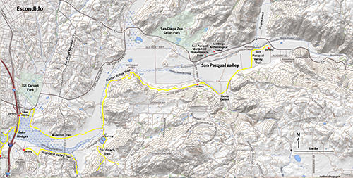
Fig. 1. Topographic map of the San Pasqual Valley south of Escondido, CA, |
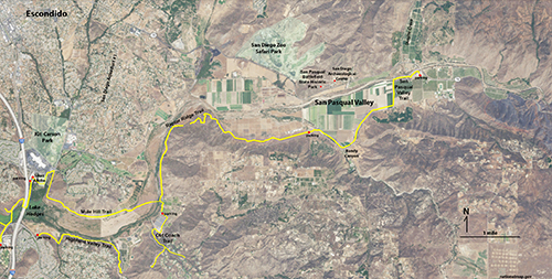
Fig. 2. Satellite map with trails in the San Pasqual Valley. |
A3
Historic USGS Topographic Maps From 1901 ans 1903
Figure 3 shows historic maps of the San Dieguito River valley and Del Dios Gorge before Lake Hodges Dam was constructed in 1918. The part of USGS Escondido 1:64,500 quadrangle map from 1901 is on the left, and part of the Ramona 1:000,000 scale map from 1903 is on the right.
The old Inland Highway route crossed the "Bernardo River" (historic name for the San Dieguito River) near Mule Hill. A wooden bridge across the river was washed out in a flooding of 1916-17. A new cement bridge was completed in 1919. To make way for the reservoir, the town of Bernardo was torn down and dismantled prior to the filling of Lake Hodges Reservoir. US Highway 395 was established in 1935. In 1955, the historic Highway 395 bridge was constructed to replace the older, narrow bridge. In 1981, it was widened to become part of the Interstate 15 system. Those bridges were replace yet again in 2008 to support the more expansive modern interstate 15.
The map also includes the old Butterfield Stagecoach route (in the vicinity of the Old Coach Trail between Poway and Escondido). Stage coaches began carrying mail, money and passengers in the San Diego region in 1852 but stage coach era ended in 1882 when the coastal railroad system was completed. The city of Escondido was incorporated in 1888. |
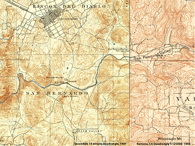
Fig. 3. Historic U.S. Geological Survey topographic maps from 1901 and 1903 of the San Pasqual Valley and San Dieguito River Gorge south of Escondido and north of the San Bernardo and Poway areas, CA. |
A4
Geology and Physiography of the San Pasqual Valley Area
This relatively broad upland valley where several stream tributaries merge within the San Dieguito River watershed. Two principle streams include Santa Ysabel Creek, which drains into the valley from the west via Clevenger Canyon from the headwaters region around Vulcan Mountain near Julian, and Santa Maria Creek drains into the valley from Bandy Canyon from the headwaters region surrounding the upland around Ramona.
Nearly all the bedrock exposed in the hills and mountainsides around San Pasqual Valley consist of granitic rocks (labeled gr on the geologic map, Figure 4). These rocks are part of the Western Peninsular Ranges Batholith, a region underlain by crystalline basement rock of intrusive igneous origin. They represent rocks that crystallized in massive igneous plutons associated with an ancient volcanic arc system that developed in the region during the Mesozoic Era. Most of the granitic rocks are of Cretaceous age. Rock of Jurassic and older ages are locally preserved in small areas (one area is labeled as pKm on the geologic map).
|
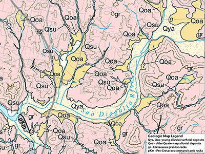
Fig. 4. Geologic map of the San Pasqual Valley. |
A5
Granitic Rocks (gr) - Intrusive Igneous Rocks of Cretaceous Age
Granitic rocks (gr on the map) dominate the bedrock throughout the San Pasqual Valley area. The rocks formed where subduction zone magmas rose and and crystallized, forming the plutonic bodies that make up the western part of Peninsular Ranges batholith (Figure 5). The bedrock consists of igneous plutons that have been assigned names including Woodson Mountain granodiorite, Green Valley tonalite, and Bonsall tonalite (by Larsen, 1948). Figures 6 to 13 are examples of granitic rocks in the San Pasqual Valley area. Geologic ages determined from granitic rock samples collected across the region (using Rb-Sr absolute dating methods) suggest that they formed in a volcanic arc and associated plutons existed in the region about 125 Ma to 105 million years ago (early Cretaceous age; Kistler and others, 2003). Widespread igneous activity in the Peninsular Ranges ended with the changes in the plate-tectonic setting of western North America. By 100 to 90 million years ago, subduction and volcanism had ended in the Southern California region and had moved gradually farther inland beneath what is now the Rocky Mountains region. |
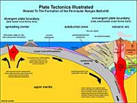
Fig. 5. Plate tectonics model with a volcanic arc and batholith forming above a subduction zone.
|
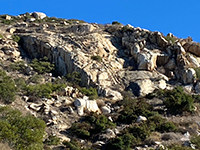
Fig. 6. Granitic bedrock exposed on Raptor Ridge. |
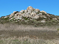
Fig. 7. Granitic bedrock and boulders at Mule Hill. |
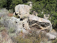
Fig. 8. Granitic rocks along with dikes and inclusions.
|

Fig. 9. Granite outcrop with a weathering surface patina. |

Fig. 10. Tonalite (feldspars, quartz, and mafic minerals). |

Fig. 11. Gabbro (feldspars, mafic minerals, little quartz). |
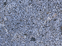
Fig. 12. Tonalite with dark gabbro inclusions. |

Fig. 13.Tonalite boulder with dark gabbro inclusions. |
|
A6
Geologic History After the Subduction-Zone-Related Volcanism Ended
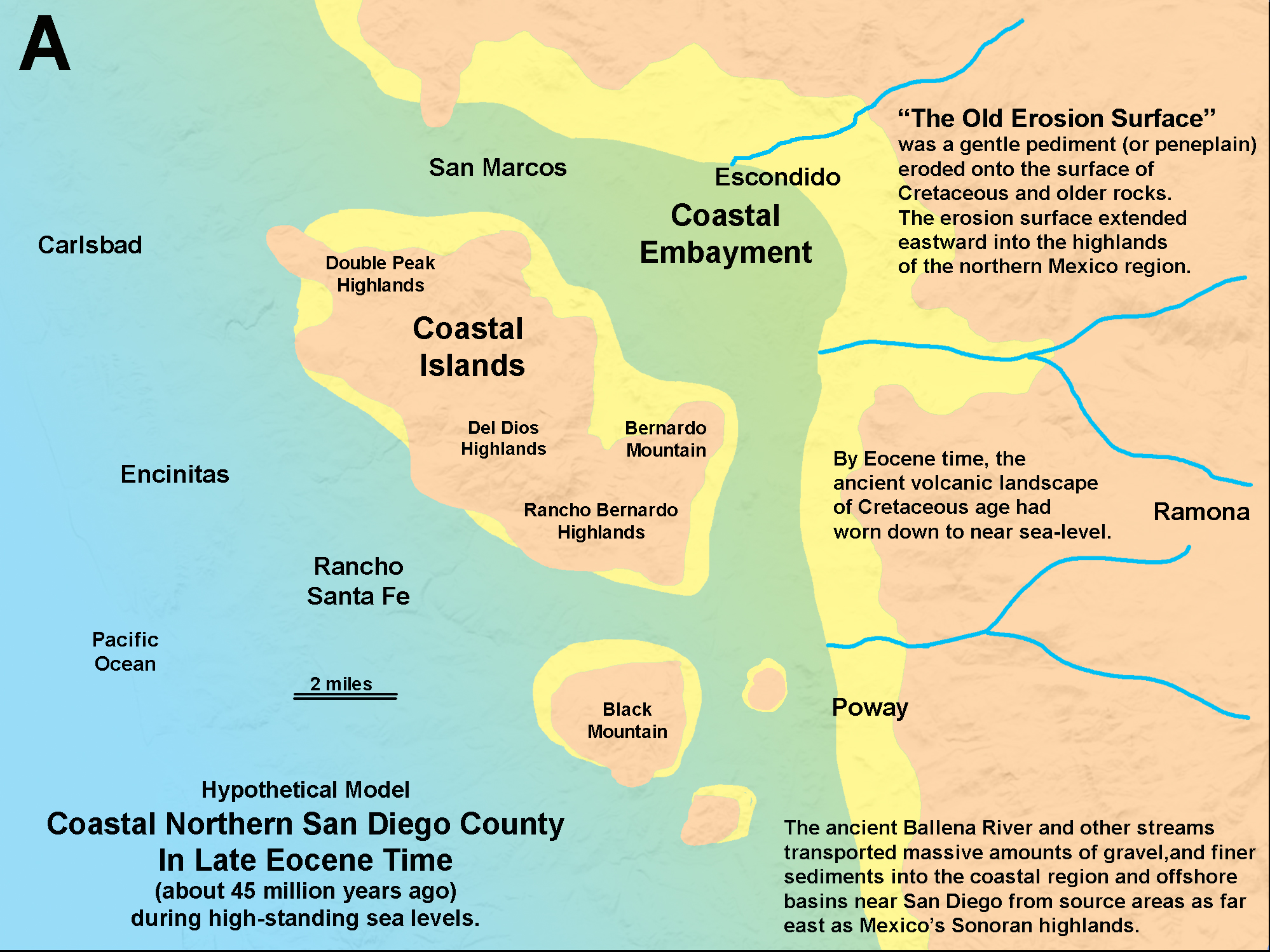
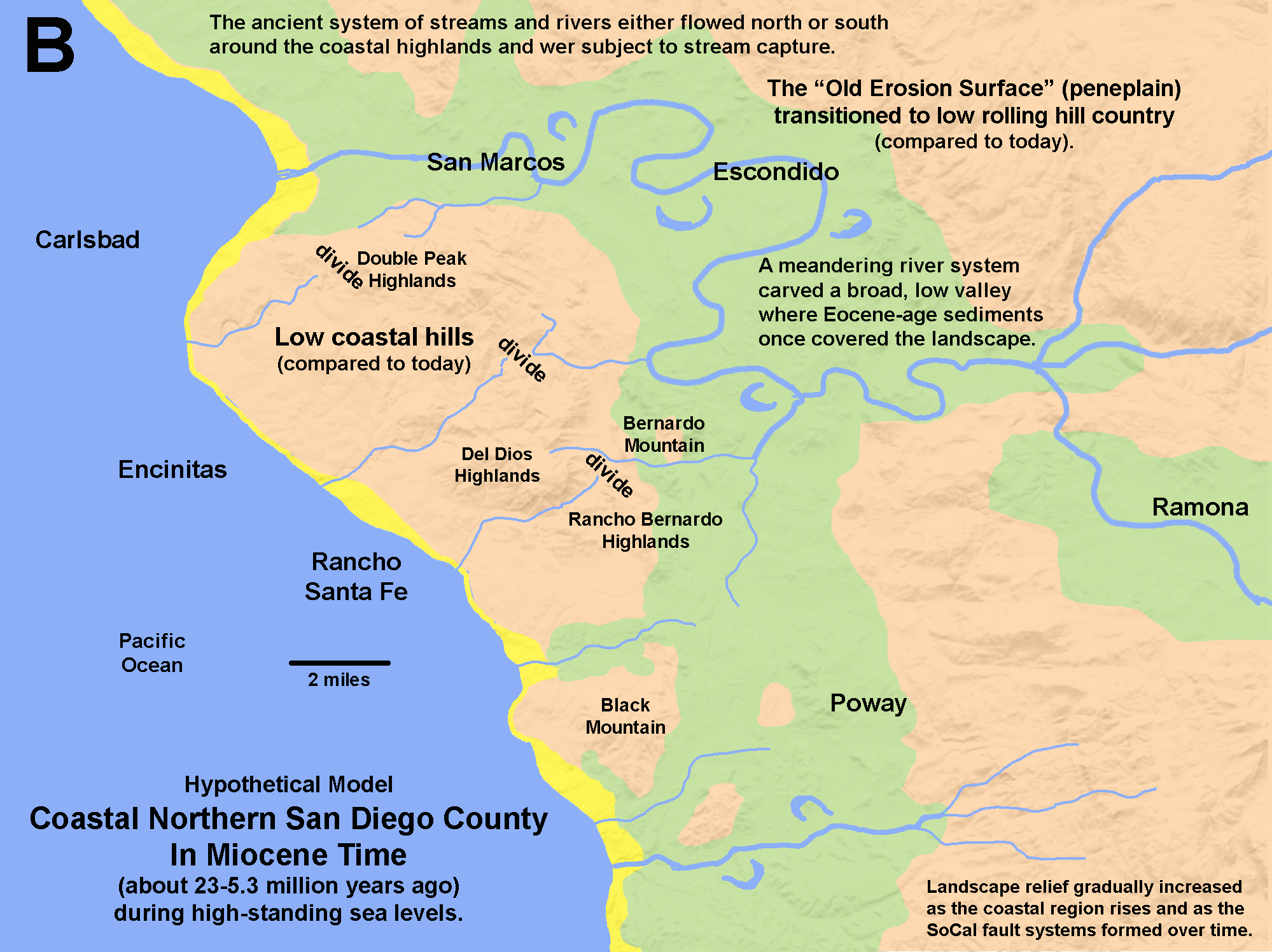
The four diagrams below illustrate how the coastal San Diego regional geology may have evolved over time. Figure 14 is a regional geologic map that includes a landscape profile line used in the hypothetical cross-sections for different time periods over time (Figures 15 to 17). The ancient volcanic landscape that accompanied the massive igneous plutons of the Peninsular Ranges batholith formed in Early Cretaceous time, ending about 100 to 90 million years ago. Over the next 50 to 60 million years, the landscape wore down to a broad regional peneplain that transitioned to coastal continental shelf (when sea levels were high). Meanwhile, coastal erosion carved away at the shoreline, gradually moving the coastline landward. The peak of this period of high landward coastal erosion was probably in Late Eocene time, about 45 million years ago. The ancient volcanic arc that existed in Cretaceous time had completely eroded away down to near sea level with a few low mountain peaks remaining (monadnocks).
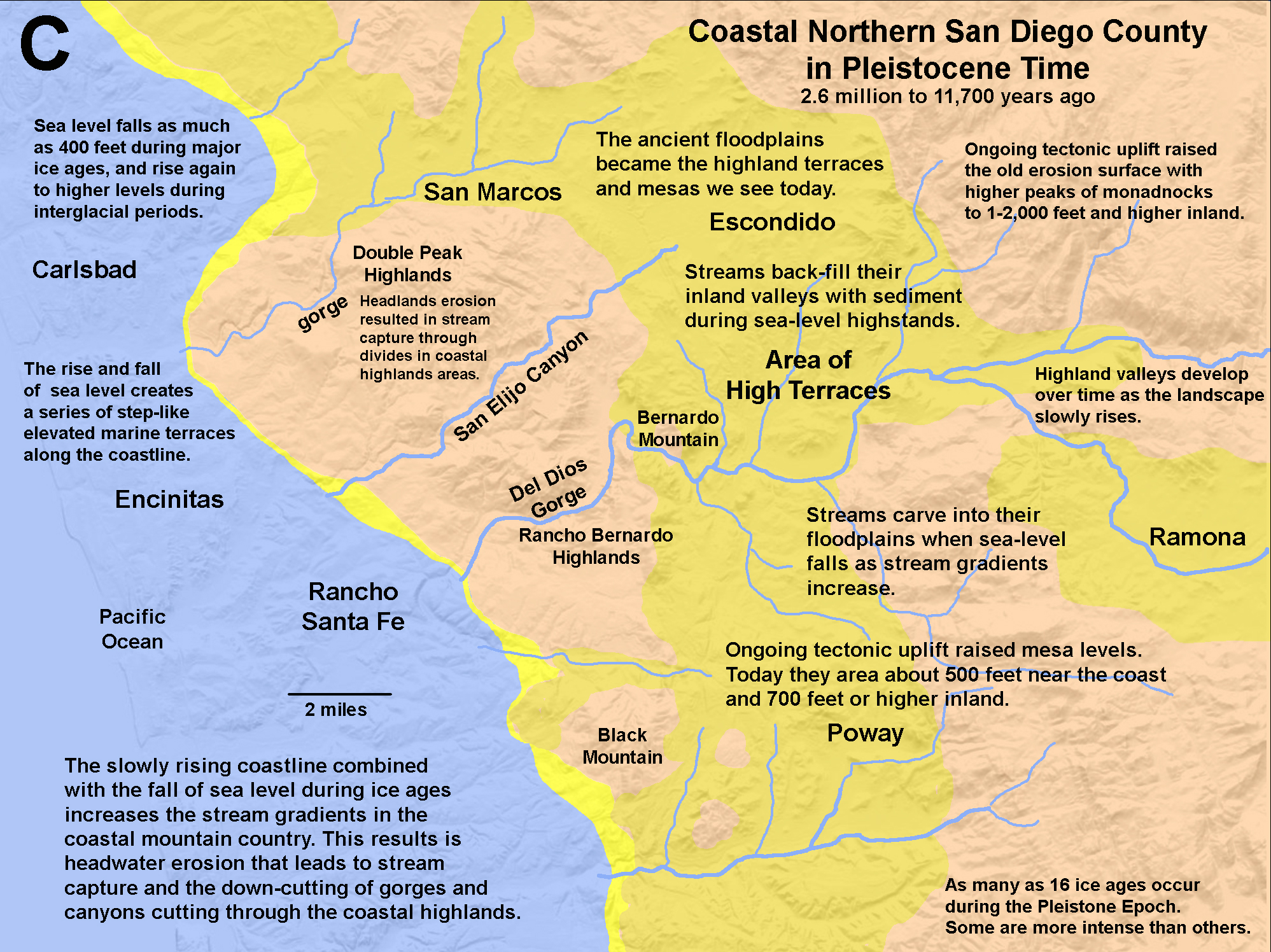
After about 45 million years ago, major geologic changes began to reshape the regional landscape. A large block of lithosphere that included Baja California, San Diego County, and the Peninsular Ranges of Southern California began to split away from the rest of the North American Plate, forming the greater San Andreas Fault system (and associated region faults). Likewise, large fault-bounded blocks of the crust on the Pacific side of the peninsula began to split away, eventually becoming the islands and seamounts in the Borderlands region of offshore southern California we see today.
|
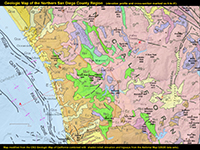 Fig. 14. Geologic map of northern San Diego County.
 |
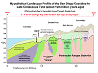
Fig. 15. Landscape during Late Cretaceous time. |

Fig. 16. Landscape during Late Eocene time. |
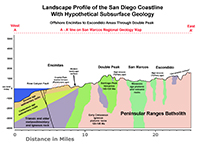
Fig. 17. Modern landscape geologic profile. |
|
| The San Pasqual Valley has evolved over time in step with the changes that have shaped the SoCal Peninsular Ranges. Ancient river systems that once drained from the Sonora, Mexico highlands were diverted as Baja California rifted away from the North American continental plate, forming the Gulf of California and Imperial Valley. For example, the ancestral rivers that existed before the modern Colorado River were diverted and no longer flowed to the Pacific coastline. As the San Andreas Fault system developed, the San Diego region lost its large rivers that once flowed across the landscape and shaped the peneplain (remnants are still preserved as the "Old Erosion Surface" level shown on Figure 18). |
A7
Area of High Terraces - Highland Mesas and Monadnocks
San Pasqual Valley and surrounding highlands falls within a physiographic region called the Area of High Terraces (Figure 18). When you view the the region from any of the local higher peaks you can see that the highlands have a limited range of elevations (Figures 19).
The Area of High Terraces is an erosional-dissected plateau (or mesas) that was once at the the level of an ancient coastal plain and/or continental shelf embayment back in Tertiary time (Eocene to possibly Miocene time, 45 to 20 million years ago). Since Miocene time the land associate with the Santa Ana tectonic block has very slowly risen almost 1000 feet. Ancient sedimentary deposits consisting of beach-rounded cobbles and stream gravels can still be found in local pockets in the highland terrace areas. The higher mountain peaks are erosional remnants (called monadnocks) that at one time may have been islands or coastal headlands along the ancient shoreline. The modern stream valleys have been carved into these ancient surfaces as the lands has risen. Ancient stream terrace deposits consisting of older, reworked materials can be found in many areas along the local areas. Areas of old alluvium (Early to Late Pleistocene age) are shown as Qoa on the geologic map, Figure 4). |
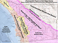 Fig. 18. Physiographic provinces of San Diego County. The Area of High Terraces is part of the stable Santa Ana tectonic block. Fig. 18. Physiographic provinces of San Diego County. The Area of High Terraces is part of the stable Santa Ana tectonic block. |
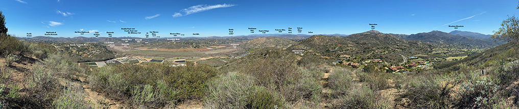
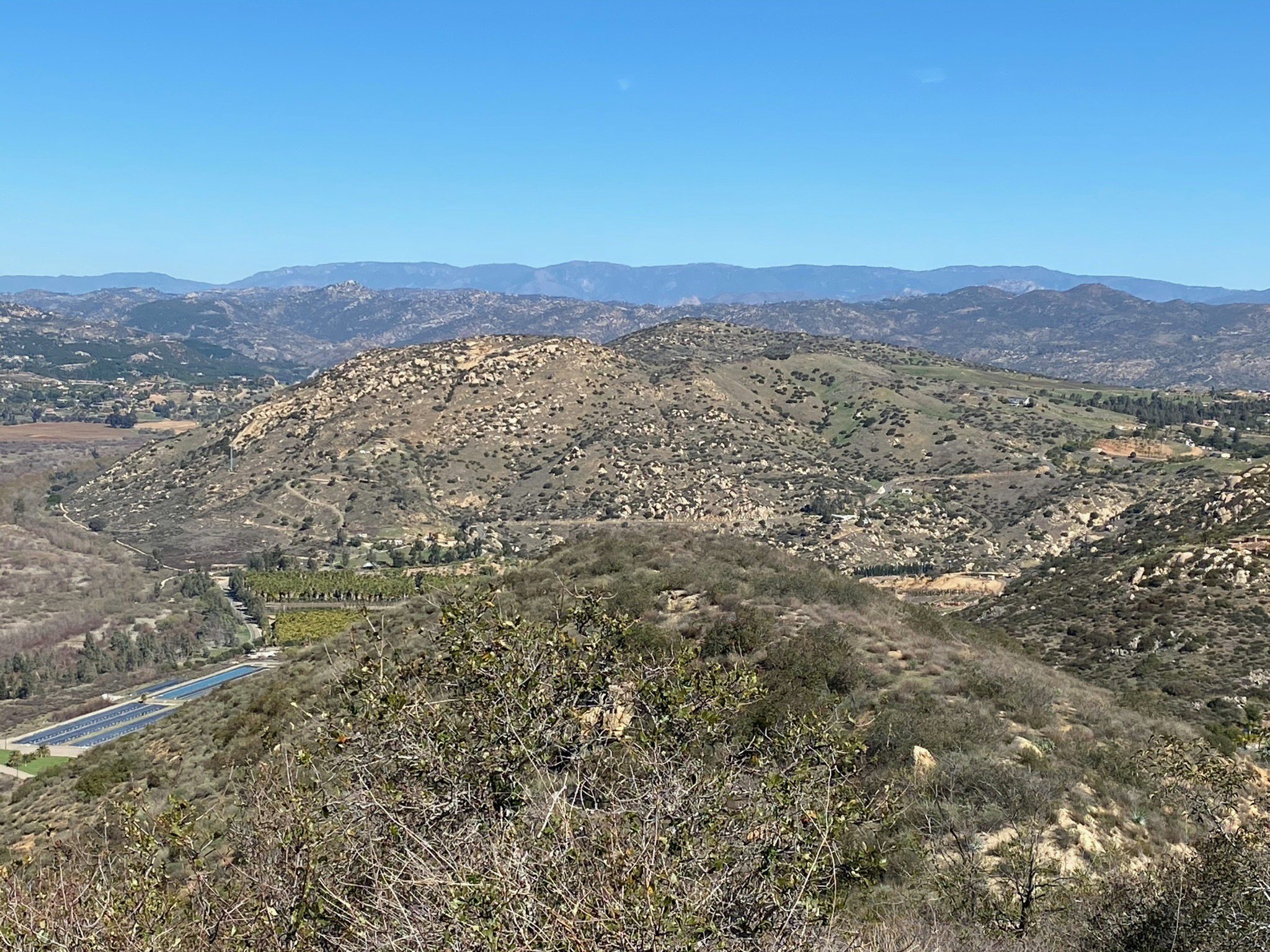
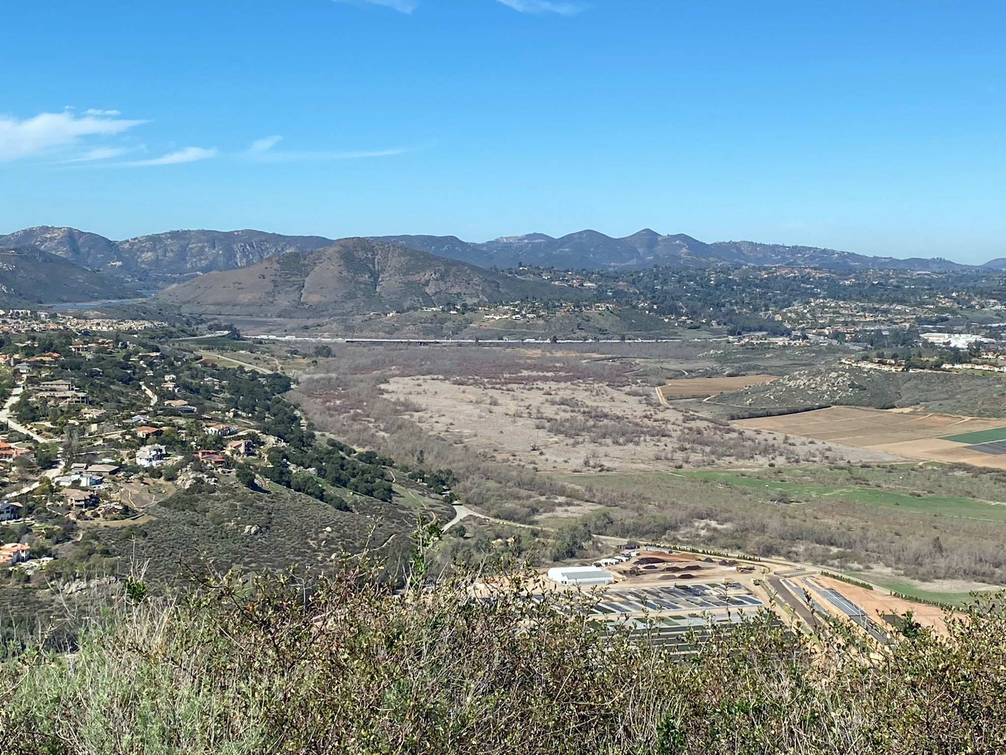
| Fig. 19. Panoramic view from Sycamore Ridge"Water-Tank Peak" (elevation 1,050 feet), the peak is located near the Old Coach Trail on the south side of San Pasqual Valley. Higher peaks and mesa elevations are labeled. The High Terraces (mesas) level averages between 700 to 800 feet in the vicinity of Escondido and Rancho Bernardo. Higher peaks are monadnocks on this ancient surface. San Pasqual Valley is about 300 feet near the I-15 Bridges, and about 440 feet at its eastern end (8 miles to the east). |
A8
Changes To the Landscape Over Time - Eocene to Present
Figures 20 to 23 illustrate how the regional geography may have changed over time.
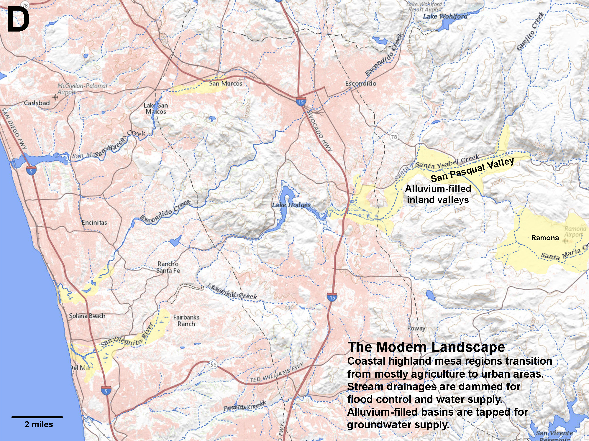
By Late Eocene Time (about 45 million years ago), the ancient mountainous landscape associated with the Cretaceous volcanic arc had worn down to a low peneplain. Low hills and scattered peaks rose above broad river flood plains and a coastal plain along the coastline. Some of the peaks in the coastal highlands were possibly islands or headlands surrounding a large embayment along the coastline (Figure 20). The embayment region was scoured by wave action, creating a relatively flat inland extension of the continental shelf. As time progressed, the coastal region began to steadily rise, and the embayment region began to rise and the continental shelf became a coastal plain (Figure 21). With ongoing uplift and then elevated terraces or mesas divided by incised stream valleys. When the ice ages of the Pleistocene began, sea level dropped as continental ice sheet formed. Drops in sea level, as much as 400 feet during ice ages were followed by rises in sea level, as much as 60 feet higher than today during interglacial periods. When sea was low, and the climate was wetter, streams draining the coastal highlands carved into downward and expanded their headwaters region, eventually capturing streams east in the highland valleys to the east. With each rise and fall of sea level, at least 16 times during the Pleistocene Epoch, streams would backfill their valleys with sediments, and carved downward through their floodplains when sea-level fell again (Figure 22). Since the end of the last ice age, about 11,700 years ago, sea level has risen about 400 feet, and continues to rise. Today, the highland terraces (mesas) are mostly utilized for urban development, and mountainous area are increasingly preserved as open space and watershed (Figure 23). |
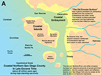
Fig. 20. Generalized paleogeographic map of northern San Diego County representing Eocene time. |

Fig. 21. Generalized paleogeographic map of northern San Diego County representing Miocene time. |

Fig. 22. Generalized paleogeographic map of northern San Diego County representing Pleistocene time. |
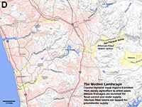
Fig. 23. Map of the modern geography of the northern San Diego County region showing shallow alluvial basins. |
|
A9
Landscape Development: Hill-slope Mass Wasting and Erosional Processes
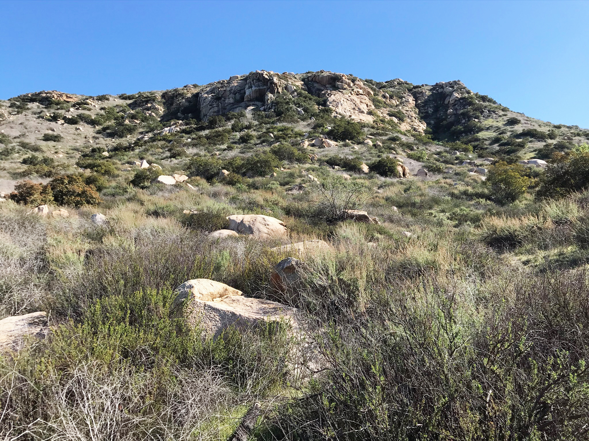
San Diego County has a relatively stable Mediterranean climate, having long dry summers, and cooler, wetter winter seasons. However, the climate basically swings from from drought to non-drought conditions in multi-year cycles. The average rainfall in the San Pasqual Valley area is about 9 inches per year. The much-longer-term climate changes—measured in decade, centuries, or millennia—are less understood, but there have been long periods of wetter, cooler climates as well as extended severe droughts. As a result, the natural landscape has evolved with climate-controlled erosion cycles. During longer, wet periods dense vegetation cover cuts down on surface erosion and deep-weathering soil profiles developed with the additional moisture. Eventually, droughts would lead to massive wildfires, loss of vegetation cover. During long drought periods, infrequent but intense rainfall stripped away the soil cover, often leaving spheroidal-rounded granite boulders and scattered bedrock outcrops exposed at the surface. For example, Figure 24 shows the landscape in the Raptor Ridge area that are covered with granite boulders and barren bedrock outcrops. Boulder-covered mountainsides have pretty much evolved since since pervasive drought periods began at the end of the last ice age. Loose soil and regolith easily gets eroded away in slopewash after infrequent storms.
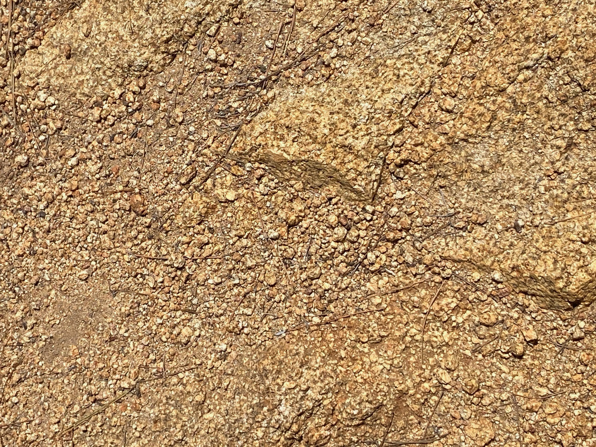
Colluvium: Geologic maps do not show details about the colluvium cover on hill slopes. In many areas along the sides of the valley large boulders cover the surface below scattered bedrock outcrops (Figures 25 and 26). Many of the boulders may have tumbled down from their source areas, others gradually move down the slope under the influence of gravity, occasional earthquake shaking, and other mechanical weathering and erosion processes, sometimes resulting in rockfalls, landslides and debris flows. Figure 27 shows a cut along the Old Coach Trail where heavily weathered granitic rock is exposed. Chemical weathering processes have degraded the more soluble minerals (mafic minerals and feldspars) to the point the the rock easily crumbles in your hand. Intense rains wash loosened sediment from these degraded bedrock areas and carries it as slopewash where it is deposited as alluvial fans along the valley floor. Occasional heavy streamflow picks of these loose materials and eventually transports it to the ocean (except now, it remains trapped on the floodplain, in the wetlands area, and in Lake Hodges.
|
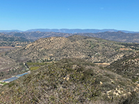
Fig. 24. Granite outcrops and boulder-covered highlands on Raptor Ridge and vicinity. |
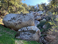
Fig. 25. Massive granite boulders along the Raptor Ridge Trail. |
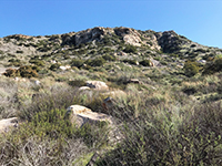
Fig. 26. Boulders and colluvium below outcrops along Raptor Ridge Trail. |

Fig. 27. Deeply weathered granitic rock easily crumbles in your hand. |
|
A10
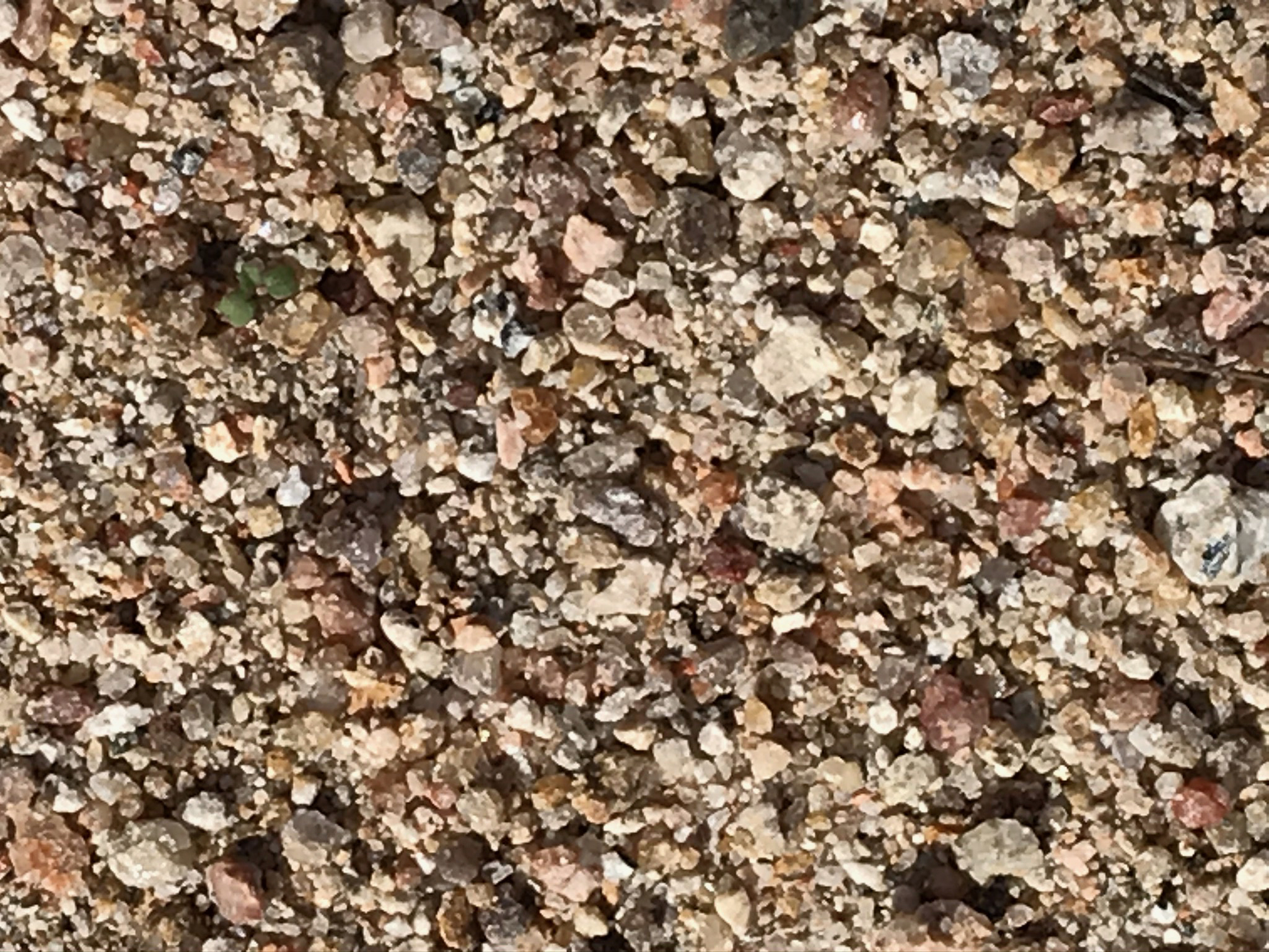
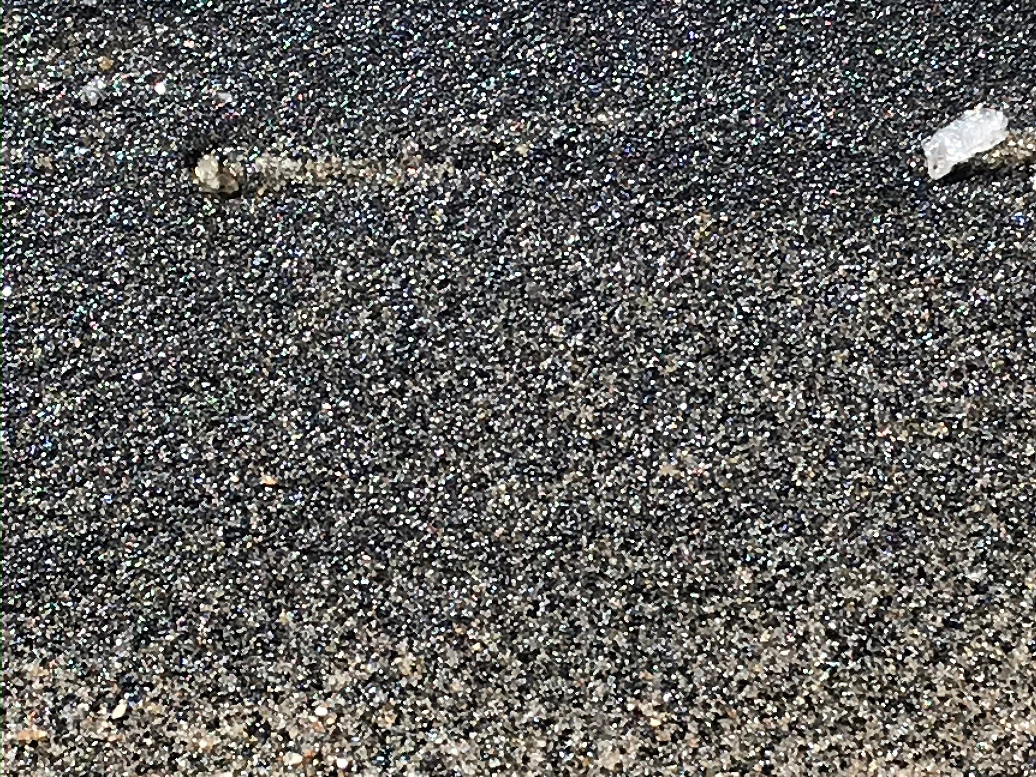
Alluvial Deposits: Alluvium is considered any kind of sedimentary deposits that was created or modified by stream action. Figure X shows a close-up of fairly well-sorted coarse sand and fine gravel from the Santa Maria creek bed. It consists mostly of fragments of feldspar and quartz grains derived from granitic rocks. Figure X shows a bed of medium-grained black sand, mostly magnetite, concentrated by sorting processes associated with stream flow. Areas underlain by young alluvial deposits are shown as Qya and Qsu symbols on the geologic map (Figure X).
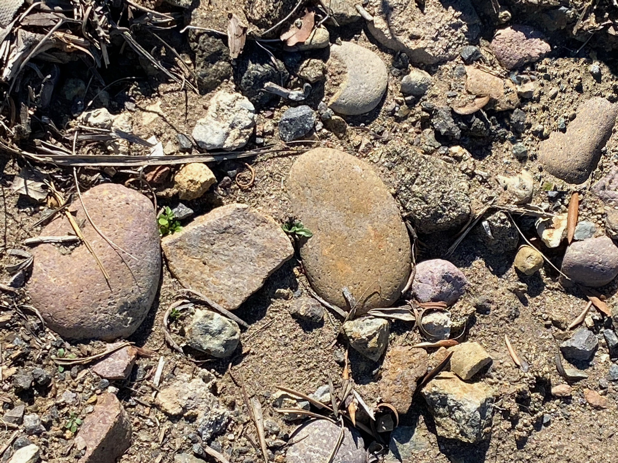
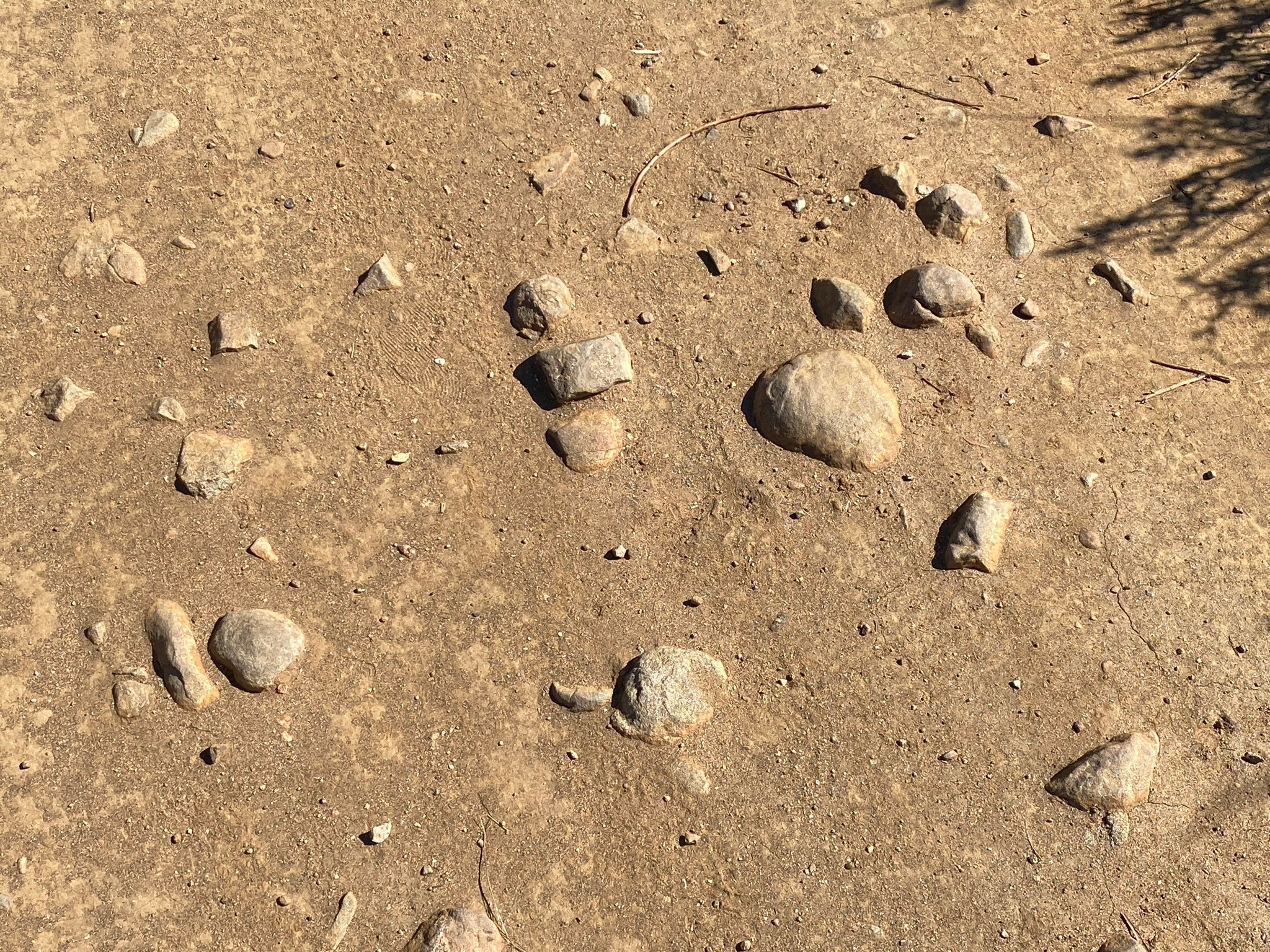
Stream Terrace Deposits: Older alluvial deposits are locally preserved along the margins the the stream valleys. These old Quaternary alluvium deposits are shown as Qoa on the geologic map (Figure X). Figure X shows old stream terrace gravels exposed along the lower hillsides along the Old Coach Trail. Figure X show old stream terrace gravels exposed in the Highland Valley Trail. Some of the smooth, very well rounded cobbles are similar to beach cobbles and stream gravels reworked from older Eocene age coastal deposits that may have covered the Area of High Terraces in the distant past. Some of the clasts are composed of volcanic rocks that were derived from ancient rivers that drained to the coast of the Sonora, Mexico highlands region before the formation of the San Andreas Fault and the opening of the Gulf of California in Miocene time. These cobbles have probably endured many cycles of erosion and deposition over their long geologic journey. |
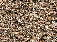
Fig. 28. Coarse sand and gravel in the stream bed of Santa Maria Creek. |
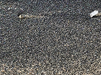
Fig. 29. Fine, well sorted black sand deposit n the stream bed along Santa Maria Creek. |
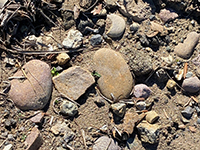
Fig. 30. Elevated stream terrace gravel deposit along the Old Coach Trail. |
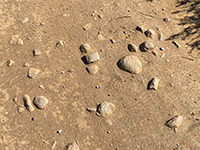
Fig. 31. Elevated stream terrace gravel deposit exposed on the Highland Valley Trail. |
|
A11
Hydrology Of the Watershed
Figure 32 shows a map of the San Dieguito River watershed region that includes the San Pasqual Valley. The San Dieguito River begins at the confluence of its two principle streams, Santa Ysabel Creek and Santa Maria Creek. The confluence is located at San Ysabel Road in the community of San Pasqual (Figure 33, Santa Ysabel Creek is to the left, Santa Maria Creek is to the right).
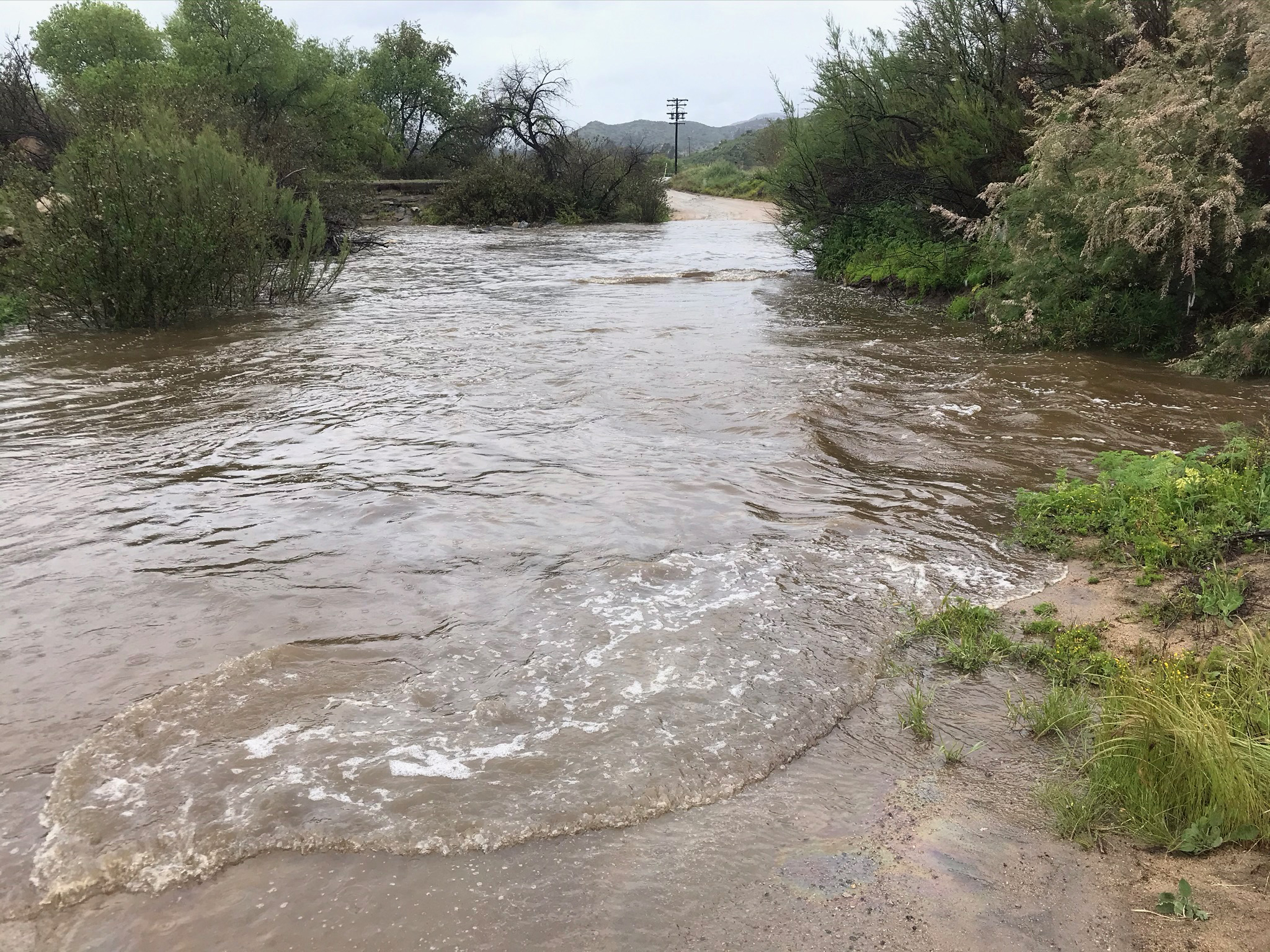
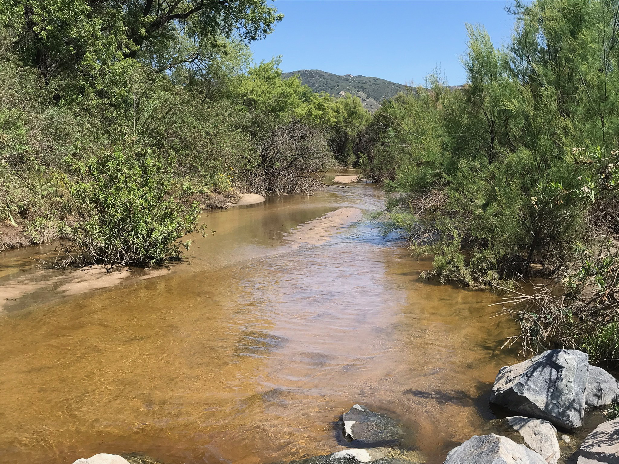
Figures 34 to 36 show the results of flooding and stream flows after a period of heavy rains in early April, 2019. Most of the year there is no water flowing in the stream beds in the valley. However, because of the porous nature of the grussy alluvial sediments, most water entering the San Pasqual Valley quickly sinks into the ground, recharging the groundwater basin where water flows underground, with no surface streamflow (Figures 37 to 39). |
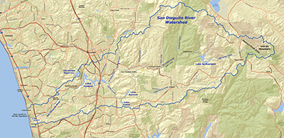
Fig. 32. Map of the San Dieguito River watershed region. The drainage basin extends from the ridgelines in the Peninsular Ranges near Julian to the river mouth in Encinitas, CA. |

Fig. 33. Confluence of Santa Ysabel Creek and Santa Maria Creek in San Pasqual Valley. |
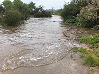
Fig. 34. April, 2019 flood on Santa Maria Creek at Ysabel Creek Road. |
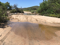
Fig. 35. A new sand bar formed across Ysabel Creek Road after the 2019 flood. |

Fig. 36. Groundwater discharge (clear water) flow feeds in Santa Maria Creek. |
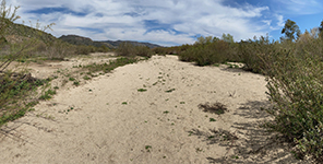
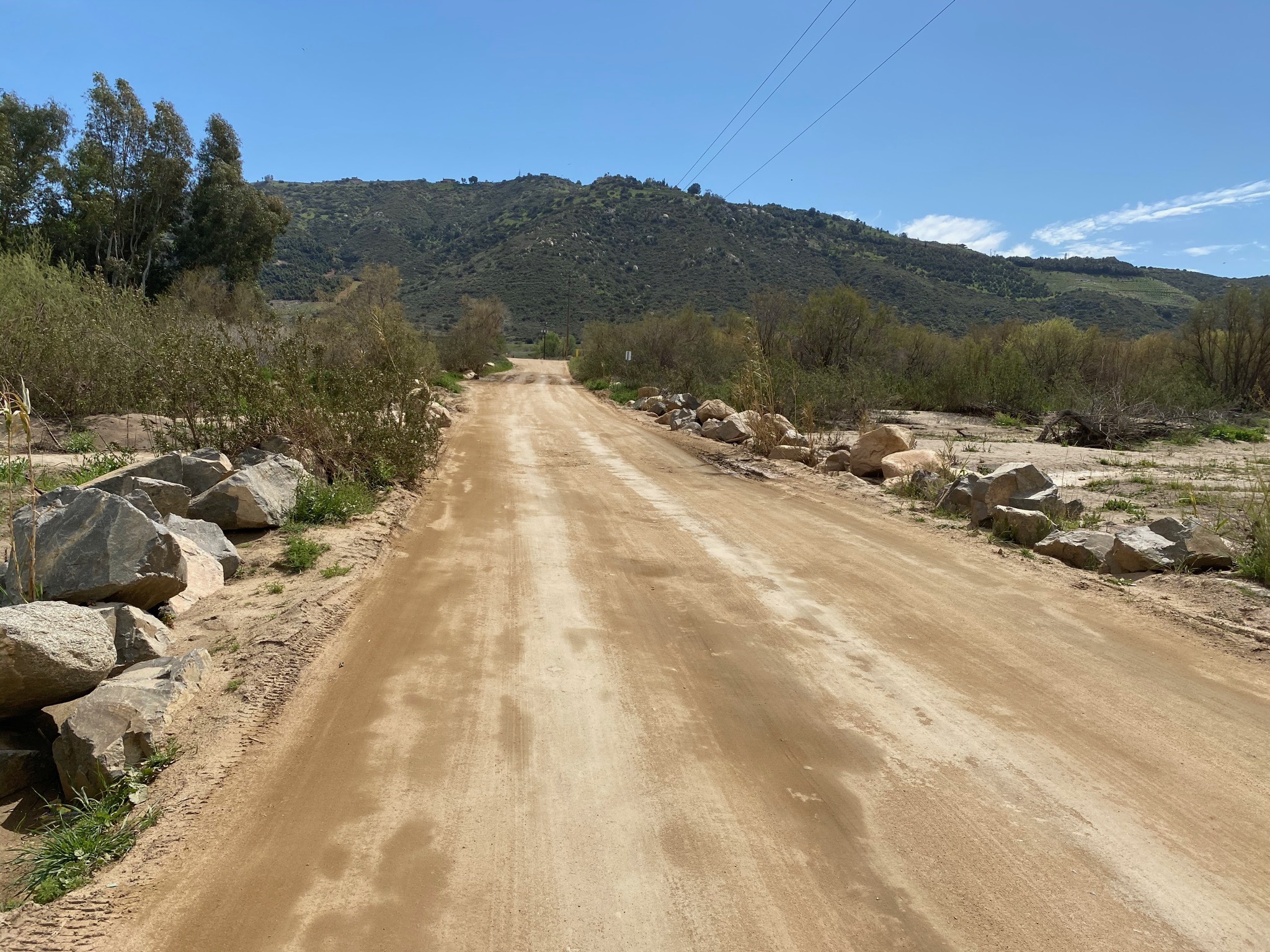
Fig. 37. Santa Ysabel Creek upstream of Ysabel Creek Road in March 2021. |

Fig. 38. Stream crossings on Ysabel Creek Road |
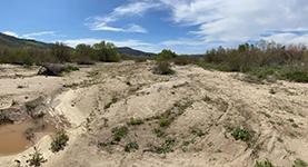
Fig. 39. Santa Ysabel Creek downstream of Ysabel Creek Road in March 2021. |
|
A12
The San Pasqual Valley—A Hydrologic and Groundwater Basin
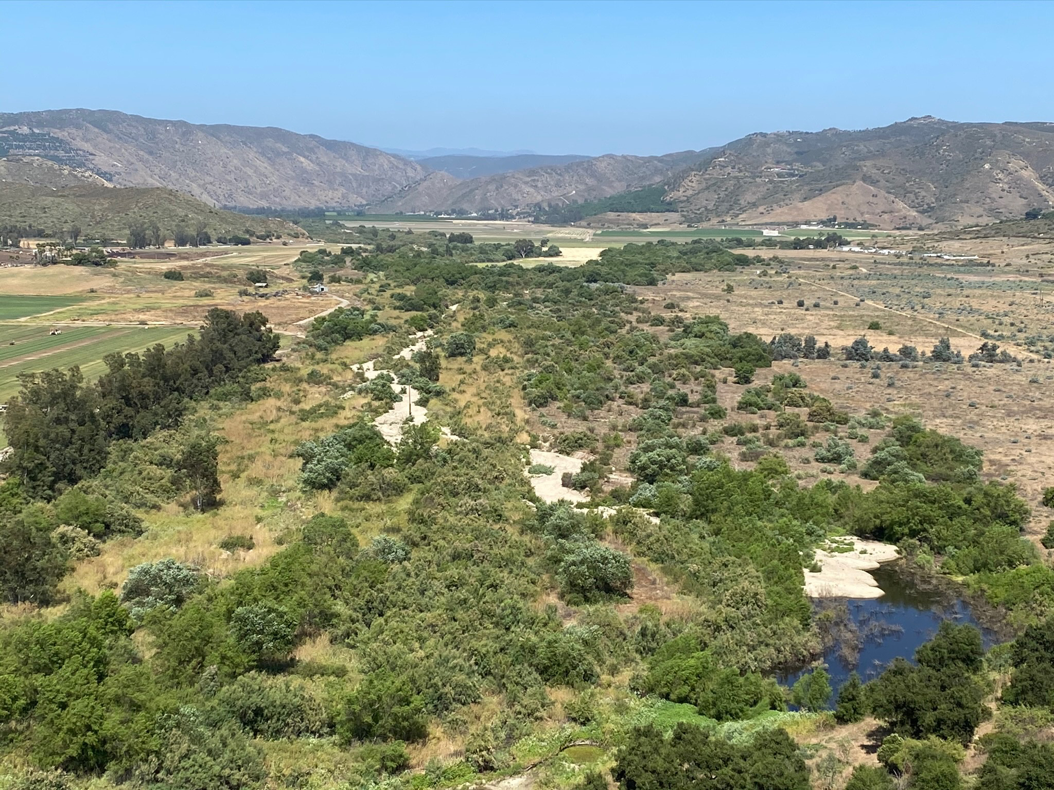
Streams draining into the valley re-supply the San Pasqual Valley Groundwater Basin. The San Pasqual Valley is underlain by a shallow alluvium-filled groundwater basin—an unconfined aquifer.
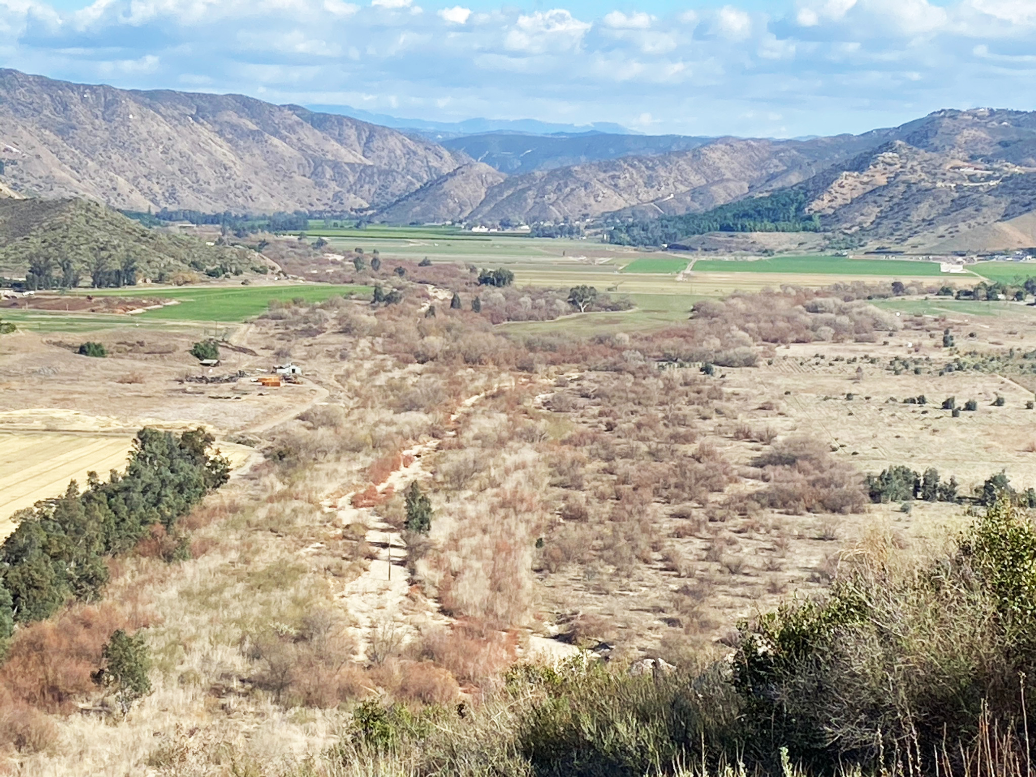
The groundwater basin extends from near the mouth of Clevenger Canyon where sediments deposited by Santa Ysabel Creek and other tributaries. The sediments have filled in a once deeper valley that had been carved during deep-stage erosion cycles during the Pleistocene ice ages. The sediments that fill the basin are mix of gravel, sand, silt, and clays that were deposited in a variety of sedimentary settings similar to what can be seen where sediments are accumulating in the valley today (Figures 40 to 42). The sides of the Vally are gently sloping aprons of coalescing alluvial fans consisting of a poorly sorted mix of coarse grained sediments. These sediment deposits merge with dominantly well-sorted sand deposits in the trunk stream channels in the valley. The broader floodplains are underlain are a mix of finer sand, silt, and clay (mud) beds deposited in over-bank and wetland areas. Figure 43 is a view looking east under the Interstate 15 bridges where muddy flood-stage waters in Lake Hodges are back-filling into the wetlands in west end of San Pasqual Valley (during the floods of early March, 2017).
The valley-fill sediments are thickest near its upstream eastern end (close to 300 feet thick) and thins until it basically pinches out in upper canyon now flooded by Lake Hodges. The valley fill is an unrestricted aquifer that is recharged by inflowing floodwaters and limited precipitation. The San Pasqual Valley aquifer is the 4th largest groundwater reservoir in San Diego County. The groundwater supply is heavily utilized by agricultural and municipal water supply. Steps are being taken to try to manage groundwater quality issues in the valley. |

Fig. 40. View looking east (up valley) toward Clevenger Canyon in the distance. |
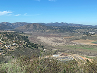
Fig. 41. View looking west (down valley) toward Lake Hodges and Interstate 15. |
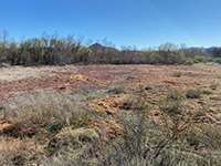
Fig. 42. View of floodplain wetlands in the lower end of the valley near Lake Hodges. |
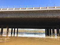 Fig. 43. Muddy waters in east end of Lake Hodges during the floods of March, 2017. Fig. 43. Muddy waters in east end of Lake Hodges during the floods of March, 2017. |
|
| The San Pasqual Valley has problems with water quality and water supply issues. Because of the dry climate and the geochemistry of the rocks throughout the headwaters region, the natural waters draining into the basin are naturally high in total dissolved solids (TDS). The aquifer is intensely utilized for agriculture irrigation and local community water supply. Long term usage of fertilizers on fields, and feed-lots wastes have created high nitrate concentrations. Evapoconcentration of groundwater salts from recycling irrigation waters as well a the natural, passive concentration of salts by riparian vegetation also increase TDS concentrations. As a result, more salts are currently entering the aquifer than are being removed, resulting in an increase in TDS over time (Isbell and others 2015). Efforts are being made to resolve groundwater quality and supply issue through better management of the basin, but nothing is easy. Figure 44 is a view of the Aqua III Reclamation Facility and Aqua 2000 Research Center in the San Pasqual Valley (view from the Old Coach Trail). The City of San Diego supported development of an experimental aquaculture-waste water treatment facility in the 1990s, but the experiment proved to be too costly and failed to generate enough revenue to maintain operation, and its use was discontinued in 2001. |
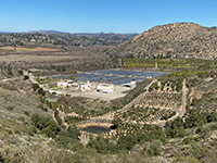
Fig. 44. Aqua III Water Reclamation Facility and Aqua 2000 Research Center. |
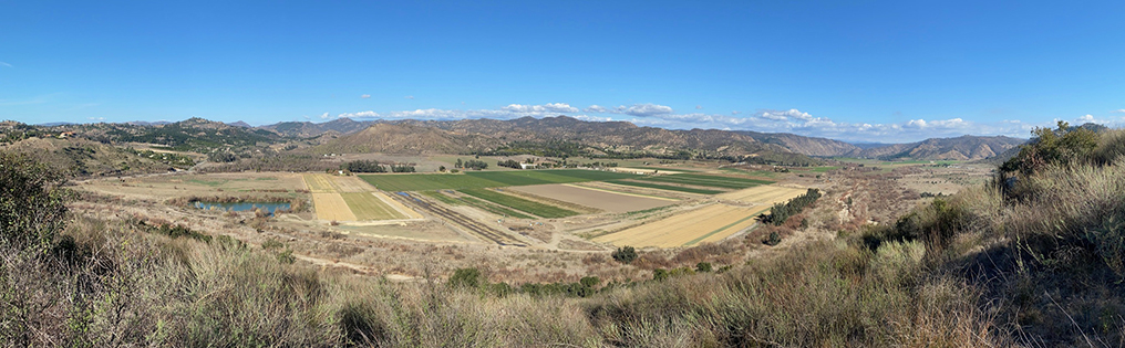
Fig. 45. This panoramic view from the Raptor Ridge Trail shows agricultural fields (part of the SDRP Agricultural Preserve) in the upper San Pasqual Valley and feed lot on the opposite side of the valley. Roughly 2,500 acres of the valley are used for agricultural purposes each year, most of which uses irrigation. The view also show the riparian habitat along the the stream valley. An infiltration pond to the left shows the level of the shallow groundwater table in this section of the valley. |
A13
Plant Communities
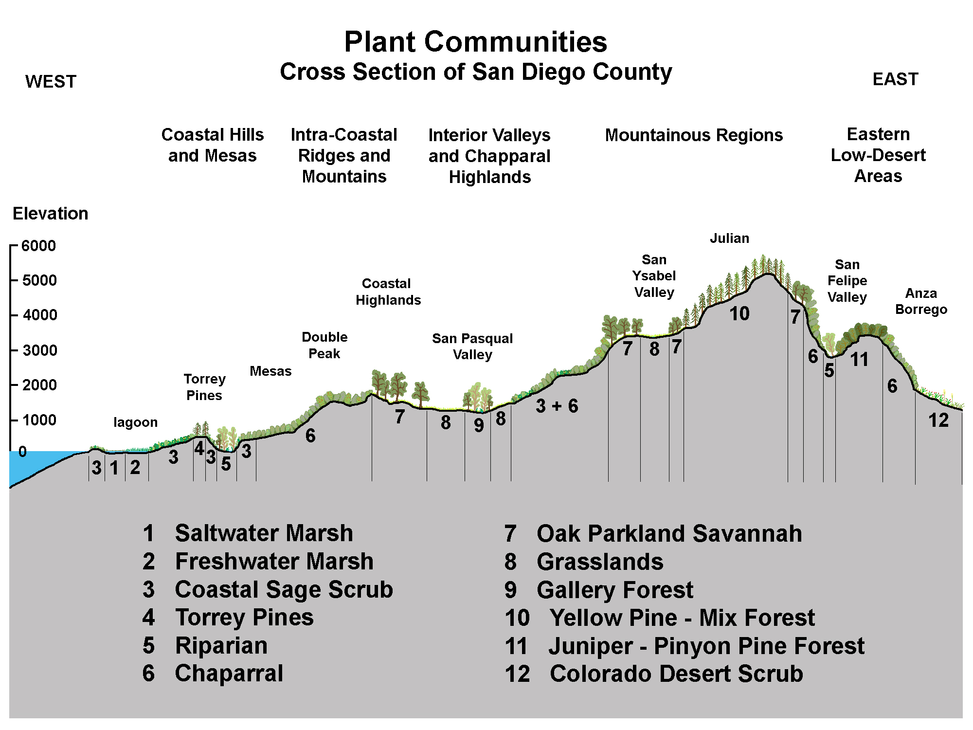
San Diego County's landscape provides habitats for an extensive diversity of plant life. The different plant zones are classified in different ways, but generally follow geography designations including coastal hills and mesa, intra-coastal ridges and mesas, interior valleys, mountainous regions, and the eastern low-desert areas (Figure 46). However, plant communities are mixed and overlap without clearly defined boundaries. Species may vary by precipitation levels, slope orientation, elevation, soil types, land-use history, and other microclimate characteristics. The native habitat are largely undisturbed on the rugged hillsides. However, centuries of cattle grazing, wildfires, urban sprawl, and introduction of non-native grasses, eucalyptus, and other invasive species have altered the plant communities. |
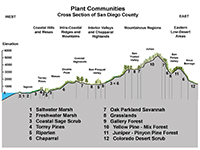
Fig. 46. Plant communities. |
A14
Wildfire In the San Pasqual Valley Area
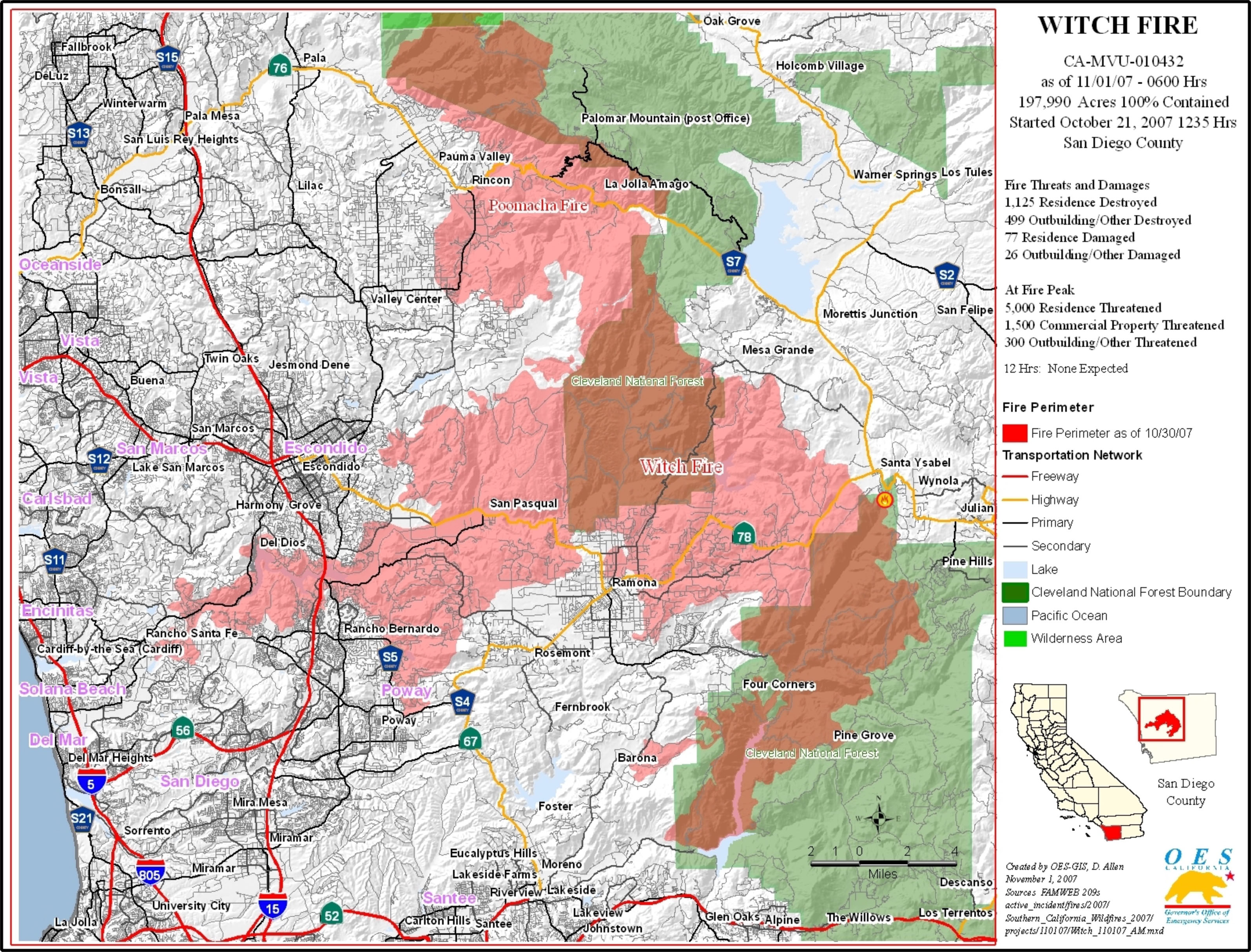
Most visitors to the San Pasqual Valley area today probably won't see the evidence of the massive 2007 Witch Creek Fire that burned through the entire valley and surrounding mountainsides (Figure 47). The fire caused catastrophic damage to both the wild lands and residential communities within the burn area. Most of the wildlife habitat along the stream valleys were completely consumed by the fire. The San Dieguito River Park has been working with many conservation groups to try to restore lost habitat for threatened and endangered plant and animal species native to the area. It is important to add that many of the native plant species are adapted to fire ecology. Wildfires have burned though the region episodically for thousands of years, and longer—a natural processes that contributes to the gradual shaping of the regional landscape. |
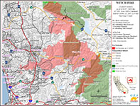
Fig. 47. Map of the 2007 Witch Creek Fire burn area |
A15
Human Impacts
The San Pasqual Valley story provides an interesting reflection on the tremendous amount of change happening in the region. The Rancho Bernardo, Escondido, and San Diego historical societies each provide a useful timeline of the history of the San Pasqual Valley and San Diego region (see Selected Resources below). Humans have been impacting the landscape well back into prehistory into the last Ice Age.
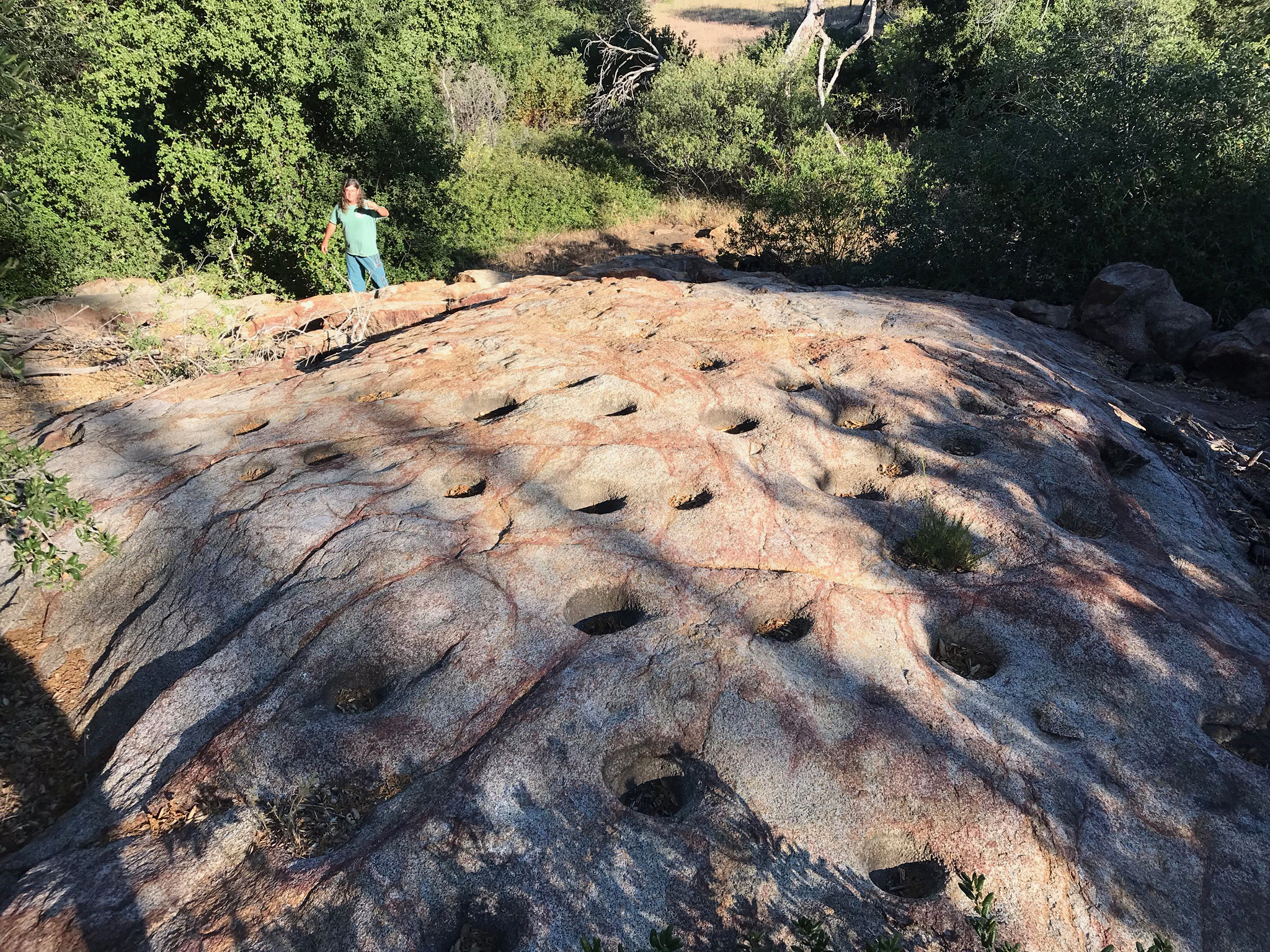
Humans may have settled in the coastal San Diego area as early as 20,000 years ago (San Diego History Center, 2020). Very little remains of the evidence of the first peoples to migrate through the region. It must have occurred during the peak of the last ice age, but sea level has risen 400 feet since then, erasing the traces of coastal populations. We can see some evidence of ancestral peoples mark on the landscape (Figure 48).
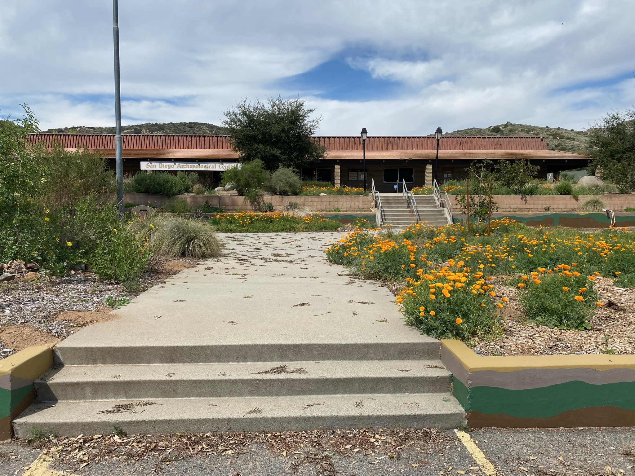
The San Diego Archaeological Center in San Pasqual Valley is the ideal place to go, see, and learn about ancestral peoples and the tribes that lived and live here before and during the arrival of the peoples of Spanish- and European- descent (Figure 49). How the populations changed in prehistoric times is unknown, but there were waves of migrations coming into the region. Evidence of the impact of climate change on human populations can be easily seen in the eastern part of San Diego County where it is still possible to see the remnants of shoreline communities on ancient Lake Cahuilla that existed in the Salton Trough region up to about 500 years ago before it finally dried up. Lake Cahuilla was one of the largest post-Ice Age lakes that existed in the SoCal desert region. During the last Ice Age it was a freshwater lake covering over 2,000 square miles and a depth of more than 300 feet. The climate was very different, colder and wetter, and pine forests probably extended from the mountains all the way to the coastline.
It is estimated that there were about 20,000 native people in the San Diego region about the time Spanish explorer Juan Rodriguez Cabrillo arrived and claimed San Diego area for Spain in 1542. That population crashed at the expense of pandemics and warfare as the Spanish migrated into the San Diego region. San Diego came under Mexican rule for about 25 years starting in 1821.
Next door to the San Diego Archaeological Center is the San Pasqual Battlefield State Historic Park and Museum. The Battle of San Pasqual Valley occurred in December of 1846. It was among the first conflicts between the Californians and Americans in the West. Mexican occupation ended with the conclusion of the war between Mexico and the United States in 1848 just prior to the California Gold Rush of 1849. The first census of "non-Indian" population of San Diego was 650 people in 1850. The historic topographic maps shown in Figure 3 illustrate how rural northern San Diego still remained around the year 1900. Since then the population has grown in waves, first with a spike after WW1, another after WW2, then the SoCal population boom starting in the 1960 to the present.
What is clear is San Diego County has long passed "self-sustainability" (depending on how you define it).
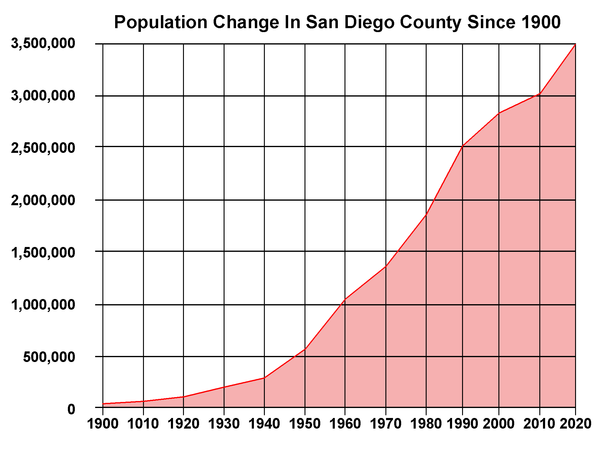
More water is pumped into the county than naturally flows in all of its rivers and streams. Most of the food, consumable products, and construction materials are imported from elsewhere. Yet, the county population continues to grow. The US Census data for 2020 puts the county at just over 3.5 million people (Figure 50). Although California's population growth has somewhat leveled off, San Diego continues to grow at roughly 12% per decade.
Perhaps an icon of our modern times is the 16 lane of traffic crossing the Interstate 15 bridges over the San Dieguito River between Rancho Bernardo and Escondido (Figure 51). Perhaps some good news its that with regional development has come better land management planning and watershed protection. The San Pasqual Valley is, hopefully, protected from further widespread development with the "SDRP Agricultural Preserve" and the park lands and wetlands protection throughout the valley. |
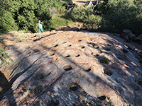
Fig. 48. Rock with grinding mortars holes near Julian. |

Fig. 49. San Diego Archaeological Center |
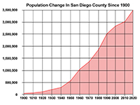
Fig. 50. Population census for San Diego County 1900-2020. |
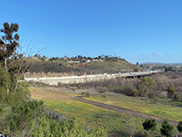
Fig. 51. Interstate 15 with 16 traffic lanes on river bridges. |
|
A16
Selected Resources
Berger, W.H., 2013, On the Natural Geography of North San Diego County. Essay prepared for the San Dieguito River Valley Conservancy. (link)
City of San Diego. Fire-Rescue Department, 2007 - Witch Creek and Geujito Fires. (link)
City of San Diego, Water Resources Department, 2006, Water Reuse Study, Section 3.0 Development and Supply Availability of Recycled Water, 11 p. (link).
Escondido History Center, Escondido - A Timeline: Escondido History: website (link)
Isbell, B., Hammond, L., Henderson, T, and Daly, K., 2015, San Pasqual Groundwater Management, State of the Basin Report: City of San Diego, Public Utilities Department, Long Range Planning and Water Resources report, prepared by CH2MHILL, 50 p. (link)
Kistler, R.W., Wooden, J.L., and Morton, D.M., 2003, Isotopes and ages in the northern Peninsular Range: U..S. Geological Survey, Open-File Report 03-489. (link)
Larson, E.S., Jr., 1948, Batholith and associated rocks of the Corona, Elsinore, and San Luis Rey quadrangles, southern California: Geological Society of America Memoir 29, 182 p.
Rancho Bernardo Historical Society: Rancho Bernardo Timeline of Historic Events. website with .pdf: Poster of Timeline of Historic Events. (link)
San Diego History Center, 2020, Timeline of San Diego History: website. (Link)
San Dieguito River Park (official website). (link)
San Dieguito River Valley Conservancy (official website). (link)
San Dieguito River Park, Coast To Crest Trails At San Pasqual Valley (brochure with map).
|
| https://gotbooks.miracosta.edu/fieldtrips/San Pasqual_Valley/index.html |
3/18/2021 |
|
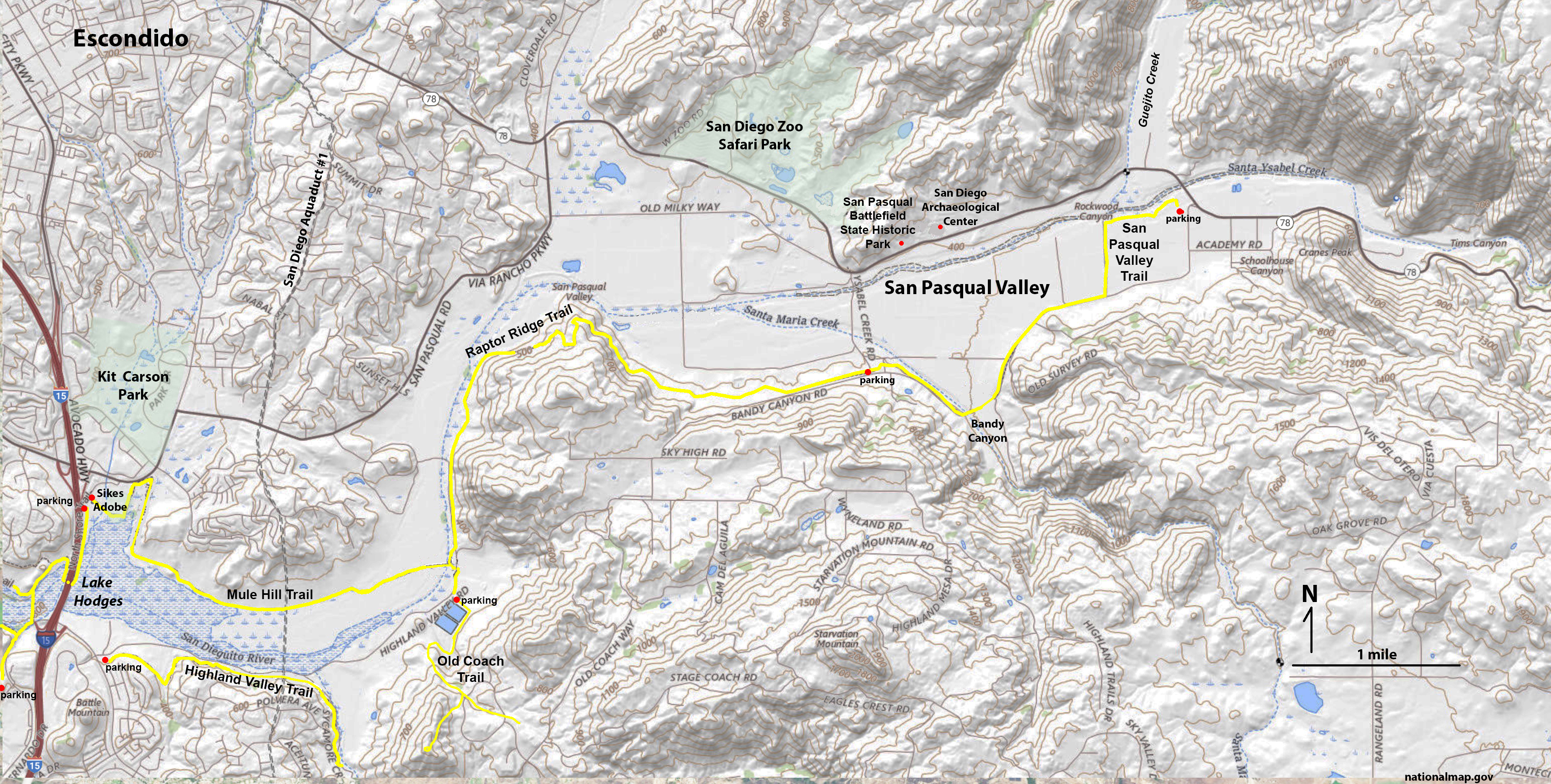
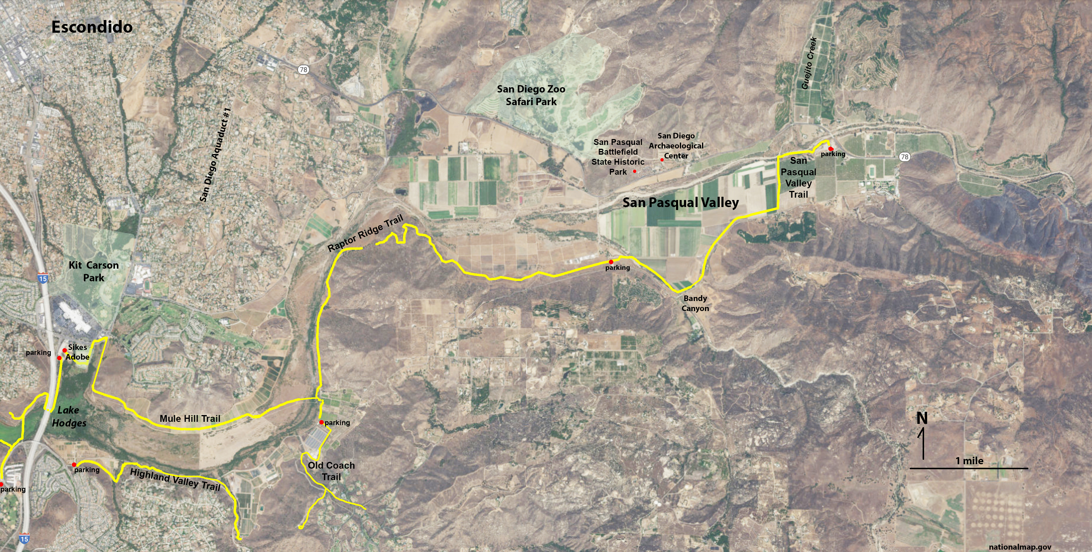
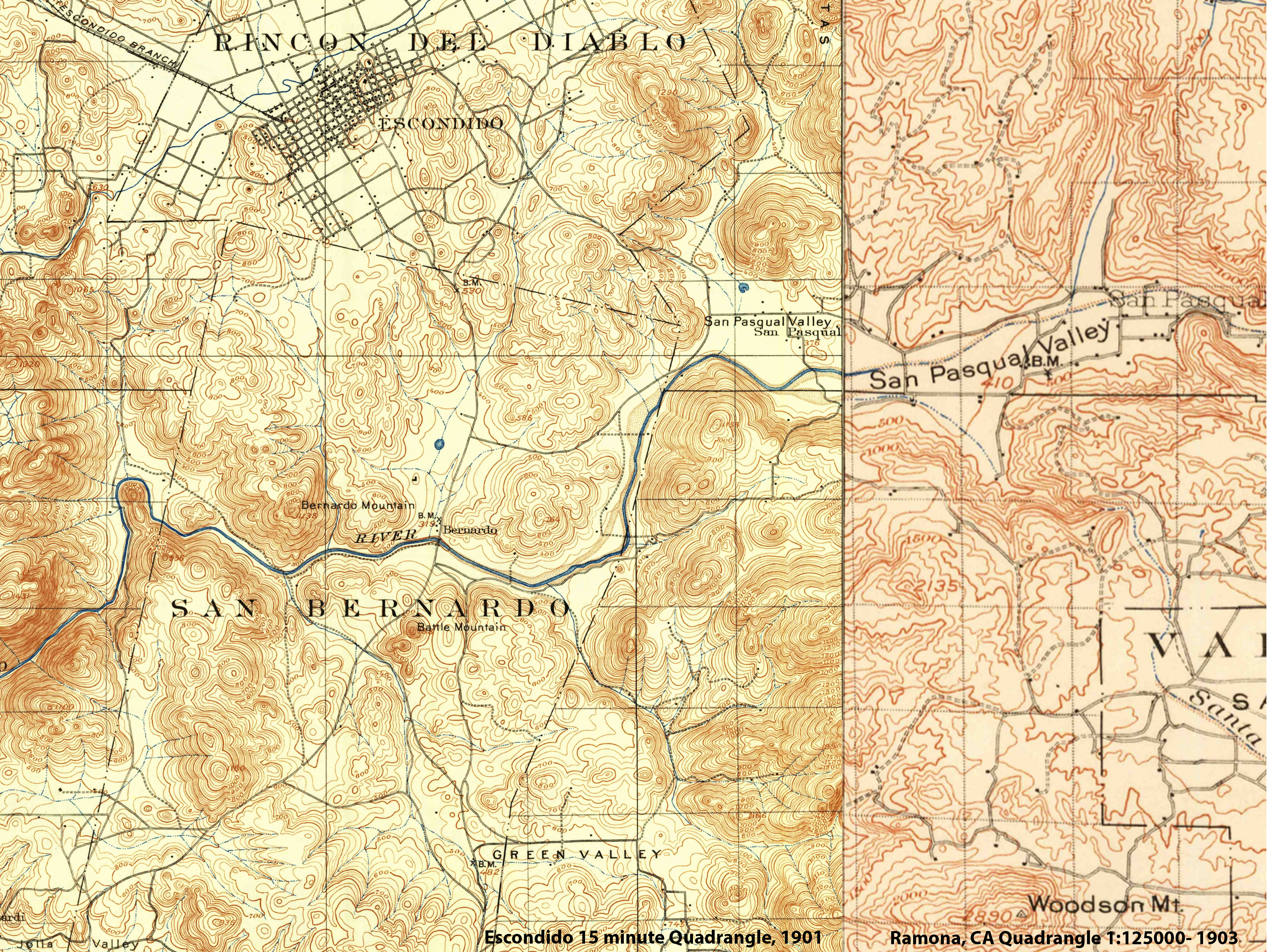
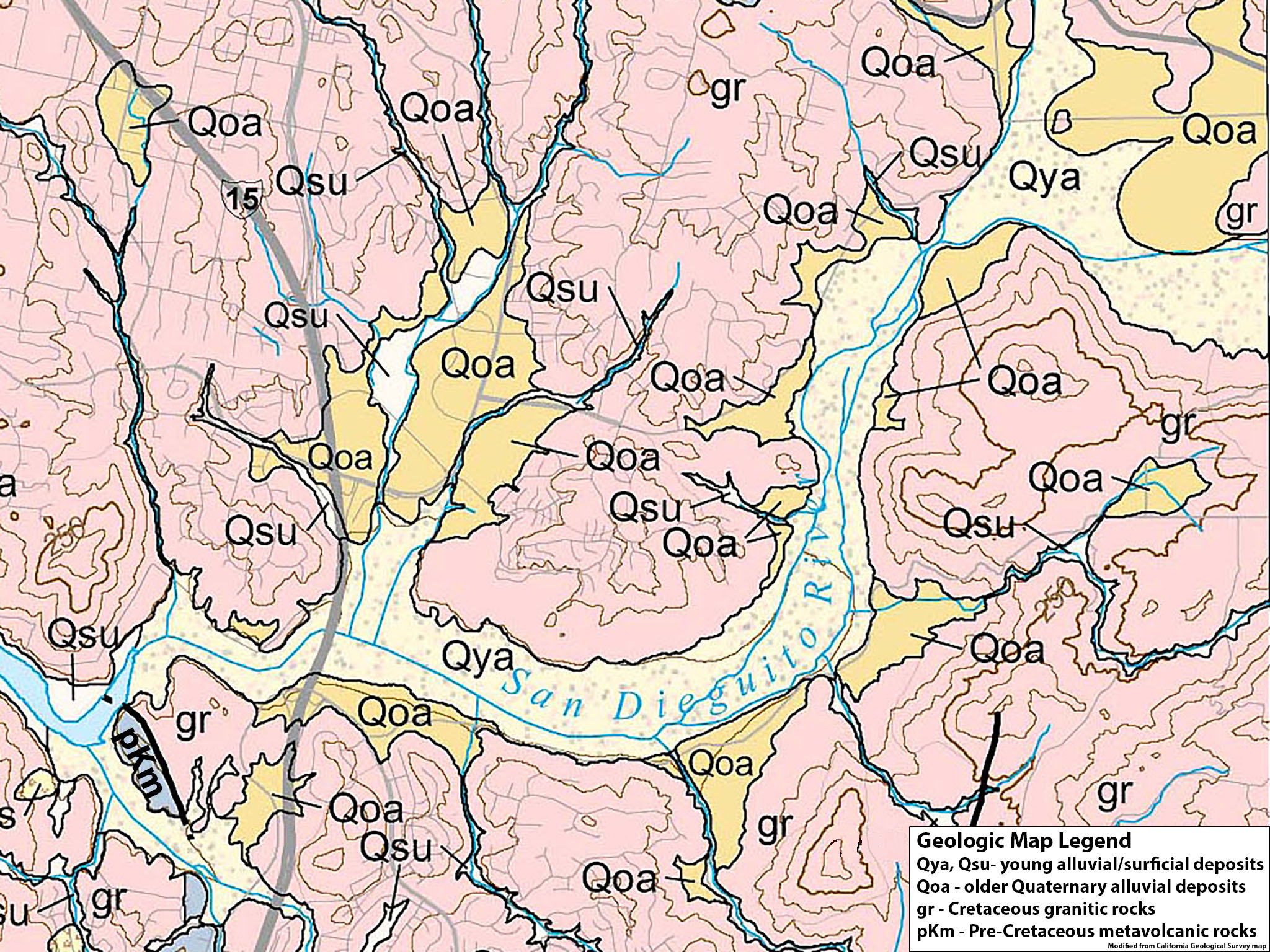
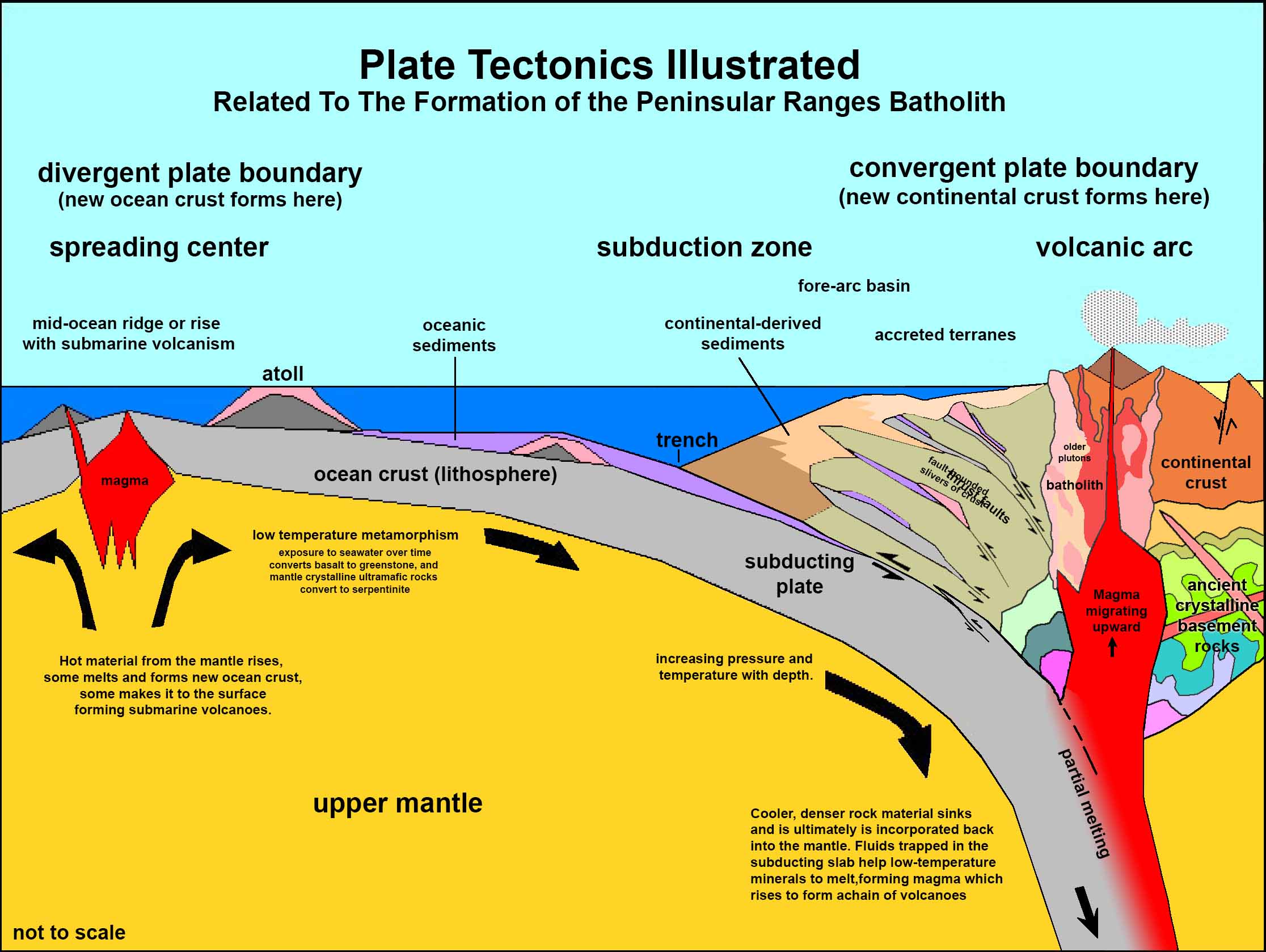
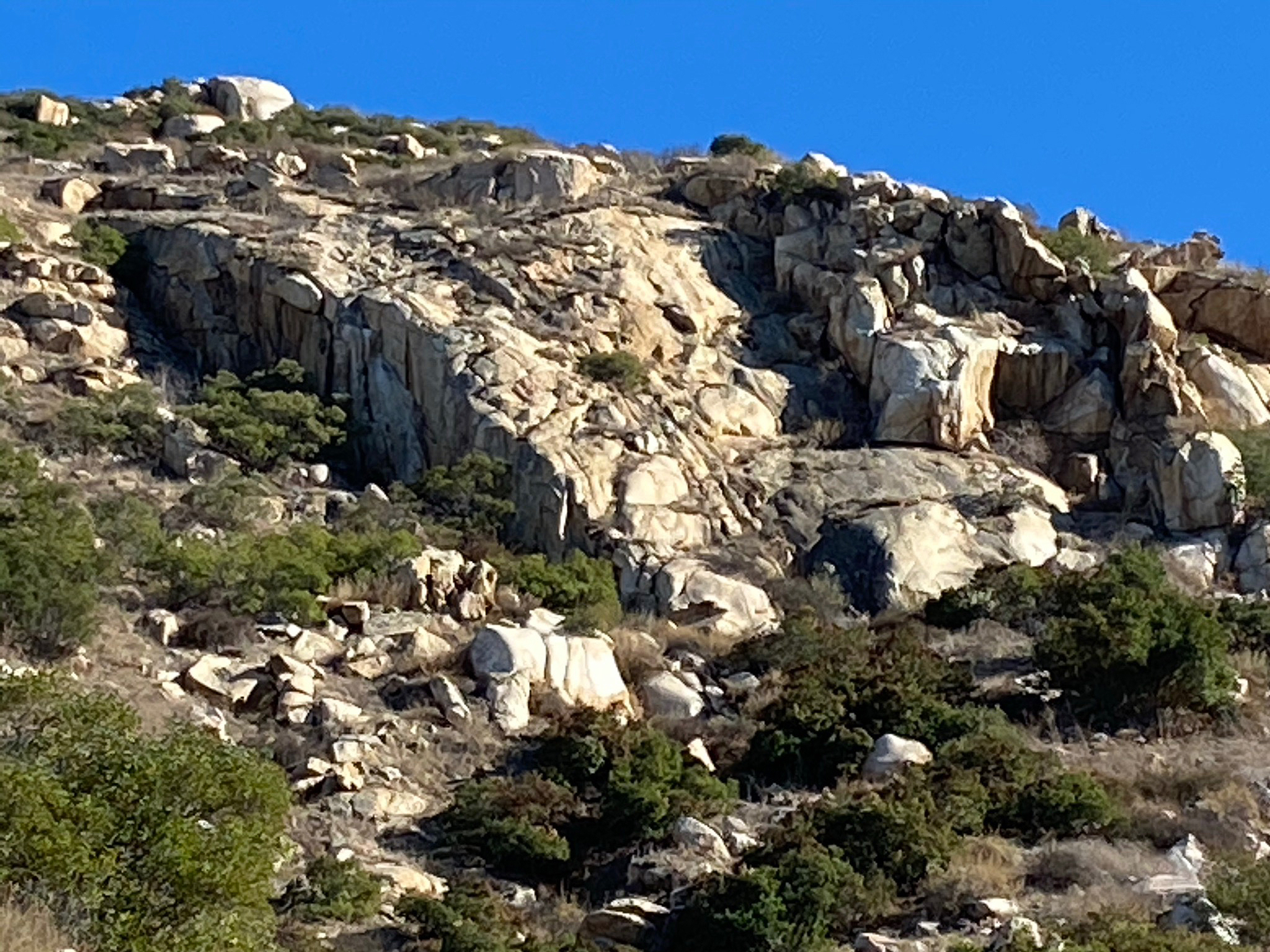

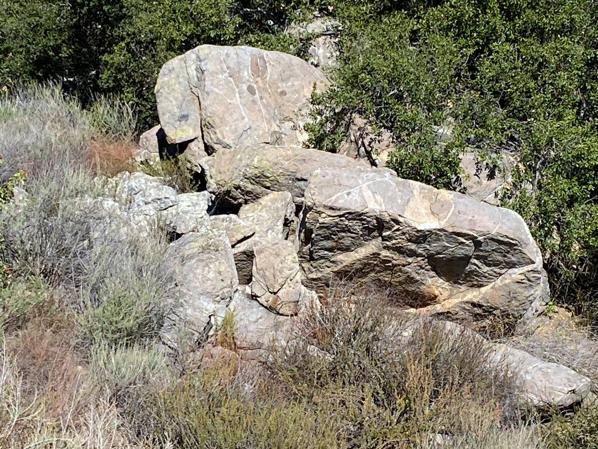
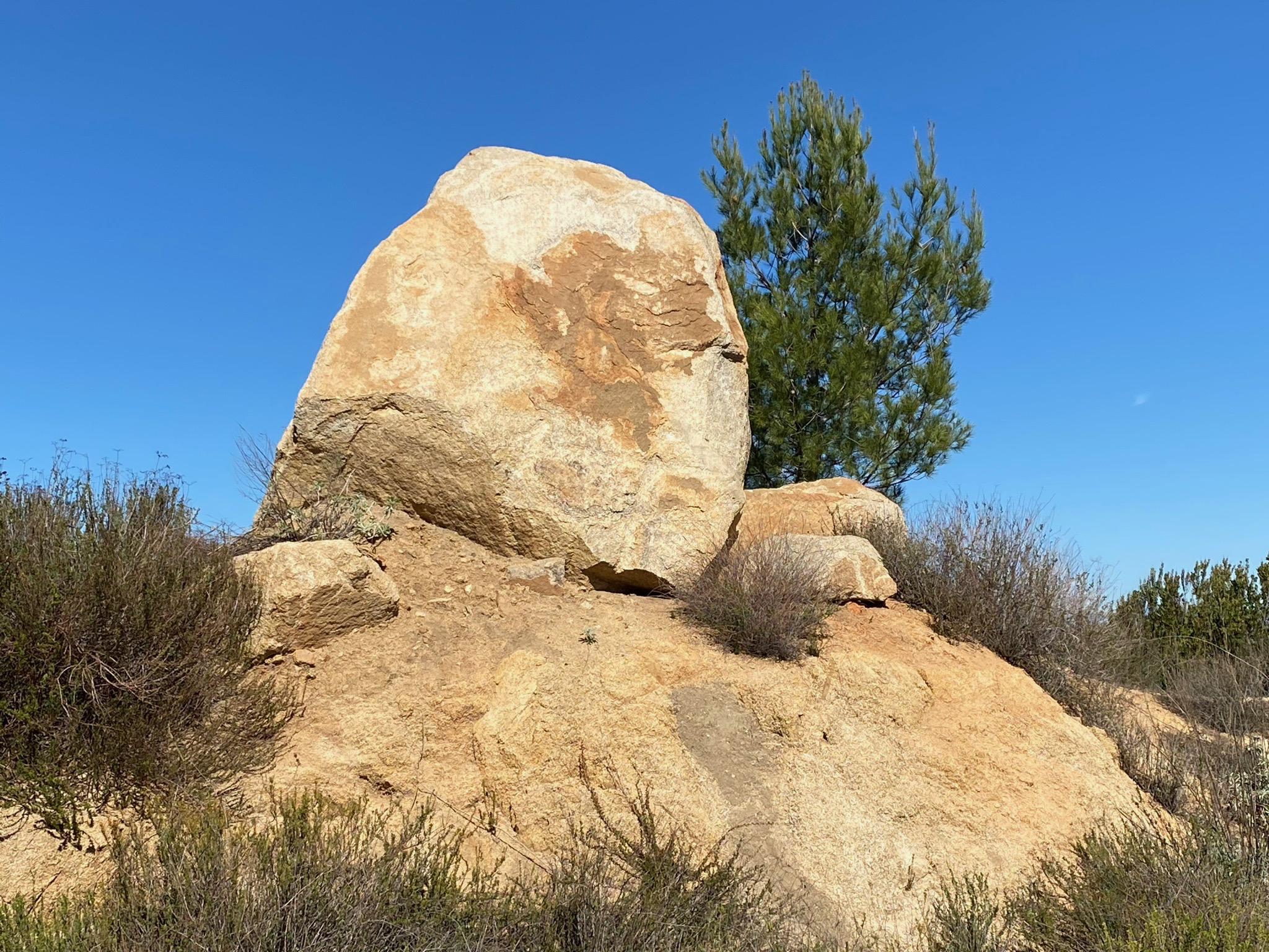
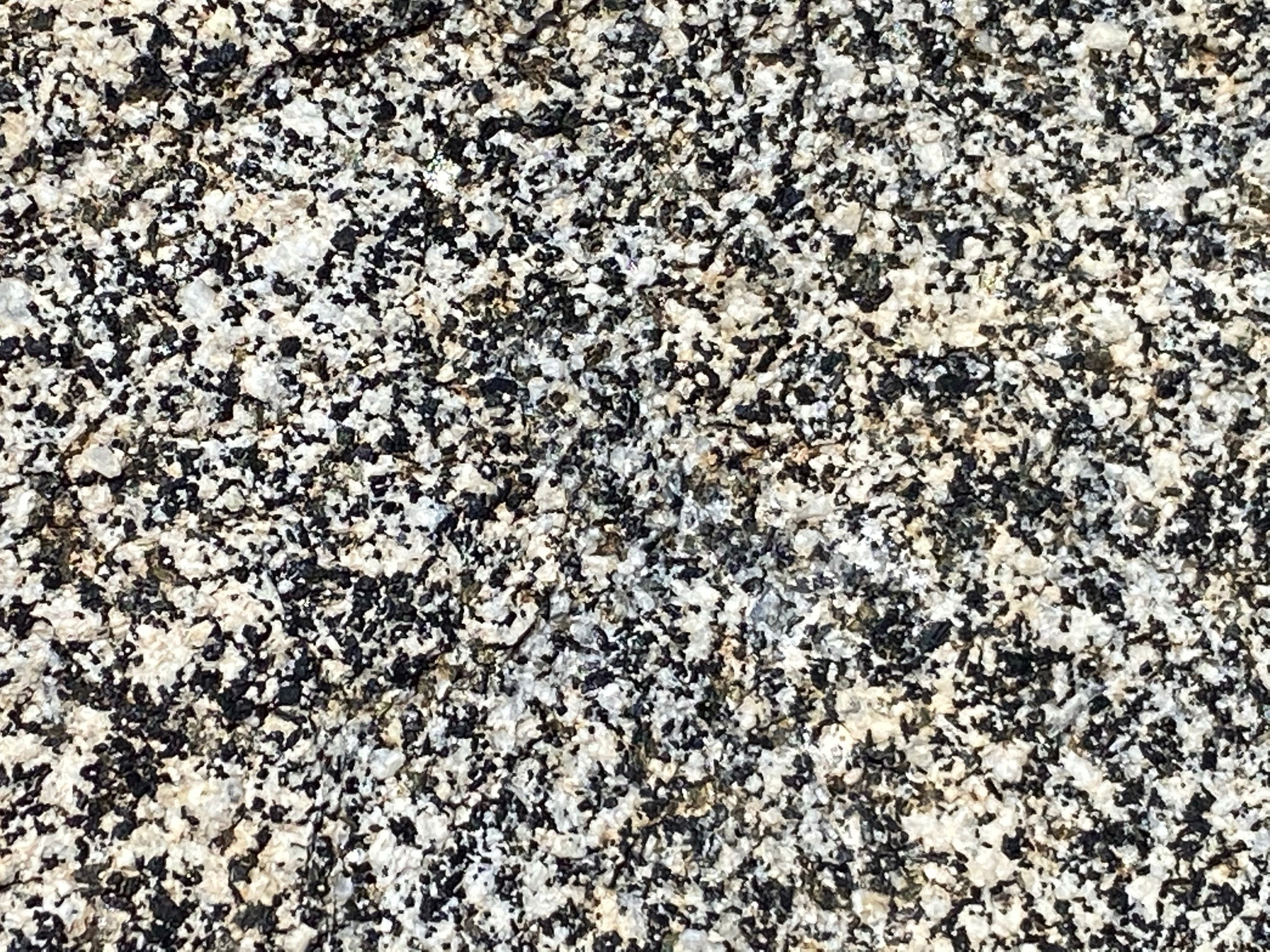
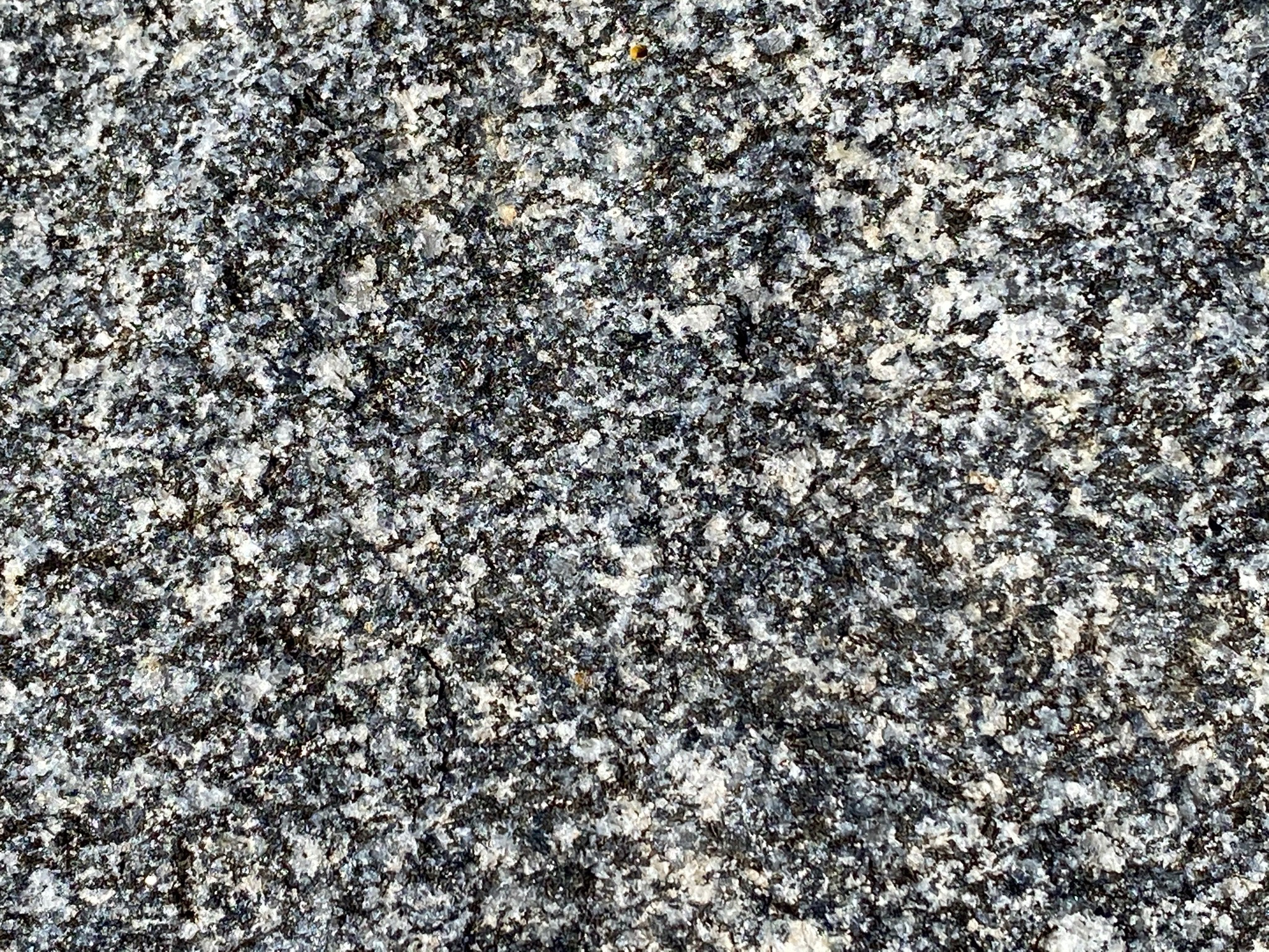
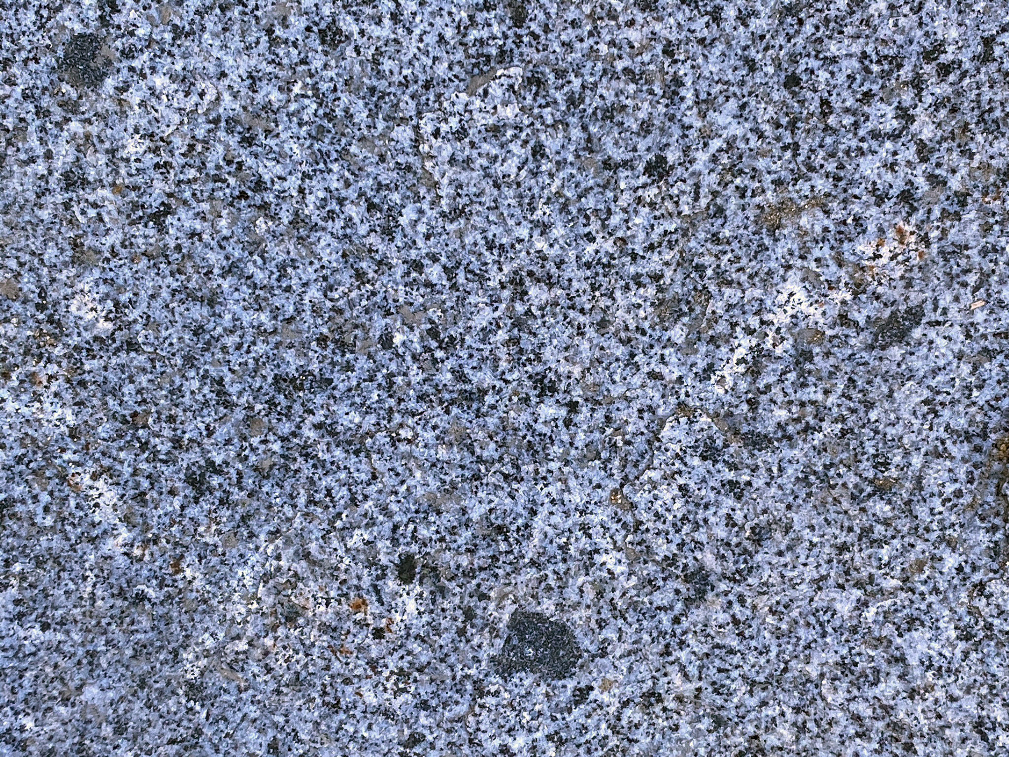
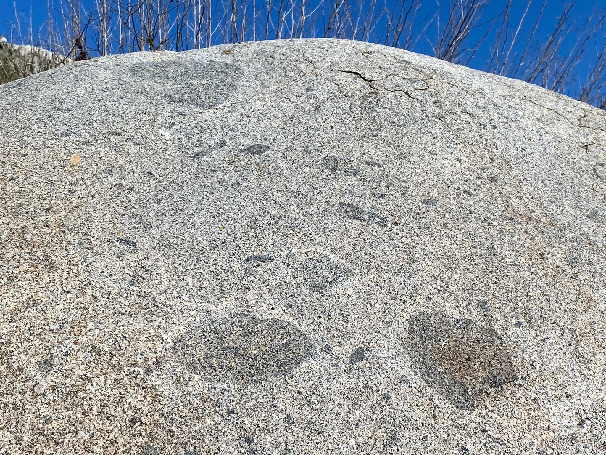
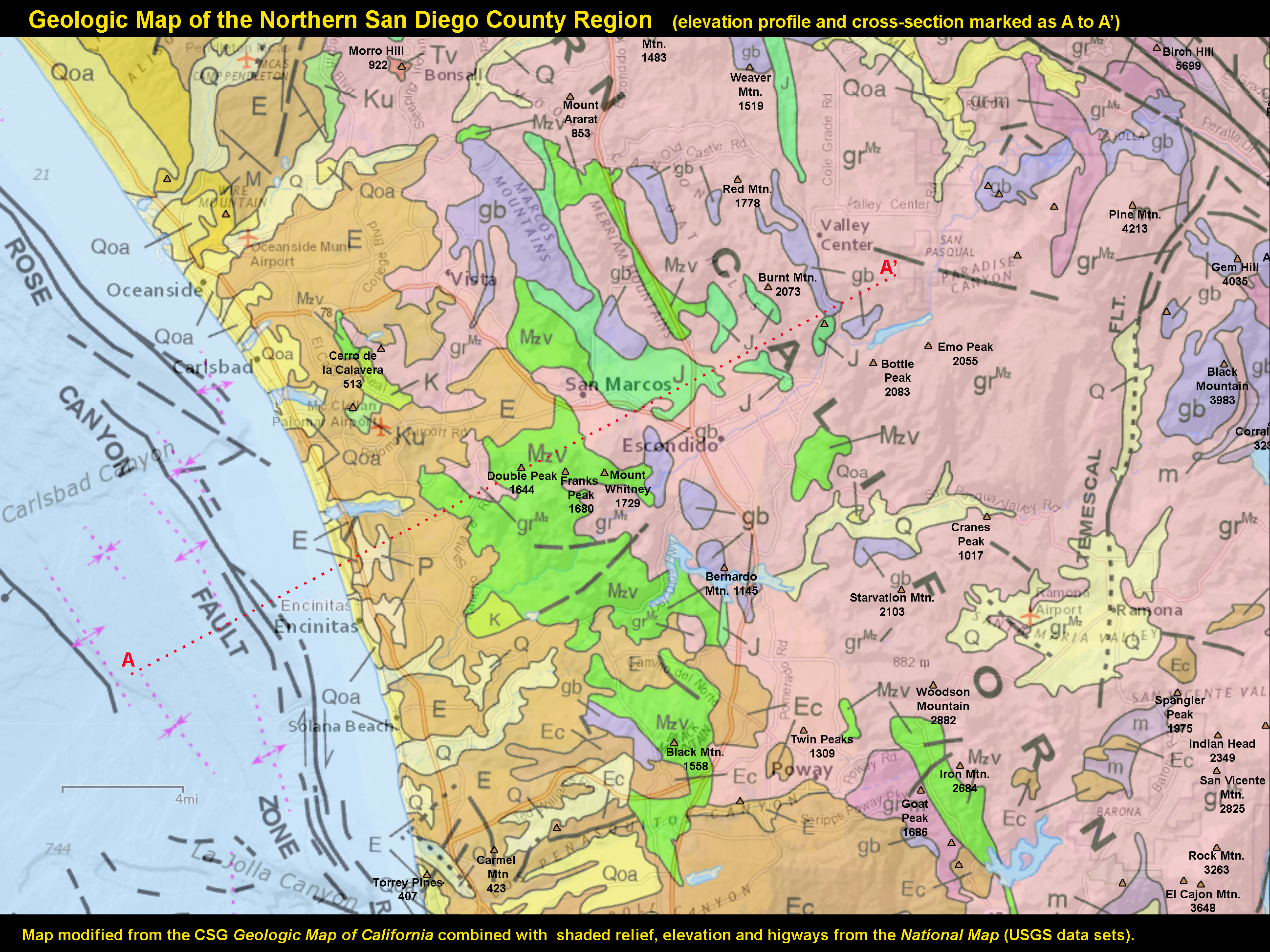
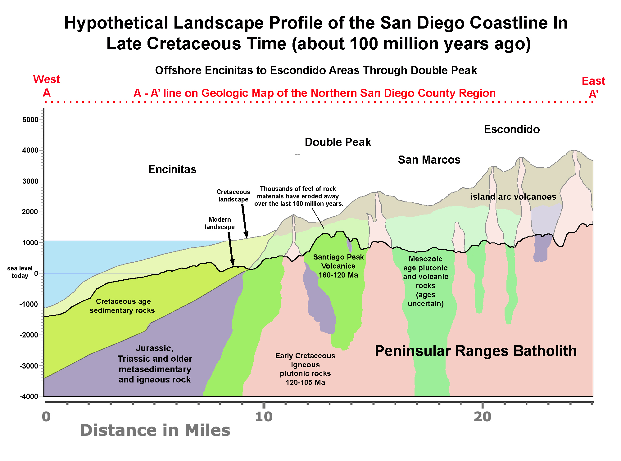
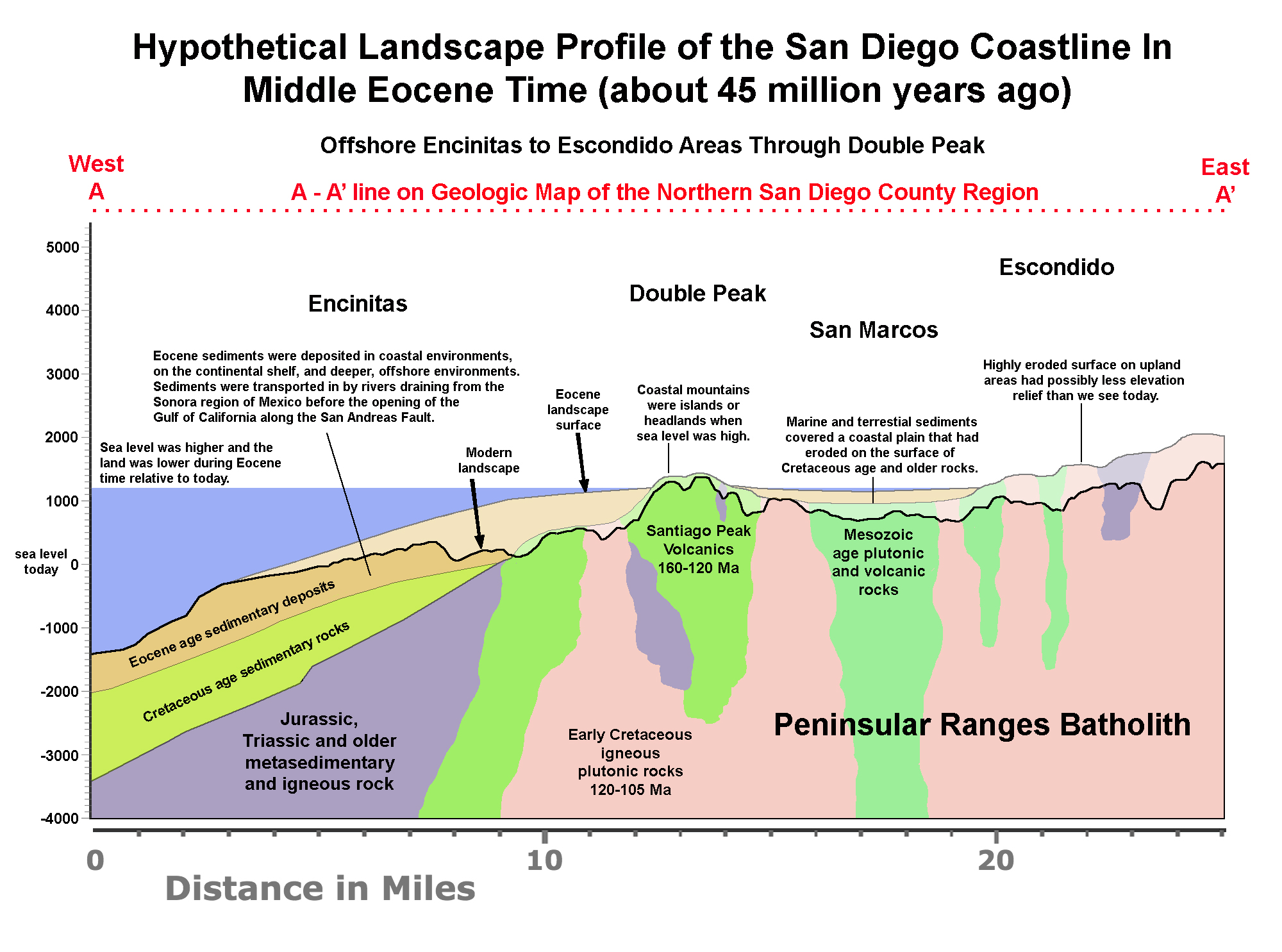

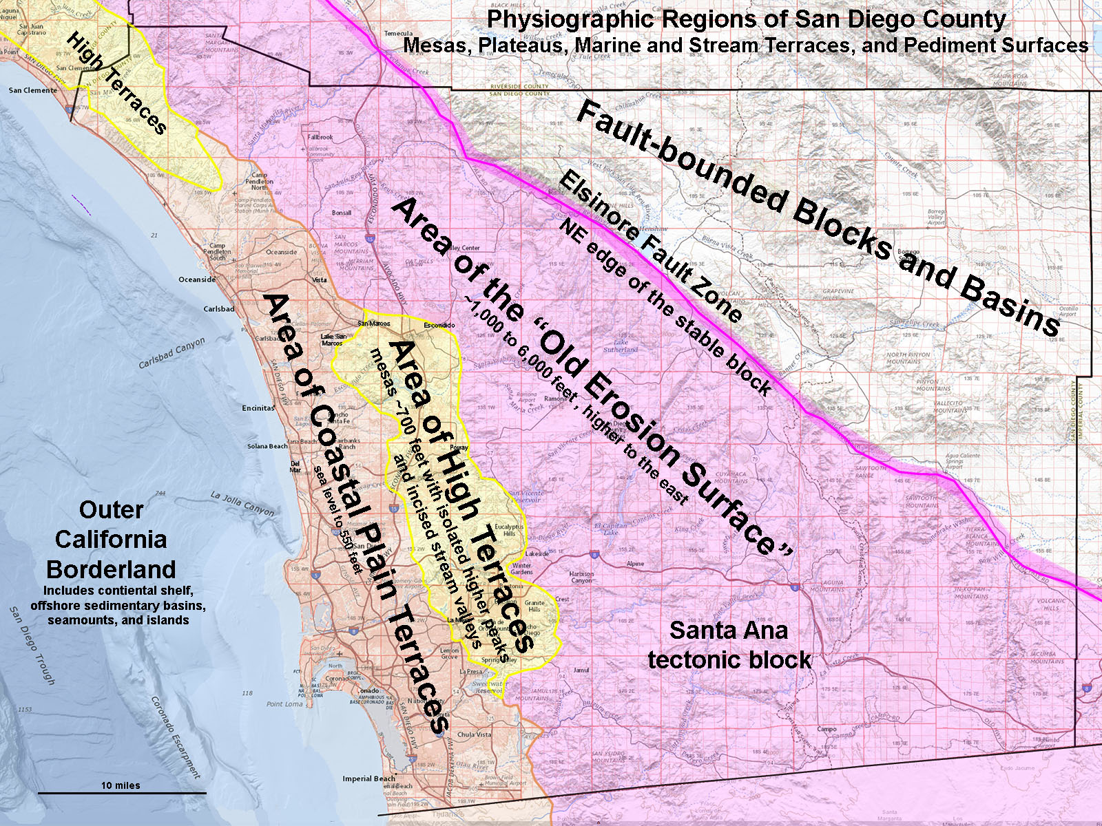 Fig. 18. Physiographic provinces of San Diego County. The Area of High Terraces is part of the stable Santa Ana tectonic block.